
It is weeks like this that I kind-of regret naming this blog “Walking Redwood City”; perhaps it should have been “Driving Redwood City” instead. Not really, though. Even though my walks this week were a bit extreme, they weren’t really that bad. For the record, on Monday I had to do a large loop in Emerald Hills that took me up to the Cross; that walk turned out to be just over 11 miles long. Then, on Wednesday I had to do two separate walks: one that was 3.2 miles long (and had me ascending Jefferson/Farm Hill as far as PCC) plus a 5.8 mile-long walk in which I walked home from far out in Redwood Shores. But I guess it was worth it: my average daily step count (not that I obsessively track such things) has gone up nicely…
Showing just how I don’t always plan things as well as I could, it wasn’t until Easter Sunday that I realized that I really should write something about the “Easter Cross”—that large cross that sits on a high hill overlooking all of Redwood City. While such a post might have been a bit more appropriate last week, well, better late than never, right?

Our Easter Cross—for that is its proper name—was first built on its current site in 1929 by Leonard and Holt, a prominent San Francisco building firm who was instrumental in the creation of Emerald Hills. The cross as originally built was 82 feet high. In 1960 the cross was vandalized, and had to be rebuilt. The new cross (our present one) was made larger: it reaches 94 feet into the sky. Why was it enlarged? It seems that there was a bit of a “competition” with the cross on San Francisco’s Mount Davidson. After several incarnations, in 1934 today’s version of that cross was built. The Mount Davidson cross is 103 feet tall, sitting on top of a 927 foot mountain. Thus, the San Francisco cross touches 1030 feet. Our cross, on the other hand, sits upon a 940-foot-tall mountain. At its original 82-foot height, it only reached 1022 feet: 8 feet lower than San Francisco’s. By increasing our cross’s height to 94 feet, however, it gained a measure of superiority: its tip is now 4 feet above the tip of the cross on Mount Davidson. [As it turns out, this story may be apocryphal. Take it with a grain of salt.]
While the Easter Cross is the most visible landmark at the top of Emerald Hills, and is thus familiar to most Redwood City residents, what many people aren’t aware of is the adjacent Easter Bowl: an outdoor amphitheater built above the intersection of California Way and Tom Suden Way. Services (including an animal parade!) used to be held in the Easter Bowl, but it was abandoned in the early 1980’s and the area has since become overgrown. While I value the wild space that now is the Easter Bowl, I wish I had been there when it was in use—services there must have been something to behold!
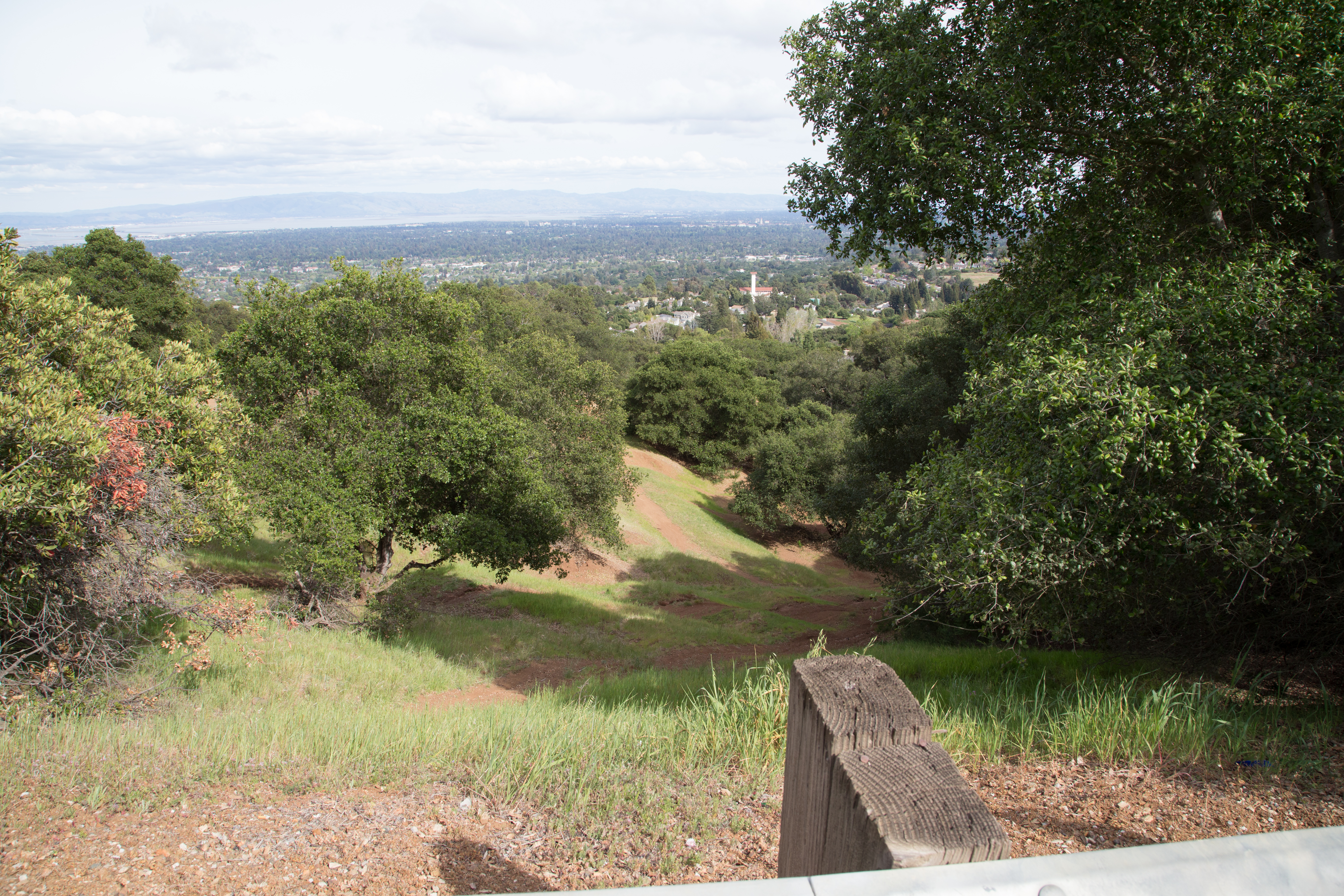
The Easter Bowl property is currently owned by the City of Redwood City, and it is ostensibly managed by the Parks and Rec Department. However, other than a few signs it is completely wild. There is a steep path running from the bottom—on California Way, just up from the intersection with Tum Suden Way—to the top, just below where the Easter Cross stands. I walked the path on Monday, and came across a teenager who was building a BMX (bicycle) track. The area must be ideal for kids in the area—a rare vacant lot that will remain undeveloped, where they can roam and let their imaginations run wild…
After I came up with the idea to write about the Easter Cross, I did a bit of research and realized that I really didn’t have enough material for an entire post. But in doing the research, I stumbled across a web page that had the words “Easter Cross” and “Easter Bowl” in it—one that had nothing to do with the cross or the bowl itself. It was this one: a web page maintained by “BAWSCA”, the Bay Area Water Supply and Conservation Agency, that summarized the workings of Redwood City’s water utility. The phrases “Easter Cross” and “Easter Bowl” are in it because two of the ten storage reservoirs used to supply us with water are up there: one sits right next to the Easter Cross, and the other sits just a bit further down the hill (and is thus tagged “Easter Bowl”). I almost skipped past the document, until I realized that with our current water situation this would be a great companion topic.
Redwood City’s water utility—the entity to which we pay bi-monthly for our water—not only supplies Redwood City, but also San Carlos, parts of Woodside, and various unincorporated parts of San Mateo County (including Emerald Hills). It serves a 35+ square mile area; some 86,000 or so people. The utility obtains 94% of its water from the SFPUC (San Francisco Public Utilities Commission), and stores 21.24 million gallons, or 2.2 days worth, of fresh (not recycled) water in ten reservoirs—eight of which are in Emerald Hills (the remaining two are in Redwood Shores). It is these reservoirs that keep the system pressurized, giving us the water pressure we experience at our taps.
Once I saw that there were ten such reservoirs, and knowing that I had seen some of them before (the large tanks, although painted to blend in with the scenery, are still easy to see), I determined to visit each one. The BAWSCA document, however, didn’t specify their locations. Instead, it simply gave each one a label. Those labels proved to be helpful to a varying degree: some indicated the street from which they were accessed, while others simply named a service area and thus didn’t do much for me. Fortunately, I realized that most (all but one, as it turns out) were round tanks, which would be easy to spot from the air. And the easiest way to do that? Google Earth, of course. Concentrating on Emerald Hills, it didn’t take long to find seven locations with visible tanks. And two likely locations in Redwood Shores were just as easy to find. Newly armed with their apparent locations, I dug through the Redwood City document archives to confirm that what I was looking at were indeed water tanks, and not storage vessels for something else.
Seven tanks in the hills plus two in Redwood Shores makes nine. But where was the tenth? Because the largest of the reservoirs consists of two huge tanks, I tried to convince myself that perhaps that site counted as two. At least one other site consisted of two tanks, however, and that one wasn’t counted twice, so I didn’t have great confidence in my assertion. Nevertheless, after additional searching with no luck, I resolved to visit each of the nine I did know about, hoping that I’d find the tenth along the way.
After putting on a broad-brimmed hat (I knew I’d be out for hours, and I’ve finally developed the good habit of protecting my skin from too much sun exposure) and strapping my camera bag to my back, I headed to the intersection of Alameda del las Pulgas and Jefferson. Then, I began the long slog up Jefferson and Farm Hill. My first destination was near the main entrance to the Shinnyo-En Buddhist temple on Bret Harte Dr., and I knew from past excursions that the simplest way to get there was to go up Farm Hill to Emerald Hill Rd., turn right, and then head left on Bret Harte Dr.
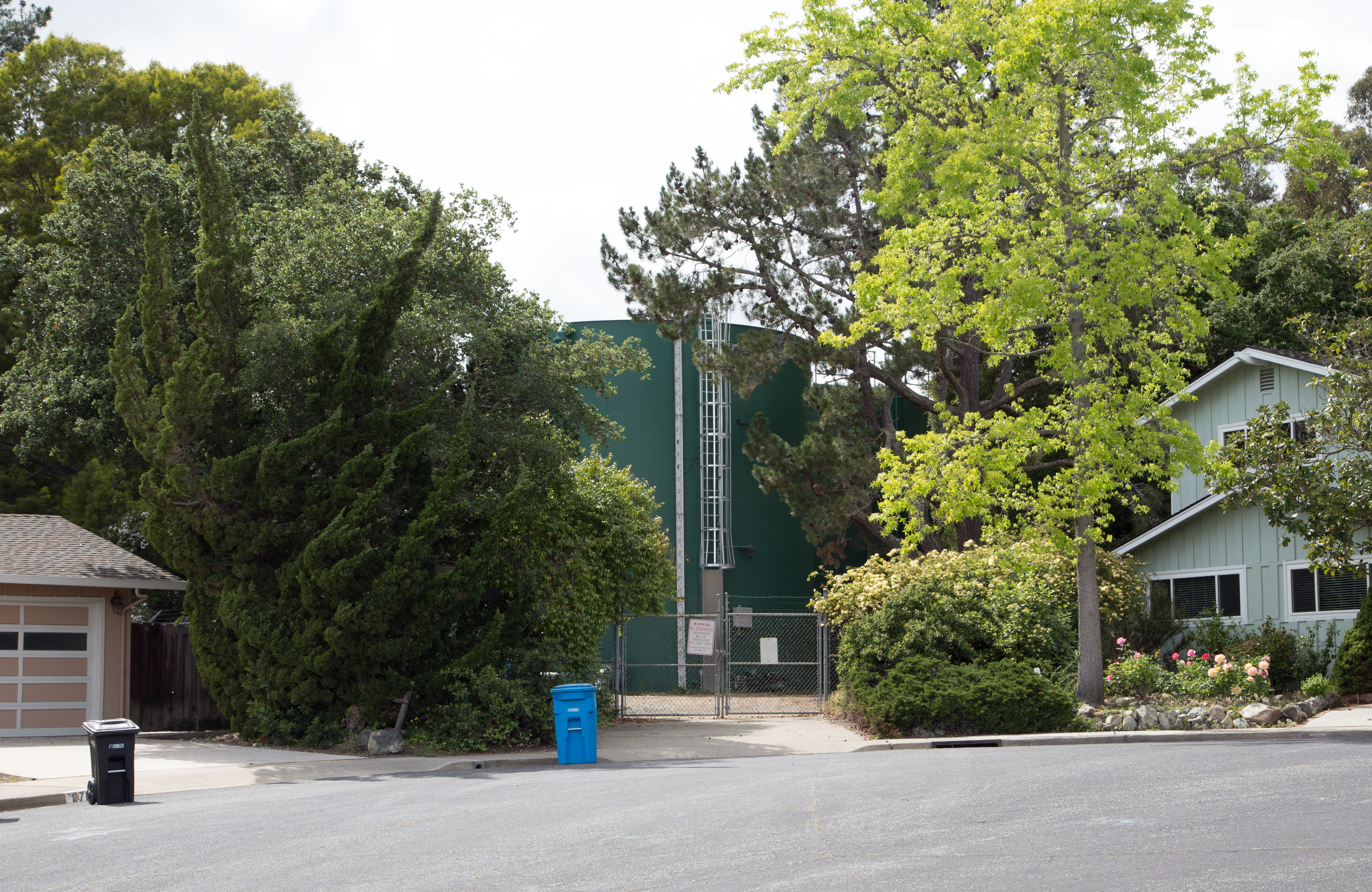
The “Cambridge” tank can be found at 664 Cambridge Rd.; Cambridge is the crossroad I came to after turning onto Bret Harte. In any case, the tank sits at the end of a short cul-de-sac with houses on either side. This site holds 650,000 gallons in a pair of steel tanks (only one of which is visible in this picture):
A wooden sign to the left of the gate indicated that I was indeed looking at the “Cambridge Water Station”. Happy that my scheme to locate these tanks using Google Earth was bearing fruit, I then headed through the temple grounds to the next tank, which is very close to the gate that keeps traffic (but not pedestrians) from transitioning from Bret Harte Drive to Wilmington Way. This next tank—referred to as “Wilmington South”—is at 968 Wilmington Way and actually backs onto the first tee of the Redwood City Elk’s Lodge golf course. It is a substantially smaller reservoir, holding only 250,000 gallons in a single steel tank:
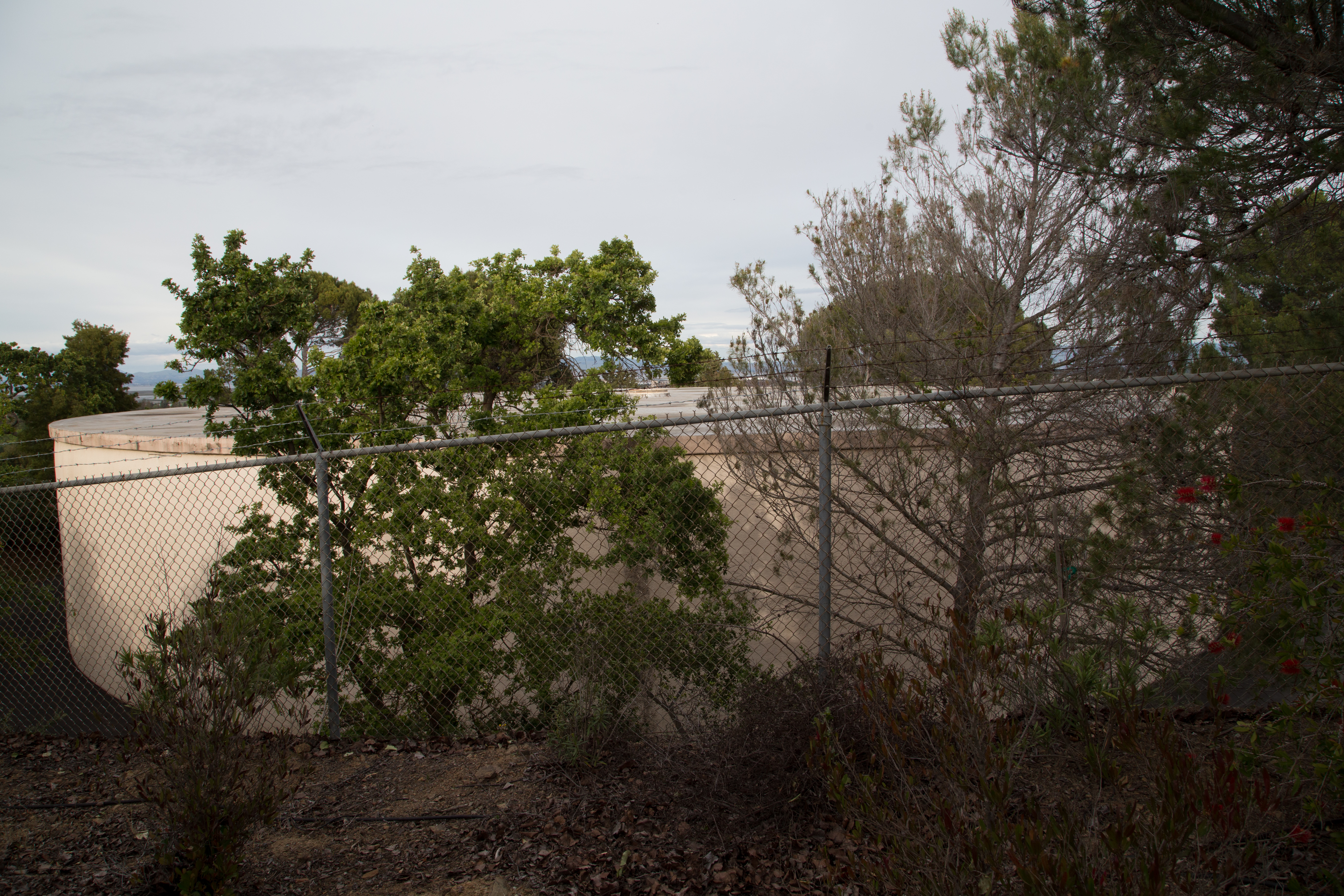
By this point in my journey I had done a substantial part of the climb; now I had to face the final ascent, to the highest point in my journey: the tank at the Easter Cross. This tank is yet again smaller, at 100,000 gallons. And though you wouldn’t know it from my earlier picture of the cross, the tank sits right next to the cross’s base:

Given its location you’ll not be surprised to see a number of antennas as well: my understanding is that at least some of the money the cell phone companies pay to have their towers on this rather ideal spot goes towards upkeep of the cross itself.
The cross and the tank (and the antennas) stand at the top of the hill, within a fenced enclosure. Below them, on California Way, sits the 1.2 million gallon “Easter Bowl” tank (directly across the street from this tank is the Easter Bowl itself):

From here, the remaining tanks were all downhill—to my relief! I now headed towards the upper end of Edgewood Park, since my next goal was the tank located at the corner of Hillcrest Way and Glenloch Way. This tank, “Glenloch”, is the smallest of the bunch, at 90,000 gallons. Although visible from either street, as the name implies the access to this tank is off of Glenloch Way:

From Glenloch it was an easy stroll to my next target: the “Lakeview” tank, on, you guessed it, Lakeview Way (815 Lakeview Way, to be precise). For those of you who basically know the area but don’t know where this is just by the address, draw a line between Emerald Lake and Upper Emerald Lake and you’ll find the Lakeview tank in the middle.
From Google Earth I thought this one was going to be off of Ventana Ct., but fortunately it wasn’t: to get close I would have had to go down a posted private road. As it turns out I walked right by the access gate for the Lakeview reservoir, and had to backtrack in order to find it. My only excuse is that this one doesn’t stand out like the others: the one-million-gallon Lakeview Reservoir is underground. The only thing that can be seen is a giant lid that looks as if a UFO has landed without deploying its landing gear:

From here, I headed towards home. That is because the seventh and final stop on that day’s walk was Redwood City’s main reservoir, which is located in the hills above my home. Just above Sequoia Hospital, in fact, midway between the hospital and the Canyon Inn restaurant.
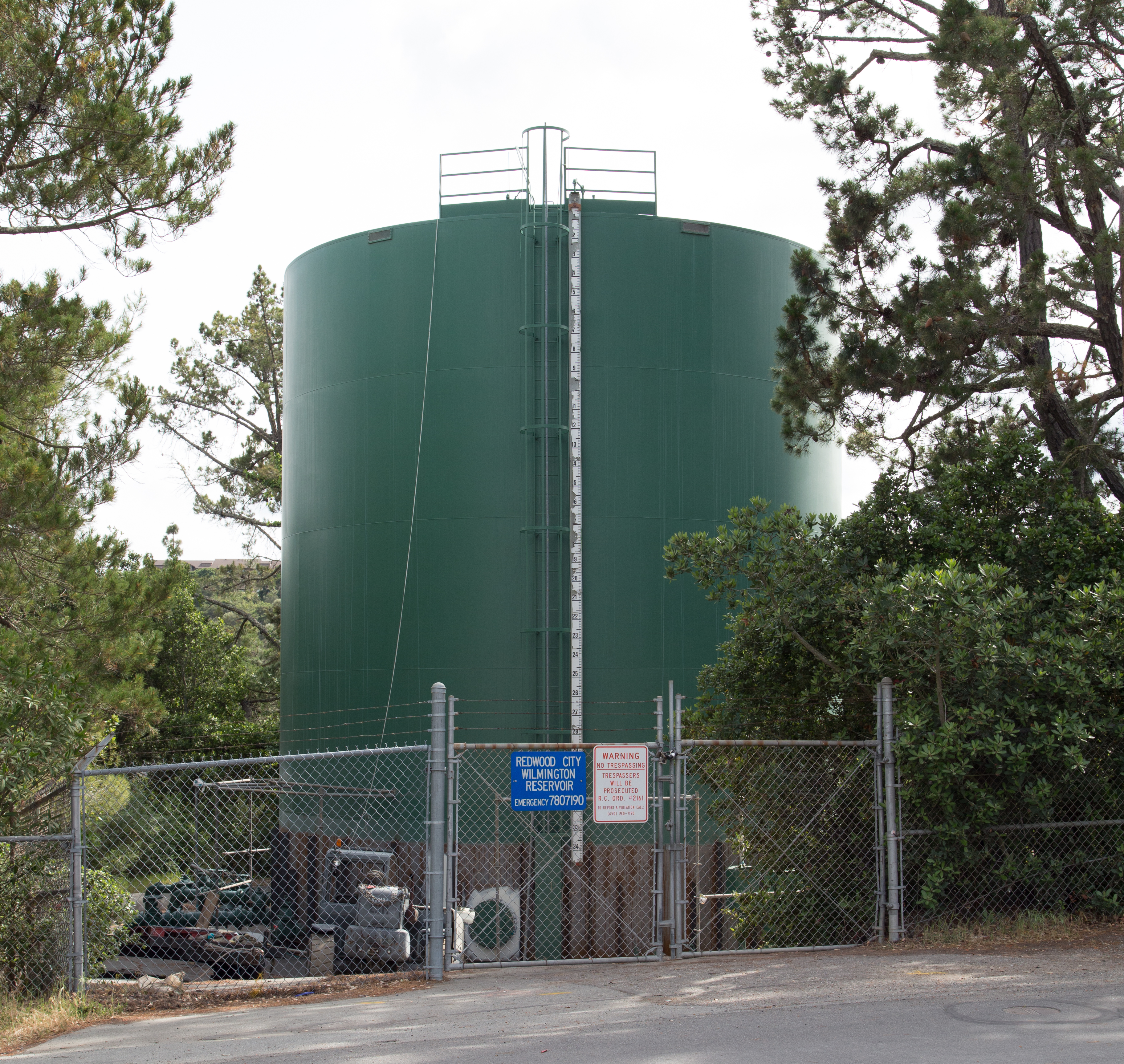
This site is a whopper: it holds eight million gallons of water in two huge tanks. The main access gate for these tanks is off Hillcrest Dr., which is just off Oak Knoll Drive. But you can actually get a somewhat better view of tanks by heading down to Cordilleras and then heading up Bennett. I had hoped to end my walk by heading straight home from the main entrance (I was so close!), but after looking at the map I realized that I had to see what they looked like from Bennett. With tired feet I backtracked to the Canyon Inn, walked down to Cordilleras, and then hiked up the rather steep Bennett Rd. to where the backside of the tanks were clearly visible. That is where I took this photo:
So that was the seventh reservoir on my tour. At no time had I noticed any evidence of an eighth. Unfortunately, my examination of the two huge tanks off Hillcrest gave me no confidence that the two tanks were counted separately: there had to be another reservoir out there!
Because the next day, Tuesday, was to be the day of our big rainstorm, I resolved to continue my online research into the missing reservoir that day. I had already planned to visit the two additional Redwood Shores reservoirs on Wednesday, and figured that unless the lost reservoir was within an easy walk, I’d just drive to it.
I’ve gotten somewhat good at searching Redwood City’s document archives, and on that Tuesday I redoubled my efforts—which finally paid off. I found a mention of a “Carson” reservoir, which didn’t appear to be an alternate name for the ones I already knew about. At first I thought perhaps that it might be located on “Carson Street” or some such, but we don’t seem to have one. Then I looked at a different map, and suddenly there it was! It seems that I had walked right by it (although on the other side of the street) on Monday: the Carson Water Station sits almost directly across Farm Hill Blvd. from Peninsula Covenant Church (PCC). The reason I didn’t find it before? It is entirely belowground, so from the street it looks more like a parking lot than a water tank. And it is rectangular, not round, so from the air it looks like a flat building roof. From the ground it is actually a bit tricky to get a good picture of; this is the best I could do:

Carson is another huge reservoir: it holds 3.75 million gallons of fresh water. This reservoir and the giant one on Hillcrest link up to serve what is termed the “Main City Zone”: an area that includes our downtown, the Seaport area, and certain residential neighborhoods within the city that are adjacent to the bay.
Because of the Carson Water Station’s location I was indeed able to walk to it on Wednesday; this was the 3.2-mile walk I did that morning. But I still needed to get to Redwood Shores. I have to admit that the round-trip to Redwood Shores and back would have exceeded 10 miles; on top of the three I already did, plus the eleven miles I did on Monday, that was just too much for me to face. Instead, I had my wife drop me off at the farthest point I needed to be in Redwood Shores, and I walked the nearly six miles back from there.
Redwood Shores has two sizable reservoirs servicing the area. The first (labeled “Peninsula No. 1”) holds 3.2 million gallons in a single large tank; it can be found at 680 Redwood Shores Parkway, behind and slightly adjacent to Fire Station No. 20:

As for the second reservoir (“Peninsula No. 2”), it is only slightly smaller: 3 million gallons in a single tank located at the southern end of Twin Dolphin Drive. As I discovered, simply follow Twin Dolphin to where it dumps you into the parking lot for the Marriott TownePlace Suites hotel, and look to your left: it’s rather hard to miss:

After circling this last for the best angles, and taking a short stroll out into the bay, I then had a delightful walk on the section of the San Francisco Bay Trail between the San Carlos Airport and Whipple Ave. I won’t say more about that here as I hope to do an entire post on that trail at some point. But I had a great time walking by the airport, reminiscing about when I was working on my pilot’s license there. I also watched a Surf Air plane take off; I’d heard that there were some commercial flights going out of San Carlos Airport but didn’t know about these guys.
After two long days of walking totalling some 20 miles, I managed to visit all ten of the fresh water reservoirs that supply Redwood City and surrounding communities. While water tanks aren’t the most exciting things to see—after all, they just sit there—I had a very enjoyable journey, and an educational one as well. I like to know how things work, and it is satisfying having put these pieces of the water-delivery puzzle in place. Incidentally, it appears that in the near future the city plans to construct a three million gallon tank somewhere along 101 (on the east side, apparently) to accommodate Kaiser, Stanford in Redwood City, and other large users in the area.
I’m very glad I walked; I got some great exercise, and the walks helped me get into better shape for some future ones I have planned. I was definitely kidding about changing the name of the blog; I continue to be amazed at what you can find just by walking Redwood City.

I’ve always wondered about the history of Redwood City’s biggest eyesore. Thanks for posting this information. It’s interesting to know that the cross turned into a Christian pissing contest between the cross up north. So childish! Every time I look towards the hills I am saddened by that gigantic, conspicuous monument to superstition. It would be wonderful to see it destroyed one day. There’s absolutely no reason why city funds should be spent maintaining such a worthless structure, especially considering that churches don’t pay any taxes.
Due to understandable constitutional church-state separation legal challenges, I don’t believe public funds are used to maintain any such crosses in the US anymore. At least in some cases I recall reading about, the land they occupy has been legally sold or somehow transferred to private / non-governmental organizations.
Indeed, as far as I know that cross stands on private property and is privately maintained. No governmental funds or involvement at all
Thanks for this post Greg. Just got linked to it in my hopes to understand the abandoned site that one of your previous commenters noted, 540 Upland. Have you been able to find any information through county websites about this? Thanks for your blog, great way to learn a bit more about home.
Easter Sunrise Services were so early,cold and SPECTACULAR !
When the sun rose snd warned our little faces it felt holy!
Thanks for writing about your tank-treasure hunt! Very interesting 🙂 I was looking up Emerald Hills and came across your blog. Amazed that you walked all the way from Redwood Shores!! I don’t usually leave comments but thought it might be encouraging to know people are enjoying it 🙂 Keep walking, keep writing.
Back in the 40s there was a reservoir at 540 Upland, head of Brewster.
Pingback: Neighborhoods: Farm Hill | Walking Redwood City
Really enjoyed reading and following your hikes here. I grew up in Palomar Park, which has its own water tank you missed! That won’t be a very long walk for you to check out, at the top of Loma Road, if my memory serves me. Loved growing up in the old Redwood City. My grandfather wrote the city slogan. We attended the Easter Sunrise services at the cross every year through high school. I eventually settled further north where development has yet to (over)reach and the towns are much like what RWC used to be.
Pingback: A Watershed Moment | Walking Redwood City
What’s the source for 94 feet? All old nusclips say 73.
There are several. Google “Redwood City Easter Cross 94” and you’ll get hits on Patch.com, Wikipedia, RedwoodCity365.com, Emerald Hills History (www.emeraldlake.com/history.html), and more.
None of the sites cite a source. Mystery here. The Easter Cross Association says 73 feet. So do nup morgues. Also the guy who paints the cross.
Just measure its height from the ground using a clinometer.
Reality check: Let me know what you come up with.
I don’t give a hoot how tall the damn cross is! I just pointed you to how to definitively measure its height.
As an atheist, I may only have one less god than most religious people, but I don’t appreciate it towering over RWC any more than a satan-fearing Christian would appreciate a giant pentagram up there. In my view, religion is a pernicious form of “viral” (taught) mental/thought disorder that has caused (and continues to cause) more misery in the history of mankind than any other concept. But I digress …
Reality check. Need level ground for that. Not much of that up there. Sorry I asked.
Water pressure must be amazing at the TownePlace Suites.
Could be! Certainly their proximity to that large Redwood Shores tank has gotta help.
Speaking of the cross, have you seen the goats that are doing ‘clean up’ duty down in the Easter Bowl? Saw them yesterday morning and would have attached the photo if I knew how!
Yep, I saw them. I have a picture or two. They seemed to be doing a great job on the grass!
I’m not sure exactly why but this blog is loading incredibly slow for me.
Is anyone else having this issue or is it a problem on my end?
I’ll check back later on and see if the problem still exists.
This is my first time visit at here and i am really impressed to read everthing
at one place.
You sure about the cross being on city property and being managed by the city’s Parks & Rec Dept.? As one of the ever-growing number of “out” atheists, I’ve never been a fan of construction, display, maintenance or ownership religious symbols or inscriptions (e.g. crosses, pentagrams, Stars of David, etc.) on public property. You know, church-state separation and all that.
Not the cross. The Easter Bowl, which is right below it. I can see how I might have muddied that a bit, though, so I’ve modified the post slightly to clarify that the bowl is separate from the cross. I have run across mention that the cross itself is managed by a foundation of some sort; I don’t know for sure about who actually owns the property the cross sits on but would presume that the foundation does (or at least has a lease or something). At least some of the funds from the cell towers appear to go to the foundation to pay for upkeep of the cross. I haven’t found any mention of a connection between the city and the cross itself. Just the Easter Bowl, which is across the street.