
Before I set out on one of my walks I round up a few essentials: a full-brim hat (for sun protection), my digital SLR and an additional lens or two (to better photograph things that catch my interest) and, of course, my cell phone. On more significant walks (those that I anticipate being more than a mile or two), as I leave my house I launch an app called Map My Walk. As you might guess, Map My Walk allows me to keep track of where and how far I ended up walking. The total distance is usually what I care about most, although occasionally I look at the map produced by the app to refresh my memory on the exact route I took. But the app tracks other information as well, including my walking pace. I currently have it set to speak to me after each mile walked, announcing the current time, my pace for the last mile, and my overall pace for the entire walk so far.
I have Map My Walk set to pause its data gathering whenever I stop—whether it is for a red light or because I’m taking a picture—to ensure that the pace it records is only for when I’m actually walking. But even so, my pace varies quite a bit from mile to mile, and from one walk to another. For me, a leisurely pace is about 20 minutes per mile (or 3 miles per hour). Because I am usually out for exercise in addition to gathering information for my blog, however, I try to keep my pace in the 17 minute-per-mile range (just over 3.5 miles per hour) and often push to get it down into the 16’s.
What I find interesting is how the pace I maintain for a given walk reflects the character of that walk. If I set out with a firm agenda—a set list of projects I want to visit, for instance—I generally maintain a swift pace since I’m focused on particular targets and rarely deviate from them. But if the purpose of my walk is simply to explore and find new things to write about, I go at a much slower pace. Such was the case this week: I had a couple of specific things I wanted to check up on, but for the most part I elected to enjoy the relatively nice weather and just wander a bit. As a result, over the course of my 8.25 mile journey Map My Walk reported that my average pace was 19.5 minutes per mile. Although I may not have elevated my heart rate into the zone needed for a proper cardio workout, I did enjoy myself and I did find some small but interesting things along my journey.
First up, I’ve been meaning for a couple of weeks to take a good look at the house under construction at the corner of Hillview and Brewster:

I’m normally interested in any new house construction or significant remodel, but this one, as you can probably see, is a bit special: it includes a round tower on the Hillview side. Round rooms are rare because they are tricky to build and furnish, but like the house on Edgewood with a similar tower (that I’ve written about before), this one seems intended to house a spiral staircase—which neatly takes care of the furnishing issue. Round rooms add a great deal of character to a house, giving them a bit of a medieval feel.
This house helps to illustrate something that makes this part of Redwood City particularly special: all of the homes around here are unique, with nary a tract home to be found. The diversity of homes means that the passer-by has a lot to look at, which makes the area all the more interesting and inviting for a pedestrian such as myself. Not every house is a visual feast, of course—some are downright ugly to my eye—but the sheer variety means that if I don’t like one, well, I can just shift my gaze to the next.
To take the above photograph I stood in the triangular “parklet” across Brewster. From my vantage point I noticed some construction fencing about a block away, so when I was done I headed that way to see what was up. Given that there was still a house standing behind the fencing, I initially assumed that it was either about to undergo a significant remodel or perhaps a complete tear-down. But then I noticed some blue tarps on part of the roof and two vans parked in front: vans from an Emergency Services company that specializes in dealing with damage from fire, water, and mold. Together the tarps and the vans made me realize that this house had likely sustained damage in our recent storms. [Update: I’m told that the damage was due to a fire.] The construction fencing indicates that the damage was probably significant enough that the occupants were forced to temporarily relocate. Hopefully the cleanup and repairs will be done quickly, especially given that, as I write this, the rains have moved back into the area.
One of the things on my list to check on was Linden Park (which is located almost directly behind the University Art store on El Camino Real), so I took a rather meandering route to that part of town. On the way I passed another new house under construction—with no towers or other noteworthy features, regrettably—and noted that the former Dairy Queen on Woodside is indeed being reworked into something new. Although I didn’t see any actual activity at the long-suffering Hallmark House apartment building, I did observe that the green mesh fabric that is wrapping most of the building has definitely been updated: on my previous visit there were sections that were torn and hanging, while now all of the fabric is intact and hanging straight. I take this as confirmation that construction may indeed resume in April, as I was told by our Assistant City Manager.
On to Linden Park. I’ve written about it before, but that was a while ago. Linden Park is currently a long, narrow quarter-acre lot that slices diagonally across the residential block directly behind University Art. One corner of it is at the intersection of, curiously enough, Linden Street and Park Street. Here is a picture of the “park” from the back, facing towards that intersection:
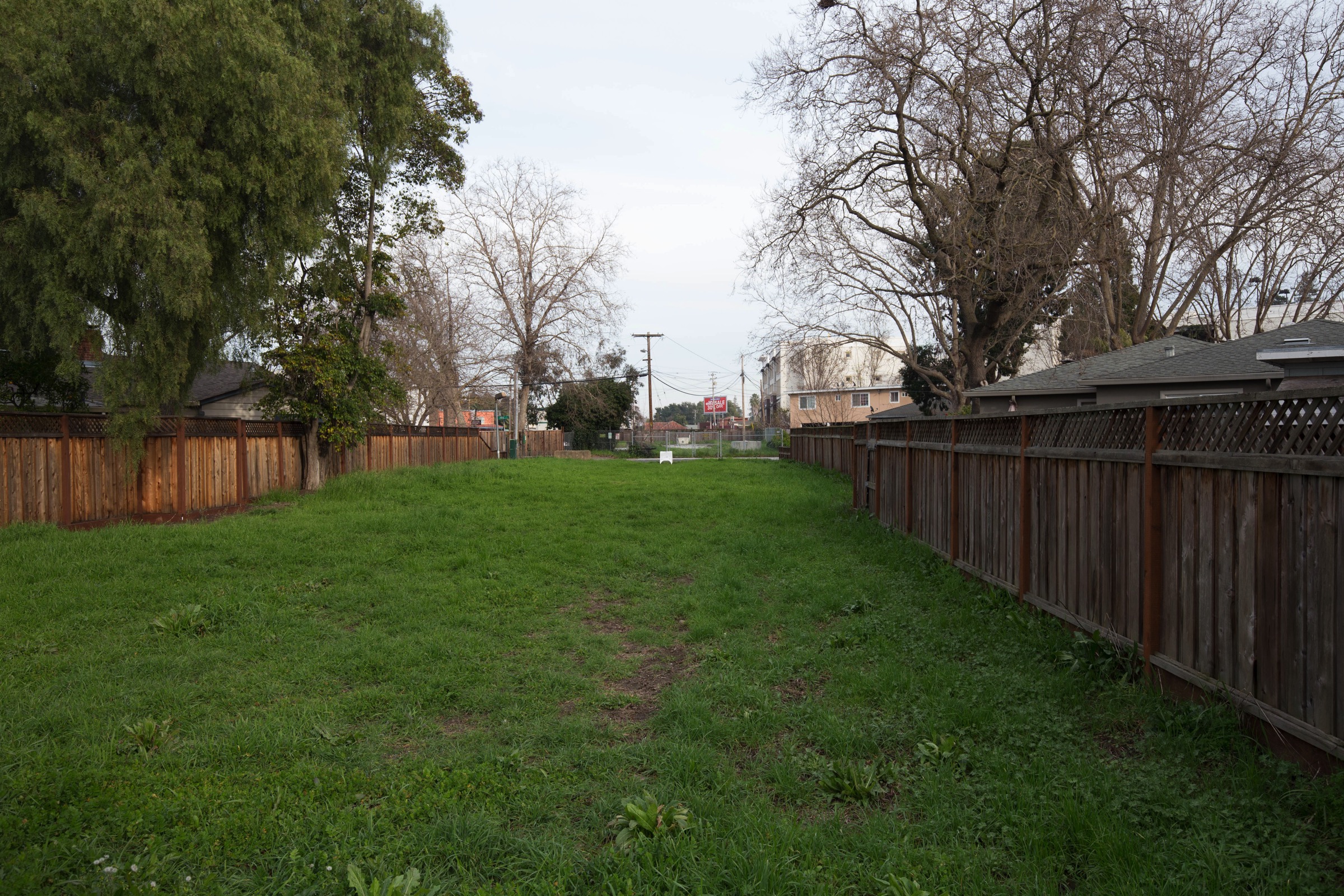
When I say “from the back” I should clarify that in truth while the land extends from one corner of the block to the other, currently there is a fence across the middle dividing the space in two. I took this picture standing against that fence, so it shows only about half of the park. The other half looks about the same, but faces in the other direction. For orientation purposes, in this picture that red billboard you see is out on El Camino Real and the white multi-story building to the right of the billboard is the “The Lane on the Boulevard,” the apartment complex that was built on the former site of Mel’s Bowl.
From its shape you can probably guess that this park sits entirely on the Hetch Hetchy right-of-way: the large pipes that supply water to Redwood City (and San Francisco and a great deal of the peninsula, in fact) run beneath. This means that no permanent structures can be built here, and that the San Francisco Public Utilities Commission (SFPUC) has veto power over any project proposed on the right-of-way. Which explains the current condition of the park. There was an actual park here once: it was dedicated in mid 1972 and in operation until 2011. You may recall that some years ago the SFPUC undertook a major project to rehab the pipeline that supplies us with our water; in the process, the improvements to this little park were removed. Since then our Parks department has been developing plans for this park that would prove acceptable to the SFPUC, and in 2016 they finally succeeded. Thus, in early 2017 expect to see work commence to once again transform this space from an empty lot into something that will prove to be a real asset to the neighborhood. Because permanent structures cannot be built here the park will be a simple one, but based on the plan that was finally settled upon I expect it to be an attractive one. I can’t wait for the grand opening!
I’m thrilled whenever I see a section of the Hetch Hetchy right-of-way being put to good use as this is. The right-of-way cuts a sixty-foot-side swath through the entire city. This land, which is (on the surface) almost entirely unused, would make an excellent hiking trail and dog-walking area, but for presumably legal reasons much of it is closed to the public. Although if the reasons are indeed due to liability, I’ll just note that some sections are not closed, and at least one section has a community garden built upon it. I guess I need to look into this…
Although Linden Park is achingly close to El Camino Real, getting there isn’t as direct as you might think. In the above picture you can see El Camino, but fences prevent you from walking directly to it. Thus I had to head to the north end of the park (to Center Street, which dead-ends into Target) in order to get out of the area. I then wandered down to Fifth Avenue and beyond in order to get some pictures of the Franciscan Forge building (formerly the home of Pool, Patio & Things).
The large oak tree that once grew from the center of the Franciscan Forge building has been taken down, unfortunately, but based on the interior framing it does appear that the building is indeed being turned into office space, confirming what I’d been told. From the outside it seems that the building will retain its familiar appearance, while the spot where the tree once grew is apparently being turned into an attractive atrium or central courtyard:

After the Franciscan Forge I headed down Fifth Avenue in the direction of the freeway. This took me over towards the Stanford in Redwood City project, which has seen a lot of activity lately. I got some great pictures; I’ll write about that project next week.
This week’s walk was a leisurely one, something I’ve realized I don’t do often enough. With all of the recent development activity in Redwood City it’s easy for me to get stuck on our higher-visibility projects, forgetting that smaller projects are out there waiting to be discovered. While I will of course continue to track our large projects (including the under-construction downtown buildings and the Stanford in Redwood City project) I also plan to spend more time just wandering. After all, you never know what is just around the next corner until you look! And not all of my walks have to be at a rapid pace. While the fast-paced walks are good for my physique, I see nothing wrong with the occasional slower-paced walk. Those, I suspect, are good for my psyche.

Pingback: This ‘n That | Walking Redwood City
Pingback: A Watershed Moment | Walking Redwood City
I love your posts. They keep me up-to-date on all the Redwood City building and points out interesting places to see. Thanks so much for writing this each week.
Thanks for reading! I’m glad to hear that they are having their intended effect and are proving to be of service.
The house on the end of Brewster sustained a large fire a few weeks ago.
Good to know. Thanks! I don’t know how I missed that, given its relative proximity to my house…
Thanks for your lovely blog! I hope you look into the hetch hetchy right of way. When I see places like the Stevens Creek Trail in Mountain View, i get jealous that we dont have the same walking trail here in Redwood City. I would love to know more about what blocks us here!
Thanks! I do plan to look into it; it seems silly that we can walk on some parts and not others, and the way it cuts through the city it would be an excellent walking trail. I’ve walked alongside and around most of it, but not all at once; as soon as the weather perks up again I plan to see if I can follow it end-to-end within the city limits, just for grins. But I’ll put in the research and see what I can find out about just what is going on with the closed-off sections.
It’s all in the hands of the SFPUC. Our Director of Parks and Rec, Chris Beth, has been pursuing the issue of increased right-of-way with them. But as one can imagine, governmental utilities move very slowly and are extremely risk averse.
The blue house on Brewster with the construction fence and blue tarps was damaged in a fire a few weeks ago. Everyone got out safely.
Glad to hear that everyone got out OK. A fire, eh? Those are so rare these days, fortunately.