
I need to open with a bit of important housekeeping for those of you who follow me on Twitter. Each week, when I put up my latest blog post, WordPress automatically tweets that fact on my behalf. I believe that a number of you rely on those tweets to find out when a new post is available. Given Elon Musk’s latest move to cut off all free access to Twitter APIs, though, there is a good chance that after this week WordPress will no longer send out those tweets automatically. If that turns out to be the case, I’ll try to remember to tweet about my posts manually. Regardless, though, given the direction that Twitter is headed, this seems a good time to remind everyone that you can follow my posts via email; simply look for the “Follow” button, which you’ll find either on the right side of your browser window just below the blog’s banner, if you are reading this on a computer, or in the lower right corner of your browser window, either on a computer or a smartphone (this latter button seems to come and go as you scroll). Note that I never use the email address supplied there for any purpose other than to notify you of a new blog post; I’m a big believer in personal privacy.
For those of you who are old-school (like me) I should also note that you can also follow my blog via an RSS reader. The feed for it is walkingredwoodcity.com/feed/
I do have a Mastodon account, incidentally (WalkingRWC@newsie.social), but I’m still getting used to it and as yet I am not posting there. Depending upon how things go, I may at some point.
Last week I opened my post with a photograph of Inner Bair Island during a king tide, showing the land mostly under water. Just for fun, this week I thought I’d throw in a photograph showing pretty much the opposite: a picture of Redwood Creek at what must have been low tide (or something very close to it):

Some of the few boats remaining at Docktown Marina along the edge of the creek were completely out of the water, sitting on mud. It just goes to show not only how much the tides can vary, but why this is a great place to pay regular visits on foot: things can look quite different from one visit to the other.
I was over by the creek for my usual weekly check-in on the projects on that side of the freeway. On my way there I went past the affordable housing development rapidly nearing completion at 353 Main St. The sidewalks in front of that building have been poured, as has a portion of the driveways on either side of the building:
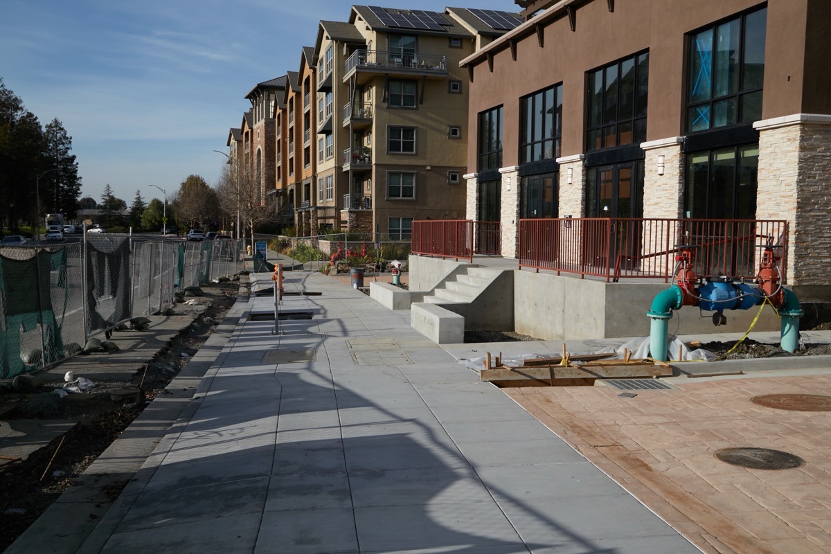
The driveway heading off to the right in the picture’s foreground is the one that cars will use to make their way to and from the building’s internal parking garage. There is a second driveway, just barely visible between the building in the foreground and the one in the background, that is really just for emergency access: if there is a major incident, that drive enables a fire truck to get to the remaining two sides of the building:

Other than for emergency or maintenance purposes, that second driveway will largely be a public and private pedestrian access to the creekside and to the segment of creek trail that is being built between the building and the creek:

Once I got to the other side of the freeway though, and crossed over Redwood Creek using the Bridge to Nowhere, I of course checked in on the county’s Navigation Center project. That project is now expected to be completed in mid-March: just five or six weeks from today. With the two outer stacks of residential units in place, the portable crane used to create those module stacks has been repositioned toward the center of the project, and has started putting modules there. On Wednesday I noted that some of the office modules had been put in place; by now, they’ve probably started placing the residential modules that will fill out the center of the development.

I’ve been writing about the Navigation Center project for some time now, and as it nears completion I was interested to see that the county has apparently decided to give me yet another reason to keep walking over to the east side of Highway 101: at the City Council’s January 23 meeting the county presented their vision for what they’d like to build on the (now) city-owned land at the end of Maple Street, where it dead-ends into Highway 101. Today, that is where you’ll find the LifeMoves Maple Street Shelter:

(Oddly, although I’ve been by this shelter countless times, I’ve apparently never taken a photo of it. Thus, the above image is thanks to Google Street View.)
My understanding is that once the Navigation Center has been completed, the residents of the LifeMoves shelter will be relocated to the nearby Navigation Center. Then, the old building you see in the above photograph will be demolished. After setting aside room for the continuation of Blomquist Street (which will basically run right through the parking lot you see above, and which will be built by the folks who have constructed the Blomquist Street extension: the folks building the 131-unit townhouse project on the adjacent land along Redwood Creek), the city will be left with 1.5 acres of developable land. That land is where the county would like to build yet another housing project. This one would also be affordable, of course, but unlike the Navigation Center, which is meant for relatively short-term stays (short-term being some number of months), this would be long-term rental housing for those who fall into the Extremely Low Income category. (Extremely Low Income households are those earning less than 30% of the average income in San Mateo County which, currently, translates to less than $39,150 per year for an individual.)
Getting back to the location for a moment, during the presentation one of the presenters put up a nice slide showing the parcel highlighted on a map of the area:

I captured this image from the screen during the presentation; it is based on an old satellite photo that still shows the current LifeMoves shelter (in the area outlined in red) and also shows where the townhouses, which have not yet been built, will go. Note the freeway across the bottom of the image, Redwood Creek angling up along the left side, and Maple Street along the right (Maple makes a “U” off the top of the image and comes back down between the townhouse project property and the Navigation Center property). As you can see, the 1.5-acre parcel upon which the county would like to build the new affordable housing project would be close to the creek, although it would not be right on it. It would also be pretty close to the freeway.
The county is still in the thinking phase of the project, and thus there are no plans to explore. However, it has apparently signed an agreement with MidPen Housing to build and operate the new facility. A representative from MidPen showed a rough concept of what it is thinking when it comes to this project (given how early we are in the project process, the actual project may not look anything like what they showed). Their idea at this point is for a four-story, L-shaped building containing 108 studio apartments, each roughly 300 square feet in size. There would be a surface parking lot in the back, between the residential building and the townhouse project, acting as a bit of a buffer. There also would be a single-story building or two running diagonally across the L that would contain a community room and offices for the folks from the county who would provide supporting services to the building’s residents.
The following image contains two renderings. The one on the left shows the current, very preliminary design as viewed from Highway 101. Note the multi-story L-shaped buildings (with the ghostly outlines of the townhouses behind), and the single-story amenities and services buildings along the street. The area between would be landscaped, giving the residents some fairly private outdoor space to enjoy.
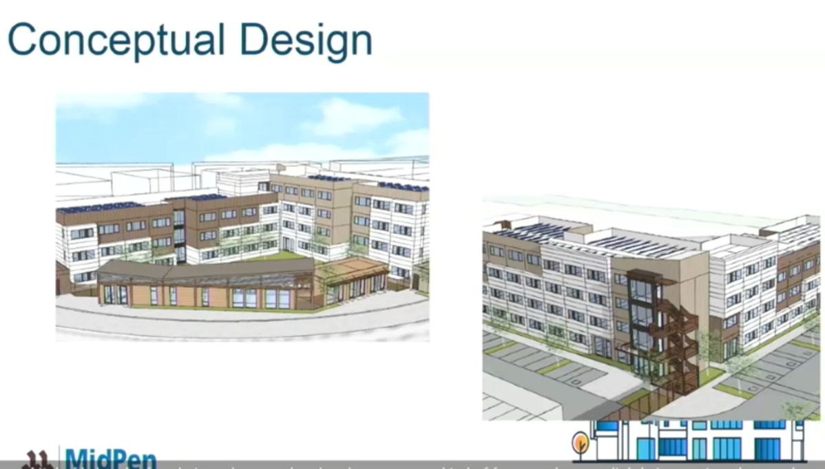
The image on the right shows the back side of the residential building, as viewed from above the townhouse project. It gives you some idea of where the parking lot would go. It also gives a hint to the fact that MidPen intends to put solar panels on the project’s roof, to help offset the power needed by this all-electric project.
I mentioned that in order to qualify for a space in this building, a resident must be earning less than 30% of the “Area Median Income” (an average of incomes in San Mateo County). MidPen, who has a lot of experience running projects like this in our area, is well aware that many of the residents will likely be earning much less. As for what it would cost to live here, residents are only obligated to pay 30% of whatever they earn. According to MidPen, that will work out to about $200 per month, on average. (Yes, you read that right. Just $200 per month, more or less, depending upon what the resident earns.)
Currently the county is working on assembling the funds for the project. The county itself has already committed $15 million, and they’ve received a personal commitment from John Sobrato for another $5 million. These two commitments mean that the county can apply to the state for additional funding, after which the county intends to use its Affordable Housing Fund to make up most of the remaining amount.
As for protection from sea-level rise, this parcel, like those where the townhouse project and the Navigation Center are being built, will be raised to a level of 14 feet above that of the creek. And finally, although this would be a county funded and managed project, because Redwood City owns the land (the county has an option for a 65-year lease), and because the parcel was called out in the city’s new Housing Element as a site for affordable housing, Redwood City will get to credit the 100+ extra-low-income housing units against its Regional Housing Needs Assessment (RHNA) goals. Which is nice for the city…
This is going to be an interesting project to watch. I for one hope it makes it to completion: this would be a good chunk of truly affordable housing for a segment of our population who desperately needs it. And it would be well positioned in an area that is rapidly filling with housing (and that just may get a park someday, on the handful of undeveloped acres that the city still owns over there). I can attest that it is an easy walk from this site to downtown Redwood City, and an even easier bike ride. And hopefully, with all three projects completed, SamTrans will wake up and realize that Redwood City needs better transit service on that side of the freeway. Then, given options to walk, ride, or take a bus, residents of all three developments would be able to easily get to jobs, stores, entertainment, and services without the use of a car, which is ideal.

Do you know if there will be a public open house for the navigation center?
Excellent question. I do not know, but I’ll ask around.
Thanks Greg. All of this affordable housing is exciting for our community. Too bad Atherton is having a difficult time building new housing even when the chosen spot is on the edge of Atherton right next to Redwood City!
On another topic, do you or any of your readers know what’s going on with the theaters? They are showing very few movies (and only in theaters 1-8) and it seems like they either flooded during the storms and are fixing it, are doing remodeling or both. The parking spots across from Box next to Arya have been closed off for weeks.
Thanks!
I noticed the closed-off parking spaces and saw that some sort of construction/repair work was going on, but no, I don’t know what that’s about. I’m afraid I haven’t set foot into a theater since COVID began (although I’m ready to go back!). Does anyone reading this know the answer to Sarah’s question?
I walked by the theaters the other day and noted that work continues. It finally occurred to me to check the building permits, and in doing so I got the answer you are looking for: it seems that the theaters are being upgraded, possibly to the high-end luxury theaters you see in some places. There are two permits, one for auditoriums 1-8, and then another for auditoriums 9-20 (the project will be done in phases), to change the theater seats from rockers to recliners. Given that the theaters that I’ve been in that have reclining seats also do food service (you order at your seat and they deliver during the movie), that *might* be what we are getting. But even just with the change of seats — which may mean fewer seats per theater, and may be reacting to the loss of theater-goers due to COVID-19, the project likely involves spacing out the seats more.
I’m certainly looking forward to seeing the result! Of course, since I’m doing a lot of speculating, don’t be surprised if the ticket prices go up as well…
Thanks Greg! The timing seemed like it was flooding but it sounds like it was all pre-planned. I have never done a movie with food service…it seems like it would be distracting.
> I have never done a movie with food service…it seems like it would be distracting.
I’ve done it, and it’s actually pretty nice. Whether we get that, though, we’ll have to see; I was of course just speculating. But I can see how theaters are going to have to figure out ways to entice more customers back through their doors, and upping their game just might do the trick.
> The timing seemed like it was flooding but it sounds like it was all pre-planned.
Indeed; they filed for the permits last August, and only received them at the end of the year (oddly, one permit was issued on December 21, and the other was issued on January 17). The rains may have delayed the work a bit, but they got the ball rolling on this project well before our weather turned cold and wet. In any case, I’m just glad that our downtown theaters are sticking around, and not giving up. I guess I’ll have to start going back to the movies from time-to-time, as a way to help keep them in business. 😎