
Before getting into today’s main topic, my wife and I headed to Bair Island last Saturday right at the peak of the king tide, and naturally I went prepared to take pictures. We periodically go walking out there to watch the birds, but usually the water level is low enough that the island is, well, mostly an island. This time, though, very little of the island itself showed above the level of the water:
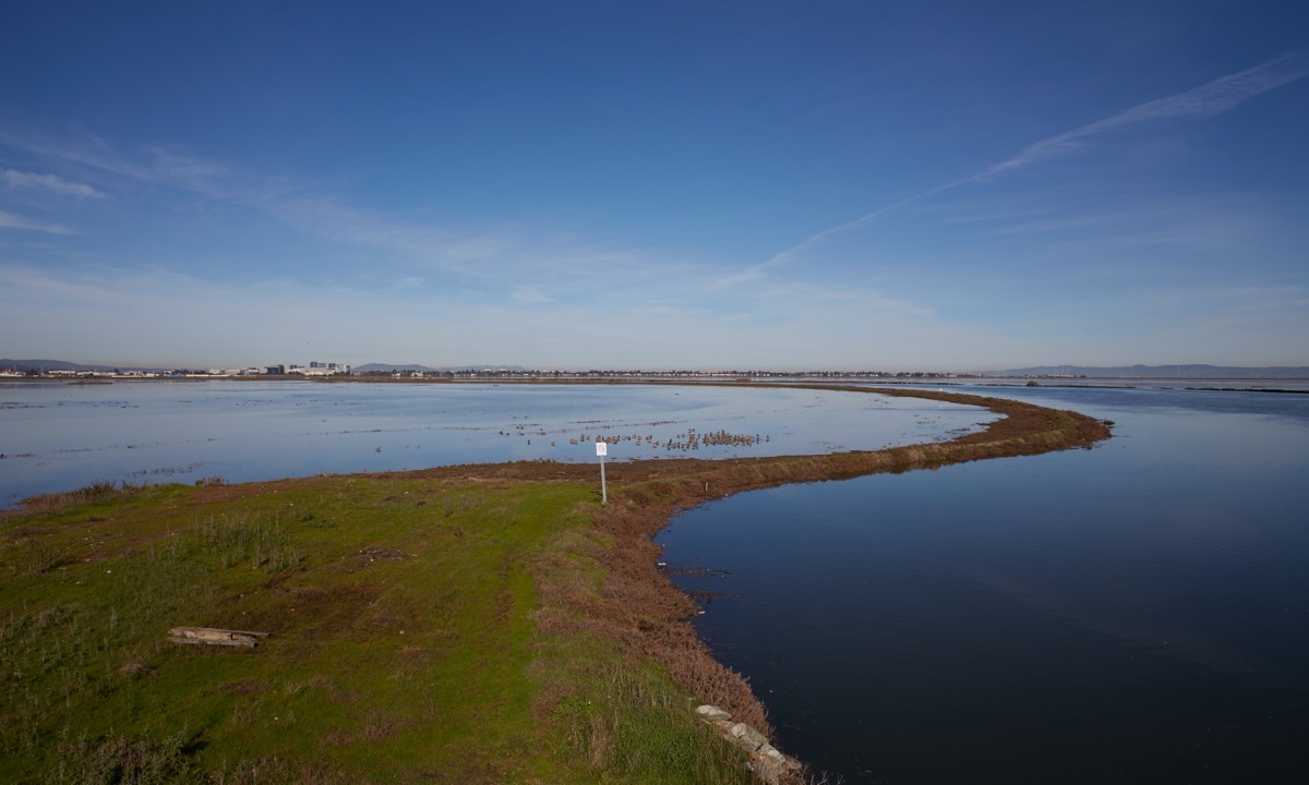
Not that the water was particularly deep in many spots, of course: we saw plenty of wading birds who clearly were standing in just a couple of inches of water. And the paths we were on were very much high and dry.
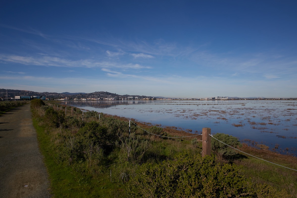
It sure was beautiful, though. I can highly recommend Bair Island as a place to take an easy, flat walk. Just cross over Highway 101 at Whipple Avenue, and follow the road past the car dealerships and the One Marina condominium complex. When you see the brown signs for the Don Edwards San Francisco Bay National Wildlife Refuge (of which Bair Island is a part), make a right turn into the parking lot (where you’ll also find public restrooms) and park. Then walk back out to the street, cross over, and make your way to the bridge that leads out onto the island. Go through the gate (it won’t be locked) and either turn right to take a very short walk, or turn left to take a much longer one. Both lead to raised observation platforms where you can get a terrific view of the surrounding wetlands. With the tide constantly going in and out, the plants and animals are always changing, and always provide something interesting to see.
On Wednesday, January 11, I was getting ready to make my way over to the downtown branch of the Redwood City Public Library when I discovered that the meeting I was planning to attend had been shifted to online, via Zoom. That was fine by me; I certainly don’t mind attending a presentation from the comfort of my own home. In any case, representatives from both the city and RRM Design Group, whom the city hired to develop a design for the park that will soon be located immediately adjacent to the downtown library, contributed to the presentation.
Note that, ultimately, the city hopes to create three connected parks in downtown Redwood City, each of which would likely address a different need. Thus, although this park will be built first, in the hopefully not too distant future people will be able to flow from this park through another located where the Main Street parking lot is today (behind City Hall) and then, via a clearly marked route, to a long, linear park that will line the sides of Redwood Creek and extend from Bradford Street out to Highway 101 and, via the underpass, beyond. That third park will likely be intended for enjoying nature and getting exercise, while the middle park’s purpose has yet to be clearly defined (although I can imagine that its focus might be on community gatherings).
The meeting I attended was focused on the library park, which has a handful of clearly defined goals. In addition to connecting this park to “other open spaces in downtown” (by which I presume they mean the other, future downtown parks), it also needs to connect it to the library itself, to provide spaces that the library can use for some of its programming. Then, because a good portion of the park will be located beside and even somewhat behind the library building itself, the designers were instructed to open up visibility to the area (currently, some large trees restrict visibility into “Rosselli Garden,” the grass area beside the library where much of the park will go) and to activate the space, meaning make it a place where a number of people will be playing, working, studying, and whatever. Making the space as easy to see into as possible and filling it with a range of people should transform that portion of the property from a place where, today, homeless folks and people engaged in questionable activities sometimes hang out, to one where everyone feels safe and welcome. Lastly, the designers were tasked with including a community gathering space, and making the park “compatible with downtown businesses and programming.”
Given all that, the designers came up with a long list of possible amenities for this new downtown park. But rather than presenting those amenities and getting feedback on each individually, they put together two possible park designs, each of which employs a number of those amenities. These designs make it much easier for those of us providing feedback to envision how many of the amenities might work together in a final design, and thus whether or not they are worthy of inclusion. Note that neither design was intended to be accepted as-is; they’ve been created primarily to help get the discussions going.
Before I present the two designs, allow me to first identify which portions of the open space around the library building are up for possible redevelopment. Basically, there are four: the open plaza in front of the library; Parking Lot A (the lot to the east of the library, at the corner of Main Street and Middlefield Road); Rosselli Garden; and, optionally, a portion of Parking Lot C, which stretches across the rear of the library building. The extent of the new park was shown during the presentation (in images created by RRM Design Group, as are all the renderings I’m including below); here is a portion of that image, with the majority of the park outlined in magenta and the optional portion (added by me) outlined in blue:

In total, the park will be roughly 1.5 acres in size.
What follows is the first of the two alternatives that were presented during the meeting. I should note that these images are taken from screen captures I took while the meeting was ongoing; larger, higher-quality images should be available in the lobby of the downtown library. But feel free to click on any of these images if you want to try to get a closer look.

In this alternative, the design adds a great deal of greenery to the library’s entry plaza, which should make it far more comfortable on a hot day. It turns Library Lot A into, essentially, a large green space with a permanent stage (in purple, at the end by the library) and, at the far end, a “teen hangout area” plus, at the intersection, a prominent entry into the park. Heading towards the rear, one passes an open area designed for teaching classes and giving small presentations, and, right up against the library building itself, an outdoor “maker space” to compliment the library’s existing indoor maker space. This outdoor maker space would be ideal for activities such as woodworking, which cannot be done within the library itself. Finally, the entire back portion of the park would be given over to a large play area for the younger set. Oh, and the trees you see running across the back of the library would shade a good portion of what would be a walking loop that would go around the perimeter of the library property.
There are numerous small details in this design, such as game tables, outdoor restrooms, a pet relief station, and, of course, a variety of seating areas.
Moving on to the second design, we see something similar:
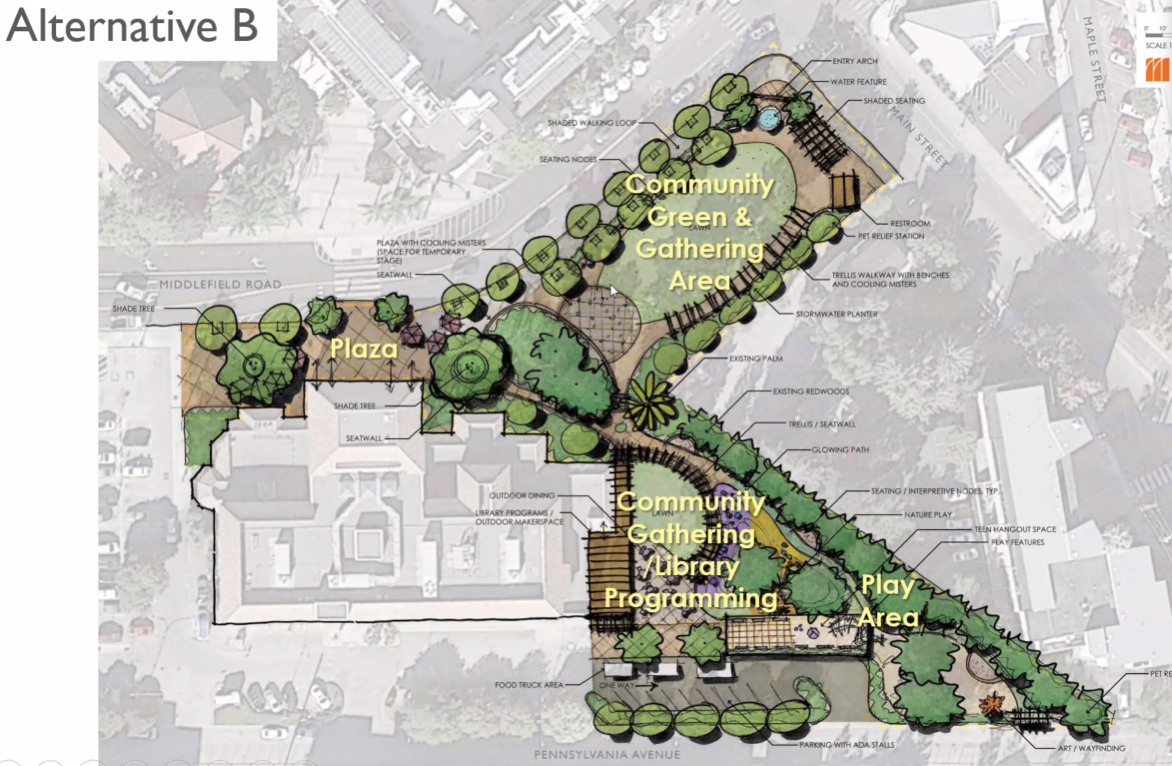
At a glance this design looks very much like the first, but it rearranges the location of some key elements and draws upon some different amenities from the list of possibilities. First, although the community green remains, the stage is no longer permanent. Instead, a temporary stage would be erected only when necessary (somewhat like what is done in Courthouse Square on concert nights, I imagine). Then, the teen hangout that in Alternative A is located out along Main Street has been relocated to the rear of the property, adjacent to the (smaller, in this design) kids play area. This design also doesn’t consume as much of the rear parking lot, leaving space for a “food truck area.”
In this alternative design, the area at the side of the library to be used for community gatherings and library programming is larger and is accompanied by a patio with tables and chairs. Many of the same details from the first alternative carry over here, though: a close look reveals restrooms, a pet relief station, and scattered seating areas. But for this alternative the designers have also added trellises with “cooling misters” and a water feature near the park entry at the intersection of Main Street and Middlefield Road; both would be very welcome on a hot day.
As I noted, the final park may well look like neither of these two alternatives, but instead may be constructed from pieces of both. For help with that final design, the city and the park designers are once again turning to us: they’ve put together an online survey that we members of the public can take to provide our feedback. I will admit that I should have written this post earlier, to give you more time: the survey closes this Tuesday, January 31. However, the survey doesn’t take long, and as you work through it they provide images (such as what I’ve shown here) and descriptive text that make fairly clear about what you are being asked. If you have the time, the entire meeting was recorded, and is available for public viewing; a link to that presentation and a link to the survey are both near the top of the web page devoted to the Downtown Parks and Bay Connectivity Project. But whether or not you watch the presentation, consider taking ten minutes or so to fill out the survey and thereby let the city know what you want in a downtown park adjacent to the public library.
Shifting gears, recently I’ve noticed two new food service options in Redwood City. I’ve only had a chance to try one of them, but in service of wanting to promote local businesses, I thought I’d mention them both here.
First is the one that I’ve actually had the opportunity to try: Aroma House Restaurant, in the small shopping center at the corner of Oak Knoll Drive and Canyon Road (where Bonfare Market and Sancho’s Taqueria are located).

This place aims to serves “high-grade Indian cuisine” and, although I don’t claim to be the best judge, the food my wife and I and our two friends had was very good indeed. While you can eat there, the decor struck me as being rather plain; we opted to simply order our food online and pick it up to eat at home. They do deliver, though, and they cater as well.
The other place I wanted to mention strikes me as very intriguing: California Bakeshop. I noticed their sign posted on an empty storefront at 2068 Broadway:
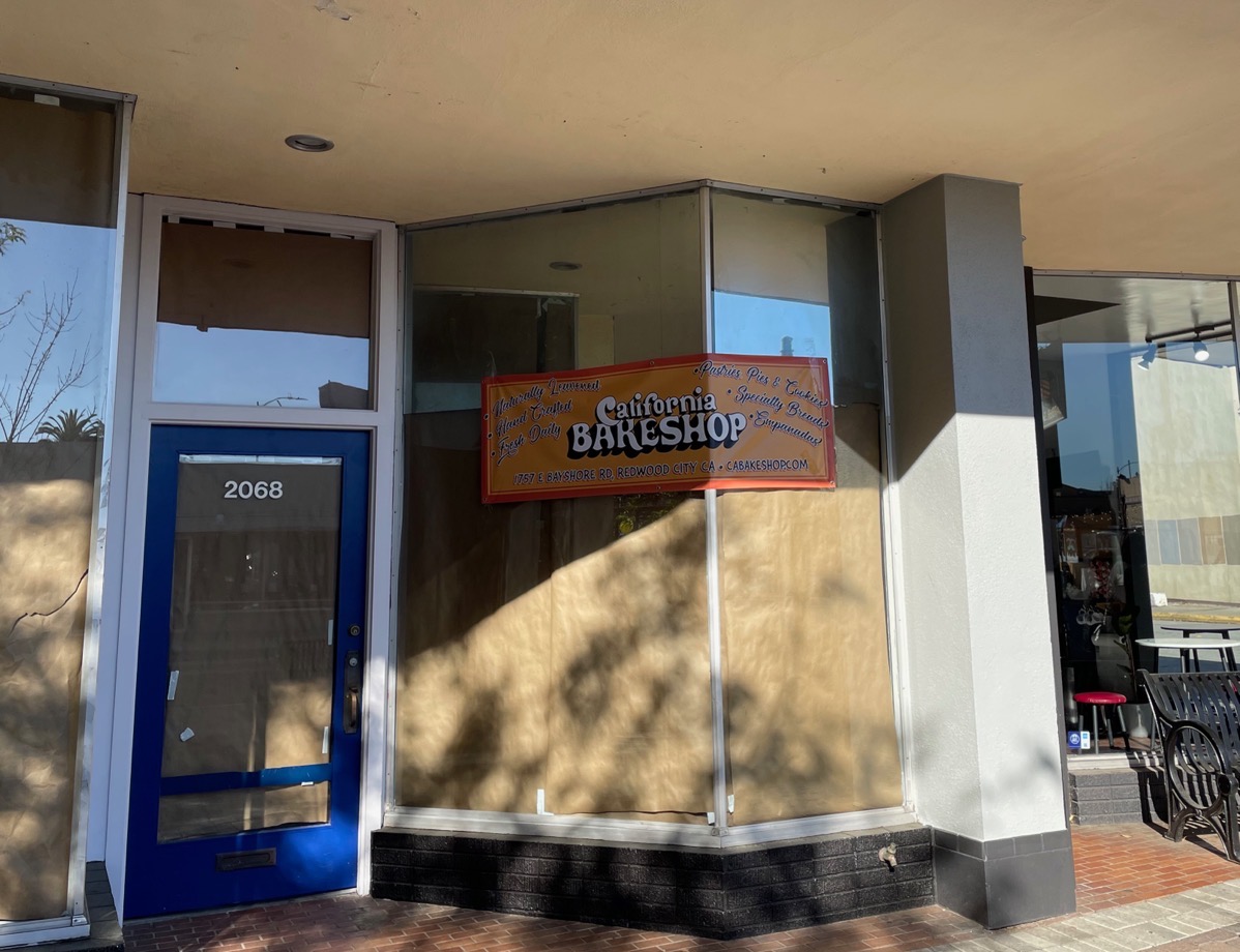
When they finally open their doors on Broadway, they’ll be selling pastries, pies, cookies, empanadas, and, most importantly, “naturally leavened, hand crafted, fresh daily” bread. Can’t wait? They’re actually already in business in Redwood City, making bread, cookies, and scones of a wide variety. You’ll find them at 1757 E. Bayshore Rd., just south of Woodside Road (well, Seaport Boulevard, technically) on the east side of Highway 101. Until their new store opens, you can view their offerings and order online, and then pick up your purchases there. Personally, I can’t wait to try some of their breads — they have a terrific selection (roasted garlic asiago loaf, anyone?).
That’ll about do it for this week’s post. I did take a long walk through Redwood City on Wednesday, both to enjoy our lovely weather and to of course gather intel, which I’ll report on in a future post. I do want to echo two items of importance from the city’s weekly online newsletter, though:
- Redwood City’s Planning Commission needs to fill two partial-term vacancies. Community members who are passionate about planning and development (you know who you are!) are encouraged to apply. If you want to know more about what the Planning Commission does, check out this blog post. And if you decide to apply, you’ll find the application form here.
- The Domini Hoskins Black History Museum & Learning Center will once again be celebrating Black History Month by coming to Redwood City. You’ll find them at the old Cost Plus World Market space at 890 Jefferson Ave. from February 3-28. They’ll be closed on Mondays, but open from 12-5 p.m. Tuesday through Sunday. Admission is $10 for adults and $5 for children under 12 and seniors 65 and older.

Pingback: Housing Extremes | Walking Redwood City