
Two of the major projects that may well be in Redwood City’s future made progress recently: the 1900 Broadway project was formally submitted to the city, and the developer behind the Sequoia Station revamp submitted a tweaked set of conceptual plans. And while all of that behind-the-scenes paperwork was crossing the desk of the Redwood City planning department, I saw signs that the Broadway Plaza project may soon be getting underway.
The 1900 Broadway project, as you may recall, is a proposed seven-story mixed-use building for the site where today Wells Fargo Bank has its downtown branch. As I reported last week, the ground-floor retail space within the four-story brick office building at the corner of Jefferson Avenue and Broadway — where the Chan Zuckerberg Initiative has its offices — is now being outfitted as a new downtown branch of Wells Fargo Bank. This is being done so that the stand-alone bank building currently at 1900 Broadway can be torn down, thus making way for the proposed new building. Of course, the 1900 Broadway project is very much in the proposal stage — the formal proposal was just submitted to the city a week or two ago — and so it’ll be some time before it is built (if it ever is; there are some major hurdles that need to be surmounted before it can hope to gain approval). If it is, though, and assuming it resembles the proposal that was recently submitted, it would look like the following, which shows what the building would look like if you were standing on top of the Sequoia Hotel:

The formal proposal closely mirrors the design that had previously been presented to the City Council as part of the Gatekeeper Process. I wrote about the project in some detail back in May; rather than repeat that information, I’ll simply refer you to that post, which was called Better Than Ever. There have been a few changes since May, though. For one, the amount of office space has increased slightly, to 228,000 square feet. For another, we now have a more concrete idea of the number of for-rent apartments that would make up the building’s top two floors: 71. Of those units, one would be a studio, and the remaining 70 would be a mix of one-, two-, and three-bedroom units. Oh, and the private lobby for the residences would be located on the Marshall Street side of the building (folks heading for the offices would do so through a lobby located off the public plaza you can see above). Previously, the housing was intended to be for those earning at the Low and Very Low income levels; now the developer seems to be designating all 71 apartments for those at the Moderate income level (which is for those earning between 100% and 120% of the Area Median Income, a figure that varies depending upon the number of people within the household).
One thing that has not changed is how traffic would be rerouted to accommodate this proposed building. The proposal, in fact, does not seem to address the issue at all, seemingly leaving that up to the Environmental Impact Report (EIR) and the city. In case you aren’t clear on what the issue is, here is a plan view of the project showing the streets as they would surround it:
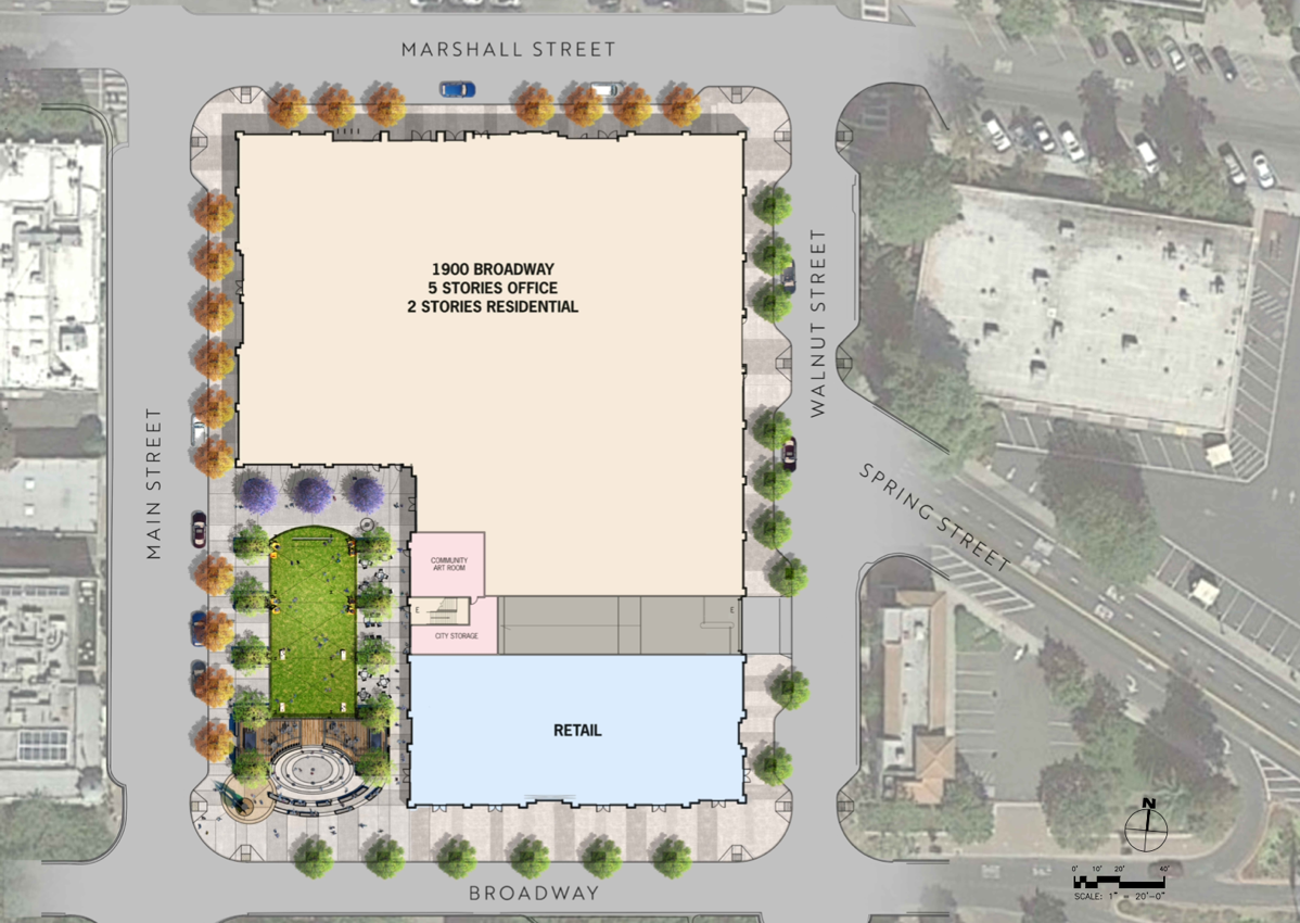
[click the image for a larger version]
Currently, the vast majority of cars heading east, say, on Marshall Street make the gentle transition to the angled Spring Street. But as you can see from the above, that one block of Spring Street that touches Marshall Street would be eliminated. Would they then turn right on Walnut Street and then left on Spring, thereby jogging around the building? Not likely, given that, as you can see, Walnut Street is quite narrow and indeed today is a northbound one-way street. Unless Walnut is reconfigured, it wouldn’t be legal to make a right turn onto Walnut from Marshall Street eastbound (as is true today). Traffic coming the other way — westbound up Spring Street — could turn right onto Walnut and then left onto Marshall, but I have to believe that Walnut is not configured for the volume of traffic that would result. Thus, another solution will have to be found. I’m a bit skeptical that the traffic engineers will be able to come up with something as smooth as the Marshall-Spring-Broadway connection we have today, but I’ll reserve judgement for now.
It will likely be months before this project comes before the Planning Commission and/or the City Council, and in the mean time I expect that the proposal may be altered to reflect concerns raised by city staff. So just consider this a first draft, although one that we should all examine closely.
Moving on to the Sequoia Station project, the latest proposal is only slightly different from what the developer, Lowe, showed us back in May, when they formally submitted their project (I wrote about the project shortly thereafter; see my post One of These Days…). Again, I won’t repeat what I said back then, but wanted to point out the primary changes that have been made since May. In addition to providing additional detail, the latest submittal has one or two minor changes to the layout, the largest of which is probably the relocation of the flex/community space from its previous location, facing onto “Hamilton Plaza,” to a spot along Franklin Street near the childcare center. Some of the smaller retail spaces have shifted around to accommodate this move; there is now a bunch of retail along Hamilton Plaza where the flex/community space used to be.
Before I go any further, allow me to help orient you; this should simplify the discussions that follow. First off, here is a rendering of what the project site would look like from the air:

Quite a change, isn’t it? Anyway, El Camino Real is the street in front, with the trees along it. James Avenue runs along the left side of the six-building development, and Jefferson Avenue runs along the right side. Caltrain, of course, would run behind all of this and, as usual, separate the Sequoia Station property from downtown Redwood City.
Now, here is a plan view of the site:
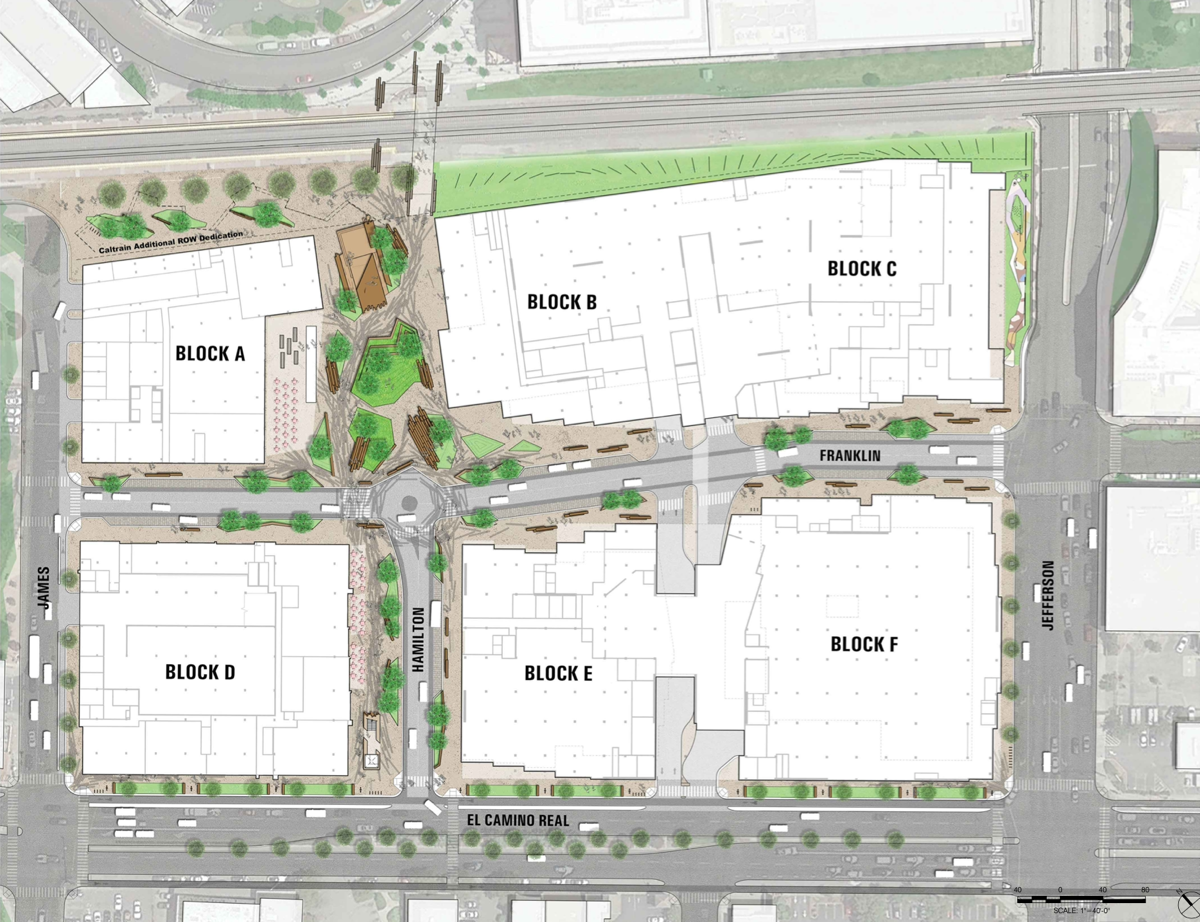
Here, the streets are labeled, although you’ll need to zoom in on the image in order to see them. What I really want you to see, however, are the labels on the buildings (or “blocks”) themselves; it’s easier if I can refer to the buildings by their block names. Across the back, from left-to-right, are blocks A, B, and C. Block A is a residential building, while blocks B and C are office buildings (all of the six buildings have some amount of retail on their ground floors, and Block C also includes a childcare center and the flex/community space). Blocks D, E, and F make up the row of buildings along El Camino Real (which runs along the bottom of the plan view), again from left-to-right. Block D is also a residential building, while blocks E and F are office buildings. Most importantly for most of us, though, is the fact that a good chunk of the ground floor of block E would be the new CVS drug store, while pretty much the entire ground floor of block F, at the corner of El Camino Real and Jefferson Avenue, would be the new Safeway grocery store. Beneath pretty much the entire property (except for beneath the newly extended Franklin Street, which runs through the development from left to right) would be a large multi-level parking garage. Oh, and “Hamilton Plaza” is that space between blocks A and B.
One of the challenges that Lowe faces is to build all of this while keeping the existing Safeway and CVS stores open. They plan to do this by building the project in two phases, as detailed in the latest project submission. Basically, what they are proposing is to first tear down two of the existing center’s free-standing buildings, and build the block E and F buildings, all the while keeping the rest of the center as untouched as possible. Then, once CVS and Safeway have moved into their new digs in the base of those two new buildings, Lowe would tear down the rest of the center and build blocks A-D.
As for what we would lose during phase 1, we’re talking about these two buildings:

and

Thus, we’d lose Barnes & Noble, Pet Food Express (which shares the building with Barnes & Noble), Old Navy, and the Habit Burger Grill. I presume that none of these can relocate to another storefront within the existing Sequoia Station, although perhaps one can move into the free-standing building that formerly held Pier 1 Imports (and there of course is the old mattress store space next to CVS, although it is smaller). Whatever happens, I hope that both the city and the developer are working to keep these retailers somewhere in Redwood City.
Because parking would also be affected during construction, and because the underground garage extends beneath the block E and F buildings (where Safeway and CVS are to end up), the portion of the garage that would sit beneath those two blocks would also be constructed as part of phase 1. Here is an image showing the highest level of the underground garage for the whole development:

In the above, I added a green outline showing the portion of the project that would comprise phase 1. The rest — which of course is where most of the buildings that make up today’s Sequoia Station shopping center stand, wouldn’t be built until phase 2.
A possible change to the development’s parking is the other main highlight of the new submission. Although the developer is not committing to anything yet, the latest plans show that, in addition to the two levels of underground parking that were in the earlier design (the next level down looks very much like the above), there perhaps could be a third level, which would lie beneath only that portion of the garage between the newly extended Franklin Street and the Caltrain tracks. That is, it would be located only beneath blocks A, B, and C. But as I said, it is there only for discussion purposes at this time; the developer is not proposing that they build that third level (yet). For the record, though, the project design put forth in May had room for a maximum of 2,710 vehicles, while this new design, with the possible third level, would have as many as 3,177 parking spaces.
The Sequoia Station project was formally submitted to the city back in May, but it relies on a number of outside factors that will cause its approval process to take much longer than normal. Thus, don’t get too worked up about all of this quite yet; it’ll be years before anything happens to Sequoia Station, assuming it ever does.
Although Lowe is taking great pains to keep Safeway and CVS open, I should point out that there are other Safeway and CVS stores elsewhere in the city. There is a Safeway store on Woodside Road, and there is a CVS at the Broadway Plaza center at the corner of Broadway and Woodside Road. And much like with Sequoia Station, The Sobrato Organization, who is the developer behind the project to completely redo the Broadway Plaza property, has plans to relocate CVS before tearing down the existing store. (Need to come up to speed on the Broadway Plaza project? I wrote about it back in 2019, in my post Broadway by the Bay (Road).)
As you are undoubtedly aware, most of the shopping center that was Broadway Plaza was torn down some time ago, leaving only the CVS building still operating (the Denny’s and Jack-in-the-Box restaurants also continue to operate, but they are not part of the Broadway Plaza development). Sobrato has been working on utilities beneath the streets surrounding the Broadway Plaza property, presumably to ensure that all of the pipes and wires that will be needed by the three residential buildings and three office buildings (plus a bit of retail) that will make up the new development are in place before digging for the large underground parking garage begins. Not much else has happened on the property, though; so far it has primarily been used as a staging area for the materials and equipment needed to rework Broadway, plus Bay and Chestnut streets:

Although the Broadway Plaza site is keeping quiet, there is finally some activity on the other side of Woodside Road, on the property that will become the site of the new CVS store:

And according to the sign posted along Bay Road, Sobrato hopes to have this new CVS complete by next winter:

This new CVS needs to be up and running before Sobrato can tear down the old one, so this activity is a strong sign that work on the main site will begin soon. Since Sobrato also plans to build their project in phases, even with the existing CVS still open, then can get underway on the residential buildings that will be located along the Chestnut Street end of their property; I don’t expect to have to wait another year before work begins in earnest on that main site.
That about does it for this week, but for those who are feeling a bit overwhelmed right now, allow me to share with you Redwood City’s latest bit of public art:
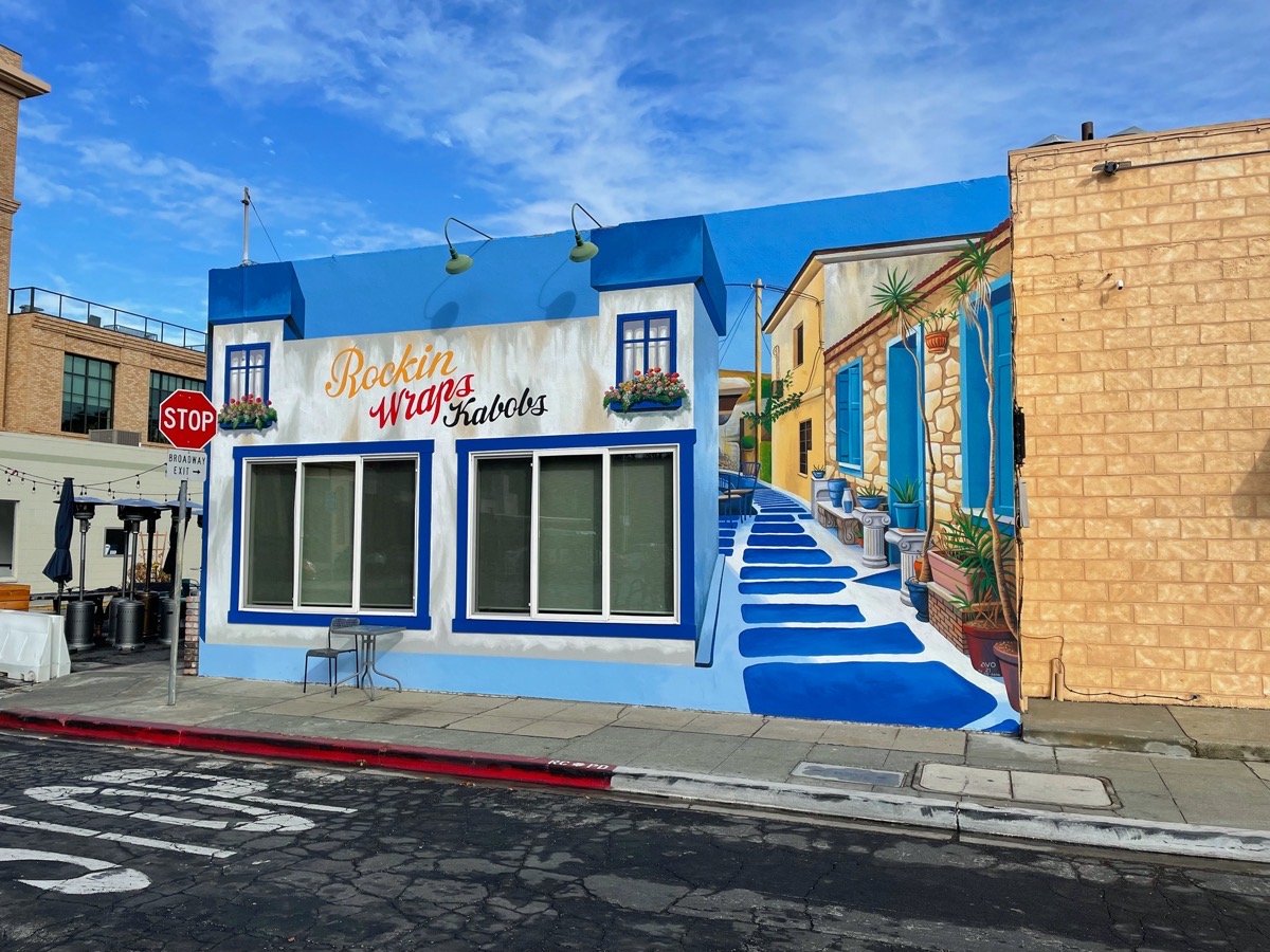
I say “public” because it is intended for all of us to enjoy (I took this picture while standing in the Main Street parking lot, just in from Broadway), although I’m sure that it was done at the behest of Rockn Wraps Kabobs [curiously, the mural calls it “Rockin Wraps Kabobs,” with an “i” in “Rockin” — but the business name uses “Rockn”], which of course is located within this building. While this mural is most likely intended primarily to call attention to their business, they did a terrific job. I love how they created a fake alleyway between their building and the one next door (home to Studio S, a dance studio); I want to walk down that walkway. And their clever use of a fake blue sky makes the Rockn Wraps building look shorter, and more interesting, than it actually is. Perhaps this will inspire the owner of the building just past Studio S where Zareen’s is located to do something similar; their back wall is just dying for a mural, don’t you think?

Have a great week, and stay dry. Hallelujah, the rain is here!

If the council allows 1900 Broadway to include Spring St in their lot, then I hope the council takes a closer look at the traffic issues on Walnut, as you have detailed. Walnut should be widened to be a 2-way 4 lane street between Broadway and Marshall, not just between Spring and Marshall. This would actually require them taking some land from the project’s eastern border and thus require the building to be narrowed just a bit. This would necessitate a revision to the project, at least that’s what it looks like in their rendering.
Thanks for this update! The reconfiguration of the streets around 1900 Broadway is discussed in the Downtown Precise Plan. Here’s what it says: “Broadway, from Walnut to Beech: At Maple, remove the channelization of traffic onto Spring Street and reconfigure into a standard 4-way
intersection, allowing westbound Broadway traffic to proceed into the heart of Downtown without impediments or confusion. Move the transition from 4 lanes to 2 lanes to the block between Cassia and Beech.” This might mean Spring St between Broadway and Walnut is also going to eventually disappear. Personally I’m excited about this change, and I think it’ll make this spot more pedestrian friendly, as it’s currently impossible to walk east-west along the north side of Broadway. The same document says that Walnut between Broadway and Marshall will be converted to 2-way traffic.