
Before I begin, I wanted to help spread the word: the waiting list for the 72-unit Hallmark House Apartments complex, at 531 Woodside Rd., is now open. Pre-applications are being accepted until midnight of March 1, 2021. The following day, a lottery will be used to select 72 entries from the many pre-qualified applicants who presumably will have applied. Note that the applicant’s total household income must not exceed 60% of the county median family income. For a single person, that upper limit currently is $73,080; for a couple it is $83,520; and for three people it is $93,960. (For all the numbers, see the 2020 San Mateo County Income Limits document [pdf]; note that this building falls under the HOME Limit, which can be found on the second page.) Also note that along with the application, prospective tenants must submit proof of income.
This building is being renovated after a disastrous fire gutted the building in late 2013. That renovation, which took years to really get going, is finally close to wrapping up. The units are now considered “all new”, and have private patios or balconies, walk-in closets, central heating and air, and electric kitchen appliances. The building includes covered parking, central laundry facilities, a swimming pool, and an on-site recreation room with kitchen. Its location is excellent: it basically sits at the corner of Woodside Road and Hudson Street (technically, Central Avenue, since Hudson changes names as it crosses Woodside Road). Safeway is just a couple of blocks away, as are a number of shops and restaurants. There is good bus service on Woodside Road and on El Camino Real, which is also only a couple of blocks away. Two great parks (Palm Park and Fleishman Park) are very close by.
The fire that took this building offline caused 72 low-income households to suddenly have to scramble for a place to live. It’s extremely unfortunate that it took this long to bring this much-needed affordable housing back onto the market, but, finally, we’re about there. If you qualify and are looking for a place to live, do check out Hallmark House Apartments. And if you know of anyone who falls into this category, by all means pass on the information. Simply direct people to HallmarkHouseApartments.com for more information and to apply.
As I mentioned in last week’s post, this week I wanted to talk about the Caltrain rail corridor through Redwood City, and the current thinking on how it may be upgraded to meet future demand. Exactly one year ago I wrote a blog post (Center Change) in which I presented some of the more interesting bits of the Redwood City Transit Center Redesign Study. That study, which the city had commissioned, was in response to Caltrain’s plans to accommodate their own plans to electrify their system (which will bring with it more trains), High Speed Rail (if it ever comes to pass), and the reactivation of the Dumbarton Rail Corridor (if that ever comes to pass). Since then, though, Caltrain’s plans have firmed up quite a bit: not only is electrification of the entire line making great progress, but Caltrain has also settled on its 2040 Long Range Service Vision, which defines the level of service they plan to provide by the year 2040 along with some of the ways they hope to implement that level of service. The main takeaway, for Redwood City at least, is that Caltrain essentially plans to double the number of trains running through our station each day. In order to enable this, they need to have four parallel sets of tracks at several key points along the line, to enable some bullet trains to bypass local trains, and to enable the easy transfer of passengers between other bullet trains and local trains. One of those four-track segments would be at the Redwood City station, doubling the number of tracks we have there today.
Upgrading from two sets of tracks to four complicates things quite a bit. For one thing, Caltrain needs room to lay these extra tracks, and currently there are a number of buildings standing close by that would have to be moved or altered. Indeed, Caltrain has already been working to claim additional right-of-way: witness the complete rebuilding of the Burger King at El Camino Real and Hopkins Ave., which shifted the building and its drive-through away from the tracks, freeing up room for Caltrain to expand behind that particular property. And next door, although the old Honda Redwood City buildings weren’t actually located on this expanded right-of-way, when the Link 33 condominium project, which is being built on the former site of Honda Redwood City, was designed, the buildings were placed so as to leave that right-of-way free.
Likely of more interest to some, providing Caltrain with additional right-of-way is one of the key factors motivating the redesign of Sequoia Station. The Sequoia Station shopping center is currently located very close to the tracks:

Although from the above picture it might seem as if the additional right-of-way could be obtained by moving streets and sidewalks, just out of the frame to the left are the Box buildings, and just out of the frame to the right are a number of small commercial buildings — all of which are close to the tracks on their side. Fortunately, Sequoia Station was already being considered for a major redevelopment. Accordingly, that project is being designed so as to free up the needed right-of-way.
Upgrading to four sets of tracks has other impacts beyond just requiring additional right-of-way. As I understand it, level crossings — which is where a road crosses the tracks at the same level, and thus requires crossing gates and such to keep cars (and cyclists and pedestrians) safe when a train is approaching — are not allowed if there are more than two sets of tracks. So, for example, here is where Broadway crosses the tracks today:

You can’t just add extra tracks here while maintaining a level crossing. Instead, the tracks and the road would have to be separated (vertically, as is the case at Jefferson Avenue), or the road would have to be blocked off altogether.
Those of you who have lived in the area for a long time undoubtedly remember when Jefferson was lowered to run beneath the Caltrain tracks. That was not an insignificant project. Then, we got to witness San Carlos agonizing about their grade separation projects. I recall lots of concern about how elevating the tracks would split that city in two, creating a virtual wall running the length of the city atop which the Caltrain tracks run. That project was an enormous and controversial one, and although I don’t hear as much overt complaining about the project now, it did indeed seem to split the city in two. For all the downsides, though, at least San Carlos doesn’t have to worry about collisions between trains and cars or bikes, as Redwood City still does. Traffic can flow without concern for the rail traffic there, unlike in Redwood City, where we often seem to find ourselves sitting at a crossing, waiting for a train.
If Caltrain truly does double the amount of traffic on its tracks, we’re going to spend a lot more time waiting for trains unless something is done. Plus, if the High-Speed Rail project ever actually starts running to San Francisco (something I have serious doubts about), there will be even more trains on Redwood City’s tracks. And then there is the Dumbarton rail project, which conceivably could add a few more, at least to a couple of our intersections. All of this adds up to an inescapable conclusion: some or all of our current level crossings are going to have to be “grade separated” — either the tracks are going to have to be elevated, the roads are going to have to be lowered, or both. And that is where Redwood City’s Transit Planning and Grade Separation Study comes in.
When I wrote about this stuff a year ago, the city was looking at a single, very preliminary, proposal. Since then, that proposal has been greatly expanded, to where there are now four alternative designs, with some of them having optional components. All of them are based on the supposition that the transit center, which is currently located next door to the Sequoia Station shopping center, would be shifted north one block. It would be located between Broadway and Brewster Avenue, where today Caltrain has a commuter parking lot. Where they vary is in how and where the tracks are raised, and where and how the roads are separated from the tracks.
For those wanting to explore the options in depth, Redwood City has constructed an on-line “virtual open house” (at http://www.rwctransitplan.com) in which you can explore how each of the designs would affect each major intersection. The “virtual open house” opens to look something like this:

By clicking on the room’s “walls” you can watch videos, participate in meetings, download documents, and even take surveys and provide feedback. You can scroll around the room and focus in on the various elements. Of particular interest is the large virtual table upon which there is an overhead image of the Caltrain line as it runs through Redwood City. Important intersections from Whipple Avenue to Chestnut Street are marked with tags that you can click to find out more about how that intersection would be affected in each of the four designs.
Here is a better view of that table:
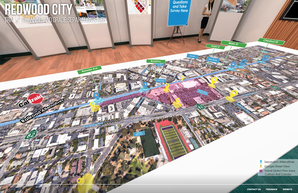
The clearly visible sports fields of Sequoia High School help with orientation. Above them, the central area shaded in pink is today’s Sequoia Station shopping center, along with the current transit center (the triangular bit to the left of Sequoia Station) and the planned location for the new transit center (the long pink arm running between Brewster and Broadway, along the tracks and to the left of the current transit center).
In addition to the relocation of Redwood City’s transit center, all four designs assume that the two tracks would split into four somewhere between Whipple Avenue and Brewster Street, and then would merge back to two somewhere between Broadway and Maple Street. Thus, crossing Whipple there would only be two sets of tracks, as would be the case when crossing Maple. But the Brewster and Broadway crossings would both involve four parallel sets of tracks.
As I understand it, here is a brief summary of the four designs:
Alternative 1: Coming south from San Carlos, the tracks would rise to a height of 24 feet above Whipple Avenue, which would remain at grade level. The tracks would remain at this height past Broadway, at which point they would start to come down. At Maple Street, the tracks would be 16 feet above grade, while at Chestnut Street they would be six feet above grade level. Brewster and Broadway would remain at grade level; as with Whipple they would simply pass straight beneath the elevated tracks. Maple Street would either be lowered somewhat (since the tracks have started to come down here) or it would be closed altogether to cars, with a tunnel providing grade-level access to bicycles and pedestrians. Main Street would be lowered to enable cars to pass beneath the tracks, and Elm Street would likely be closed at Main. Chestnut would also either be lowered significantly or closed altogether, with a tunnel allowing pedestrians and cyclists to still cross.
Alternative 2: This design is similar to Alternative 1. Coming south from San Carlos, the tracks would rise to a height of 24 feet above Whipple Avenue, which would remain at grade level. The tracks would remain at this height past Broadway, at which point they would start to come down. At Maple Street, the tracks would be eight feet above grade (versus 16 feet with Alternative 1), while at Chestnut Street they would be six feet above grade level. Brewster would remain at grade level, but Broadway would be lowered about four feet. Maple Street would either be lowered somewhat (since the tracks have started to come down here) or it would be closed altogether to cars (a tunnel would continue to provide grade-level access to bicycles and pedestrians). Main Street would be lowered to enable cars to pass beneath the tracks, and Elm Street would likely be closed at Main. Chestnut would also either be lowered significantly, or closed altogether, with a tunnel allowing pedestrians and cyclists to still cross.
Alternative 3: Coming south from San Carlos, the tracks would rise to a height of 24 feet above Whipple Avenue, but would then immediately begin to drop back down. They would be 16 feet above grade at Brewster, and 10 feet above Broadway. They would then rise back to a height of 16 feet to cross Maple before dropping down to six feet above grade at Chestnut Street. Brewster would be lowered to slip beneath the tracks. Broadway would either be lowered or closed to cars (with the requisite tunnel for cyclists and pedestrians). Maple, too, would either be lowered or closed to cars (with a tunnel…you get the picture). Main Street would be lowered, and Elm Street would likely be closed at Main. Chestnut would be lowered or closed to cars (also with a tunnel…).
Alternative 4: This is the simplest, and likely cheapest, option, but the one that would impact traffic the most. Heading south, the tracks would rise to 11 feet at Whipple, with the road lowered to fit beneath. The tracks would then drop down to grade level. Brewster would be closed completely, with bicycles and pedestrians having to divert to Broadway. Broadway would also be closed to cars, but would have a tunnel for cyclists and pedestrians. Maple, Main, and Chestnut would remain as-is, and at-grade — but would suffer from the increased number of trains passing through those intersections. Whipple and Jefferson would undoubtedly see a marked increase in traffic due to the close of both Broadway and Brewster Street.
In the first three alternatives, all of which have the tracks elevated as they pass by Sequoia Station, there undoubtedly would be a tunnel allowing pedestrians and cyclists to transit between downtown Redwood City and Sequoia Station. Plus, the tracks would also have to be elevated as they pass over Jefferson. This means that Jefferson, which currently drops quite a way down in order to pass beneath the tracks, may get flattened out somewhat.
All of these alternatives would require additional right-of-way. Lowering streets to pass beneath the somewhat-elevated tracks would affect buildings along those streets. Thus, the number of properties that would have to be purchased and razed in order to upgrade our Caltrain tracks would vary greatly depending upon the alternative chosen, and whether or not certain streets are closed. Alternative 4 requires the least amount of additional land, but it still would likely require the purchase of the Ben Franks property (plus one or two parcels to the north), some of the Infiniti dealership immediately south of Whipple, the Any Mountain building east of the tracks at Whipple, the SamTrans yard north of Brewster, and the A-1 Rentals building at Broadway by the existing transit center. The other options have more extensive lists of properties that may need to be acquired:
Alternative 1: Ben Franks (and properties north), some or all of the Infiniti dealership, the SamTrans yard at Brewster, the former Ghostwood Brewing building and the small building immediately behind it, the A-1 Party Rentals building at Broadway, the currently empty body shop building at Maple Street, the small building right at the corner of Main & Elm (but only if Elm is not closed), the Main Street Dog Agility Park, the Wings Learning Center building on Heller Street, a small apartment building on the north side of Chestnut Street, and an industrial building on the south side of Chestnut Street.
Alternative 2: Ben Franks (and properties north), some or all of the Infiniti dealership, the SamTrans yard at Brewster, the former Ghostwood Brewing building and the small building immediately behind it, the A-1 Party Rentals building at Broadway, the currently empty body shop building at Maple Street, the small building right at the corner of Main & Elm (but only if Elm is not closed), the Main Street Dog Agility Park, and the Wings Learning Center building on Heller Street.
Alternative 3: Ben Franks (and properties north), some or all of the Infiniti dealership, the SamTrans yard at Brewster, and the former Ghostwood Brewing building and the small building immediately behind it. At Broadway, the impact depends upon whether or not Broadway is closed to cars: if it is, no properties are needed here. If Broadway is to remain open, however, we might say goodbye to the A-1 Party Rentals building, plus half of the buildings on the south side of Broadway between California and El Camino Real (including Gourmet Haus Staudt), and a little less than half of the buildings on the north side of Broadway between Perry Street and El Camino Real (that’s Peet’s Coffee and others). Continuing on, at Maple we’d lose the currently empty body shop building on Main just south of Maple, plus the small building right at the corner of Main & Elm (but only if Elm is not closed), the Main Street Dog Agility Park, and the Wings Learning Center building on Heller Street.
Phew! As you can see, all of these alternatives are going to require a number of properties to be purchased (say goodbye to the Ben Franks building no matter which is chosen, for instance). When choosing — I believe that it is up to the City Council to make the final choice — I suspect that Alternative 3, with the option of leaving Broadway open, would quickly be eliminated due to the tremendous impact (and associated cost) it would have on Broadway. But of course when making that choice the Council won’t just be looking at the impact to neighboring properties. They will also be looking at the impact to local traffic and the overall costs, which surely vary widely from one alternative to the other. All in all, this is going to be a difficult choice.
As to when this might all happen, assuming that it does happen, Caltrain hopes to “deliver” (that is, complete) the project in seven to ten years from now, with construction getting underway in five to six years. Between now and then, choices will be made, plans will be drawn up, and funds — possibly in the billions of dollars — will hopefully be located.
Have questions? The best place to get them answered is at an upcoming Question-and-Answer session being held at 5 p.m on Wednesday, February 3, over Zoom. Note that two Q&A sessions have already been held, at least one of which is currently available in the Virtual Open House. That is also where you’ll find a link to the February 3 Zoom meeting, incidentally. Just check out the wall displays.
This week I spent some time exploring the future Dumbarton Rail line, from where it branches off the Caltrain tracks (almost behind the Redwood City Costco store, as it turns out) to where it approaches the badly damaged bridge that crosses the bay (just south of the Dumbarton Bridge). I had hoped to say something about that line in this week’s post, but clearly I’ve gone on long enough. I’ll save it for another time, shall I?

Thank you for yet another interesting read!! I think we need to look down the road of years in which we may not even still be here – for getting this right the first time!! Make the grade separations – less horn noise (although I love to hear the freighters), way less accidents & fatalities & with more trains – no wait times for vehicles, peds and cyclists!! Good links to lots of info in this article! 🙂
As Atherton did at its Fair Oaks Lane crossing some years ago, and whether the railroads like it or not, cities and/or counties have the right, solely at their choice and expense, to legally eliminate routine use of train horns by following and complying with the California PUC and Federal Railroad Administration rules and procedures for establishing “train horn quiet zones.” (Google it for more information!)
Once formally established and approved, the normal legal requirement to sound the horn 4 times in a prescribed pattern when approaching crossings no longer applies; the horn may only be used for a good cause (e.g. as it is with auto drivers, in the presence of some sort of potential or actual hazard).
Fully (vs. partially) elevated tracks providing the 15.5-foot vehicle clearance standard for streets passing underneath greatly reduce or eliminate the need to condemn and/or acquire nearby properties.
Existing streets & sidewalks and new activated spaces connecting east and west underneath stay at ground level, avoiding costly excavation and utility relocation to dip them down as with the relatively ugly bike/pedestrian-unfriendl “Caltrans-aesthetic” Jefferson underpass. As an added bonus, a fully elevated viaduct, getting the tracks and trains completely up and out of the way, allows the Jefferson under-crossing to be restored to ground level … which would also allow the restoration of the missing crosswalks at both Franklin and Middlefield. The new cross-town connectivity (e.g. between Sequoia Station and downtown and all along its length) and uses that a fully-elevated viaduct would enable are a truly exciting value-added opportunity (vs. a solid berm or wall as across San Carlos & Belmont).
I have recently this week confirmed with Brian Fitzpatrick, Caltrain’s property manager, that Caltrain would be delighted to entertain and be supportive of such a design. Sadly, it appears the city has not (yet!) directed AECOM, its grade separation alternatives engineering consultant, to design and include such an alternative. Happily, it’s still not too late to do so!
Lastly, for a deep dive for train/transit wonks and planners, I’d urge a careful and thoughtful reading of the following recent blog post “Redwood City Grade Seps: We Must Do Better”
https://caltrain-hsr.blogspot.com/2020/12/redwood-city-grade-seps-we-must-do.html
Thanks to the blog link! I found it interesting and ideas should be included in the City’s proposal.
Some excellent visual examples of activating the newly-created space underneath tracks of Caltrain-like commuter rail that has been fully-elevated in order to eliminate grade separations through suburban Melbourne cities (similar to Caltrain through Redwood City):
Caulfield to Dandenong Level Crossing Removal Project Overview
How Caulfield to Dandenong is Elevating Outcomes for Melbourne Communities
We can and should study doing the same here … the time is now! … as part of the ongoing city-sponsored grade separation study which has thus far FAILED to study such alternatives!
I like how you are thinking! I’m very surprised that the designs don’t think through embankments vs. bridge-like solutions. It feels like that choice would make a huge difference in terms of visual impact, cross-track traffic, etc. The “fully elevated” options seem to have language that negatively mentions their visual impact, but I’d personally prefer a fully-elevated solution that was on pylons vs. any sort of embankment.
Great to many choices to comprehend. Thanks for another great article
Great write up! I always wondered why Greystar didn’t try to incorporate those small parcels on the corner of Main and Elm into their giant South Main project…now I know why! Seems like some combination of Alt 1 or 2 is the way to go, though I’ve yet look over the 2040 vision plan. Hopefully they’d be able to accommodate the dog park somewhere nearby…Perhaps in whatever space left over from acquiring the Wings Learning center parcel.
You bet! Good idea. I’ve put it on the list…
Thank you!
Thanks for all of the information. I wonder if you could do some future columns about some pleasant walks in Redwood City? During the pandemic, it would be nice to have such a resource.