
lChLast week I mentioned the creation of the new Youth Mural Art Alley, in the small, little-known alley that runs along the side of the Sequoia Hotel between Main Street and the Main Street parking lot. At that time I could only speculate about what the art would look like, since although the alley had been created and metal poles to which the art was to be mounted were in place, the art itself was not yet there. This week I went back, and was delighted to see that the art has now been installed. I was also able to visit the site at night and see what it looked like in the dark — and I can attest that the “bistro lights” that are strung up along the alley do a great job not only of making the alley a friendly, safe-seeming place, but also of illuminating the art itself; you can walk the alley and admire each of the works in turn, day or night.
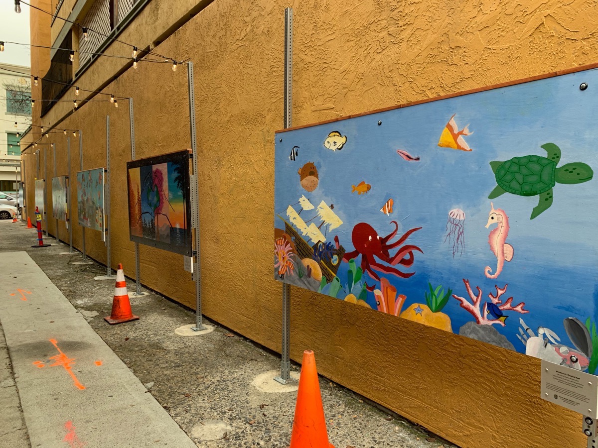
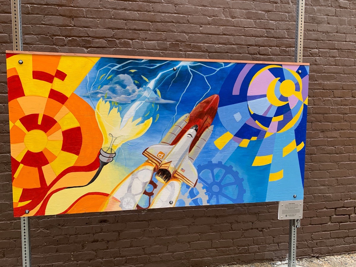
And those artworks certainly are worth admiring. Each of the ten murals is painted on a 4×8 sheet of plywood, and they are quite varied. Each has been created by a different group of youth — many from local schools — and each has its own unique theme and style. From the environment to space to one that is themed after what I presume is an imaginary video game, they are all lovely and well worth spending some time enjoying. I hesitate to call out any one work of art in particular — each has something to recommend it — but just so you know what I’m talking about, here is one that was created by students at Design Tech High School (on the Oracle campus in Redwood Shores):
You can visit the alley at pretty much any time, but if you are able you may want to attend the official grand opening, which is scheduled to take place this Sunday, January 26, at 4 p.m. I’m pretty sure that’ll not only will you be able to view the artworks, you’ll also get to meet some of the artists.
It isn’t art in the sense that most people would think of it, but I consider landscaping to be a form of art, and I have to say that I just love what the county has done with some of the new landscaping at our County Center. Take a look at this:
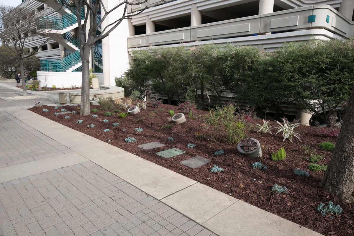
Although I like the plants, I was particularly drawn to the round concrete “planters” embedded in these beds. Here is a closer look at a bed elsewhere along this main walkway:
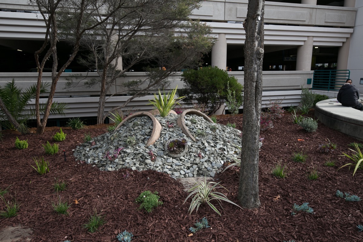
If you haven’t guessed by now, those planters are old concrete ashtrays and trash containers. What a cool way to reuse some old, outdated containers. I don’t know if the county has outlawed smoking within the County Center, but they at least see to be discouraging it by getting rid of those unsightly concrete ashtrays, and doing so in a very clever way. Congratulations to whomever came up with this idea; it’s a great one.
As long as I’m covering relatively small items, I thought I should mention that the August Barbershop at 707 Winslow St. (near the Hall of Justice) now has a coffee and tea bar at the back. I guess you can get a haircut and a cup of coffee here all at once…
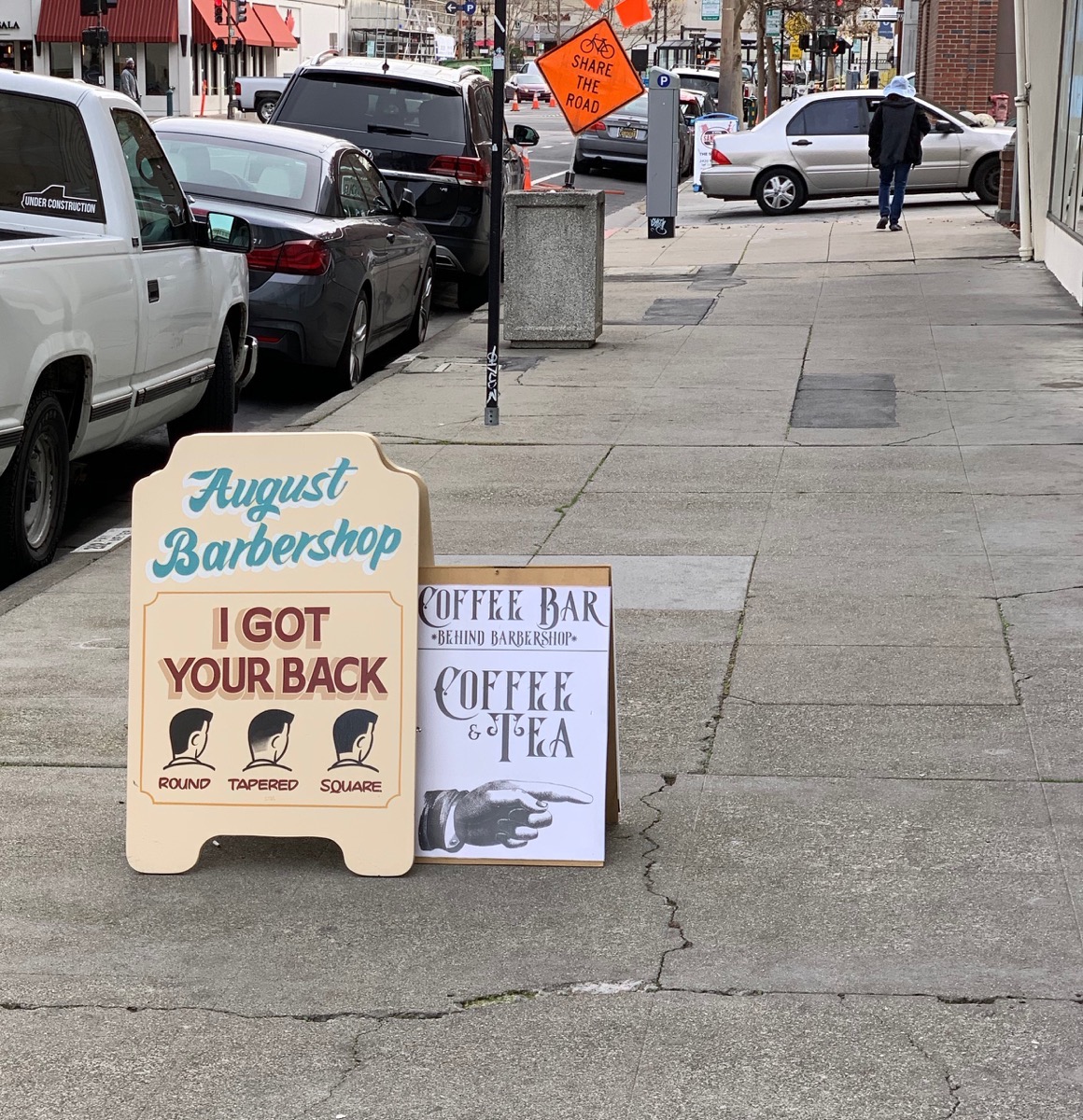
Its always interesting to see the different things that businesses do to draw in more customers in this somewhat challenging economy.
Ask and ye shall receive, at least sometimes. Last week I mentioned that Nam Vietnamese Brasserie is coming to 917 Main St., the former home of The Striped Pig. I also mentioned that although they have a website, they don’t yet have a menu posted, so other than assuming that the food would be Vietnamese, I wasn’t sure just what we are getting. Thanks to the ever-watchful Elena Kadvany over at Palo Alto Online, however, we now know that not only will this be a reasonably priced Vietnamese noodle bar, it is being brought to us by none other than Anne Le Ziblatt, who created the wonderful Tamarine in Palo Alto (as well as Bong Su in San Francisco — although I never made it to that one). I was interested in visiting Nam Vietnamese Brasserie before, but having read Elena’s article I’m really excited now. Apparently it will be opening in mid to late February; watch for it!
And now for something completely different (RIP, Terry Jones). Redwood City, as you may know, is considering reworking its transit center. There are a number of reasons for this, but in the short term they mostly boil down to wanting to encourage more people to use transit (and thus reduce traffic and help improve our air quality). In the long term, a reworked transit center will be needed to accommodate Caltrain electrification (which will bring with it more trains), High Speed Rail (if it ever comes to pass), and the reactivation of the Dumbarton Rail Corridor (if that ever comes to pass). Any or all of these will result in more, and possibly longer, trains stopping in Redwood City, which would put a real strain on an already busy transit center. Back in 2016 the city hired CDM Smith — a “global privately owned engineering and construction firm providing legendary client service and smart solutions in water, environment, transportation, energy and facilities” — to analyze our situation and present some ideas for how the city might accommodate its transit future. Last October they completed a draft summary report of their Redwood City Transit Center Redesign Study, and naturally, being a bit of a transit geek in addition to being deeply interested in Redwood City in general, I had to read it.
The report is only 24 pages, but there is a lot to it. I’m going to jump to the juicy parts, and show you what CDM Smith recommend that we do with our transit center (note that these are just ideas; it’s way too early to say what the city will actually do here, if anything). I think that there is a lot of sense in their recommendation that the city have two plans: a short-term one, and a long-term one. In the short term, they are suggesting some relatively simple, relatively inexpensive changes to our existing transit center that would not only make it more functional, but would also make it more accessible yet also safer for pedestrians making their way to and through the center. Here is a rendering from their report of what they envision these short-term changes to look like when implemented:
![]()
Currently, our transit center consists of a three parallel lanes for buses, plus a fair amount of parking. There is essentially no greenery there; it is all concrete and asphalt. Certainly the above rendering looks more inviting, with its trees and central park-like area. By trading those parallels bus bays for this circular arrangement, not only would we get an attractive center island that could serve as a park or house a bike station or snack bar, buses would no longer have to make the handful of tight turns that they must make today in order to get in and out of Redwood City’s transit center. This new design reduces some of the confusion that bus riders currently experience when trying to figure out where to board, and reduces potential conflict points between pedestrians and buses, greatly improving safety.
This design would reduce the parking lot portion of the center from 90 spaces to 40. However, the study determined that the parking garage beneath Sequoia Station and the Caltrain lot just north of Broadway are both significantly underutilized, and together could easily accommodate the loss.
Additional short-term improvements would include improved signage to better direct people to the transit center and the removal of the fences between the northbound Caltrain platform and Winslow Street, thus simplifying how pedestrians move between the platform and downtown Redwood City.
Long term, CDM Smith presented two options, one that utilizes the space currently occupied by the transit center, and one that shifts the transit center less than one block north. Because the study was performed starting back in 2016 — back when impacts from High Speed Rail were still difficult to quantify, and back when the Dumbarton Rail project was little more than a pipe dream — some of the long term plans presented in the report are already out of date. In particular, during the presentation of the report to the City Council it was noted that the long-term option of using the existing transit center space was probably no longer viable, and thus the city should really be focusing on the option in which the transit center is relocated.
CDM Smith suggests that the center be relocated from its current position, just south of Broadway, to the location of the Caltrain lot just north of Broadway. This relocated location is close enough to the existing one that it shouldn’t really affect anyone’s daily commute. Since the bus depot and the train depot would move as one, transfers between the two would be no more difficult (and in some ways they would be easier, given the relocated center’s more straightforward design). Here is a rendering showing CDM Smith’s vision for a relocated Redwood City Transit Center:
![]()
For purposes of orientation, this rendering is shown from the east side of the tracks. Broadway is the angled street towards the left side of the rendering, El Camino is just barely visible along the top edge, and the street along the right side of the rendering is Brewster Avenue.
In their vision, Perry Street — which parallels the Caltrain tracks between Broadway and Brewster Avenue — would largely be closed off to private vehicles (all except for the short bit between Broadway and Commercial Way, which runs behind the buildings that face Broadway on the north side) and turned into a long, linear one-way bus depot with bus bays along either side. The Caltrain station would of course be located alongside the tracks here — but note that there are four sets of tracks in the rendering, rather than today’s two. This is to accommodate what will be needed if High Speed Rail comes to pass: the folks behind that effort seem to be settling on a configuration that requires four sets of tracks through at least this part of Redwood City.
With Perry Street largely closed off to cars, passenger pick-up and drop-off for both Caltrain and SamTrans buses would take place along Arguello Street, while parking would move to a garage located somewhere along that same street. Our transit center would have one or two underpasses that would allow pedestrians and cyclists to get from one side of the tracks to the other (and from Arguello Street to the bus depot) safely, without having to actually cross the tracks themselves.
All of this makes sense, and likely would be fairly non-controversial. What might spark some controversy, however, is how CDM Smith proposes that cars get across the tracks. Today cars often find themselves waiting at one of Redwood City’s handful of “at-grade” crossings, the most popular being at Whipple Avenue and at Broadway. If you take a good look at the Broadway intersection in the above rendering, you might be able to discern what will likely be the most controversial feature of their design: they propose closing Broadway at the Caltrain tracks. An underpass would be added for pedestrians and cyclists, but cars and trucks would have to use an alternate crossing, such as Jefferson or Brewster avenues. Given the number of trains that potentially could be running through the Redwood City station, there is a great deal of logic in this choice: if that intersection was left at-grade and open to traffic, the crossing gates would likely be down so frequently that little traffic would make it through anyway. But so many people use this crossing today as their primary way to get into and out of downtown (I do!) that it will take a concerted effort to get them to change their ways.
Of course, this is a long-term vision that won’t be implemented any time soon, if ever. It is just one proposal for what the city could do, and is by no means something that the city currently has any plans to do. A transit center redesign is likely in our future, though, so when it comes we should certainly sit up and pay close attention to the details.
Redwood City has little control over Caltrain, over the High Speed Rail Authority, and, probably, over the forces behind the Dumbarton Rail project. Fortunately, it has a great deal of control over its transit center; how it reacts to whatever is coming down the tracks will be interesting to see.

Pingback: Making Tracks | Walking Redwood City
Thanks for this topic! It would be fantastic if the City organized some town hall meetings to do with all of the ideas around the transit hub! We NEED to do it right the first time, so as not to go back and add extra “bridges” in the future!!
Some good info and feedback to Adrian’s links!
Thanks all!
Lowe said it wants to make room for a 4-track station as part of its Sequoia Station redevelopment vision. As anyone can see from this Google Maps satellite view, the bridge over Jefferson does not have room for more tracks … so quad tracking will require a new bridge to the east for a second pair of tracks, lining up with Pennsylvania Ave. (which, as this map clearly shows, is an easement atop Caltrain’s right of way).
As the always excellent “Caltrain-HSR Compatibility Blog” notes, there is Risk and Opportunity in Redwood City.
Very interesting long term Caltrain station plans!!
1. If they close off Broadway between Perry St and the tracks, the merchants on Broadway will be very upset since they probably rely on car as well as foot traffic from downtown.
2. I see the 4 track arrangement go beyond Brewster Ave to the north and Broadway to the south, meaning they will need to have land all the way between Jefferson and Whipple to widen the tracks.
How do these plans interface with the proposal for the new Sequoia Station shopping center office tower?
Caltrain (or whomever) owns the right-of-way, and I think it is wide enough for four tracks. The redo of the Burger King was partly to free up that right-of-way. I suspect that they could fit four tracks in behind Sequoia Station today, but only if they eliminated the platforms on either side—which might have something to do with the proposed station relocation. In any case, I’m sure that the folks wanting to redevelop Sequoia Station would need to ensure that there is enough room for four tracks.
I do wonder about the Jefferson overpass, though; I’ll need to go take a look and see if it appears wide enough.
The rail bridge over Jefferson cannot accommodate more tracks without adding another span to the east aligned with the Caltrain-owned Pennsylvania Ave. easement.
Unfortunate…
@Samuel: Caltrain owns its SF-SJ right of way, and, in most parts, as shown by Caltrain ROW maps, it’s wide enough for four tracks.
Track-centers must be at least 15 feet apart; there must be at least 10 feet of clearance to ROW edges to the nearest track-center … so 4 tracks can fit into 65 feet (10 + 15 + 15 + 15 + 10 feet).
A simple width formula for N tracks is: 15 x (N-1) + 20 feet. Of course, extras like station platforms take extra width. But I won’t go into all of that here.