
Happy New Year! I find it hard to believe that another whole year has gone by, but indeed it has. I’m delighted to report that I was actually able to keep my New Year’s resolution for 2015, which was to publish a post to this blog every Friday for the entire year. Even though no one was holding me to it, publicizing my goal as I did kept me going even when it was tough to think of a subject or tough to find time to write (such as when I was traveling). After a full year, though, I’m well in the groove now; I plan to keep on putting these articles out every Friday for the foreseeable future. Assuming I keep on schedule I should post article number 100 on April 1 of this year, which somehow seems fitting. I’ll have to think up something special for that one!
Enough of that. On to this week’s post.
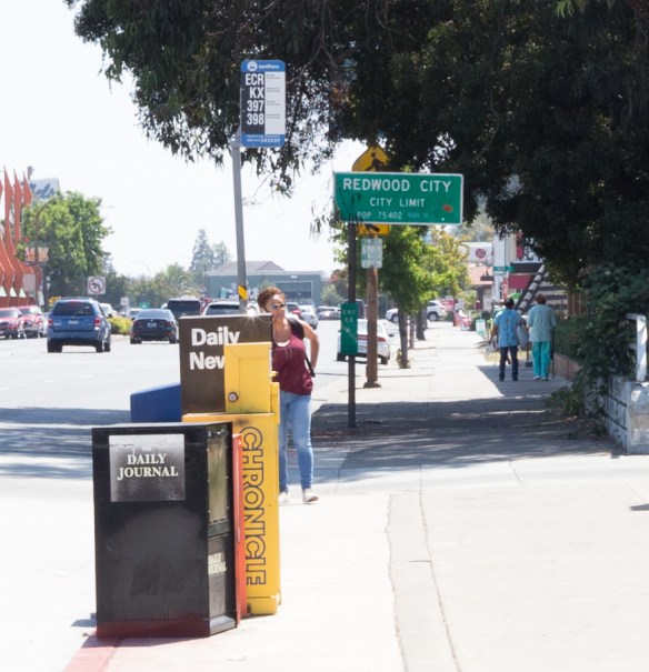
For those of you who read my post about fences (Good Fences Make Good Neighbors), you know that I am interested in the divisions between properties, and whether or not they are defined with a fence. I am even more intrigued by city borders. Unlike the division between two properties, rarely is it clear when you cross a city border. Of the hundreds (I’m guessing; I didn’t count) of streets that traverse Redwood City’s borders, only a very few give any indication of the crossing. El Camino Real is one of those that do. For instance, coming south from San Carlos there is a green City Limit sign above Cordilleras Creek, marking the division between Redwood City and San Carlos in this part of town:
More often, however, you just have to know that the border is there. Indeed, in some cases the border runs right down a street, such that one side falls within the city limits while the other does not.
Those of us who live in Redwood City have a vague idea of where the borders are, but if you think you know, I can pretty much guarantee that you are wrong. While one might think that our borders are roughly the Bay on the east side, Interstate 280 on the west side, Eaton Avenue on the north side, and perhaps Woodside Road on the south side, in fact Redwood City’s borders are quite a bit more bizarre than that. Here’s a map showing our city’s borders (in red), courtesy of maptechnica.com:
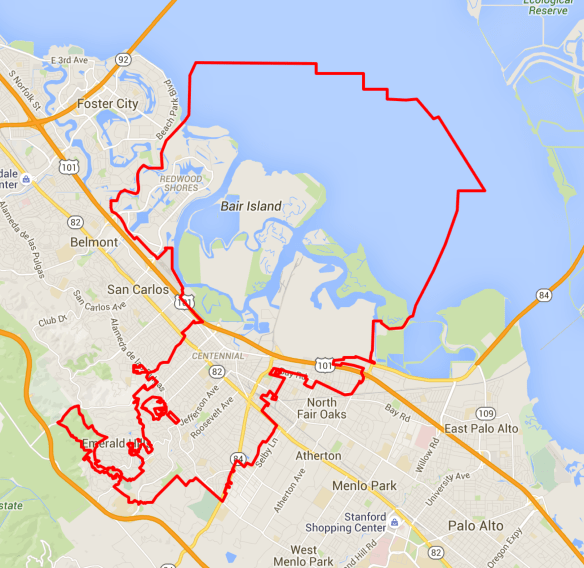
(Click the above image to enlarge it.)
As you can see, Redwood City’s official boundaries zig-zag all over the place. The border heads along 101 to the northwest in order to pick up Redwood Shores (which indeed lies within the city limits) but as you can see it skirts the San Carlos airport on the northeast side, putting the airport within San Carlos’s city limits. In the southwest corner the border runs right through Edgewood Park, such that a portion–but only a portion!–of the park lies within the city limits. The city border runs up to the area around Canãda College, but most of the college (including all of the academic buildings) lies outside of the city limits. Only the “Canãda Vista” apartment complex, built on the Canãda College campus for faculty and staff of the San Mateo Community College District, and one of the college’s parking lots lie within the city’s boundaries.
Although most of the land in the vicinity of Emerald Lake is unincorporated (as “Emerald Lake Hills,” or simply “Emerald Hills”), the city’s borders extend through it like a pseudopod to embrace both the Emerald Hills Golf Course and the Easter Bowl. Other areas where I find the border to be particularly interesting is where it jogs over to pick up the Redwood High School campus, and where it zig-zags in the vicinity of Marsh Road and Highway 101 so that the Porsche dealer and part of Bayfront Park fall within the city limits, while the nearby FedEx Shipping Center does not.
And then there are the strange goings-on near the intersection of Alameda de las Pulgas and Jefferson Avenue. Here’s a closer view of that area, with the interesting bits shaded in orange:
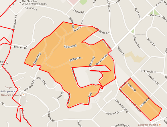
Those shaded areas are not actually within the city limits; they are bits of what is sometimes referred to as “unincorporated Redwood City.”
Unincorporated land is land that is not controlled by a local governing body (in this case, Redwood City) but is instead controlled by a higher-level entity (in this case, San Mateo County). An incorporated city or town such as Redwood City can:
- make its own laws for its citizens
- designate how land can be used (agricultural, residential, commercial, open space, etc.)
- create services such as fire and police departments
- impose taxes upon its residents to pay for services
- apply for funds from the state or federal government
Unincorporated areas can’t do any these. In the case of residents living in unincorporated areas around Redwood City, they are governed directly by the San Mateo County Board of Supervisors.
These little unincorporated “holes” that lie entirely within Redwood City’s borders fascinate me. A city grows in area by annexing land into itself, and I can only presume that as Redwood City grew, people living within these areas declined to become part of the city proper. Thus they end up in a sort of “twilight zone,” being entirely surrounded by Redwood City but not being a part of it.
While these mysterious gaps within the city borders draw my interest, so do the larger unincorporated areas that abut our city. These named areas, while controlled by the county, often have a residential association that can liaise with the county and pass on resident concerns. For instance, Emerald Lake Hills (also known as Emerald Hills) has its Emerald Hills Homeowner’s Association. To our north, Palomar Park has the Palomar Property Owners. And North Fair Oaks has its North Fair Oaks Community Council.
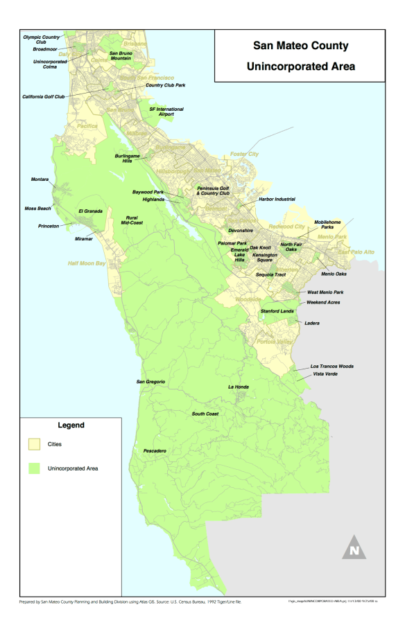
In researching the concept of unincorporated land, I was surprised to learn just how many unincorporated areas there are within San Mateo County. I was equally surprised to discover that the majority of the county is unincorporated. Here is a 1992 map of the county showing the unincorporated areas in green:
Because unincorporated areas rely upon the county for their services, when you call for help you might be surprised at who shows up. Law enforcement is generally provided by the Sheriff’s office, although in Palomar Park, at least, traffic issues apparently are dealt with by the California Highway Patrol. Fire services are more complicated. Generally, they are provided by the San Mateo County Department of Fire Protection (who contracts with the California Department of Forestry for its personnel). But in some cases the county has contracted with Redwood City for fire services; thus, if you report a fire in Emerald Hills the Redwood City Fire Department shows up. And in North Fair Oaks, it appears that you’ll be greeted by a representative of the Menlo Park Fire Protection District.
In certain areas Redwood City’s borders seem to have been drawn to ensure that vital services and those that will generate significant taxes fall within the city limits. In my neck of the woods, Sequoia Hospital (at Alameda de las Pulgas and Whipple Avenue) is just within the city limits, as is the strip center that once was home to Emerald Market (and still contains Sancho’s Taqueria, Emerald Hills Cafe and Roastery [formerly Canyon Coffee], and Speederia Pizza, among others). Canyon Inn is also within the city, although for some reason the little gas station (“Canyon Gas & Propane”) across the street is not.
On the subject of Emerald Market, I’ve been keeping a close eye on it. Although it appears from the outside that nothing is happening, work is indeed continuing on the two small restaurant spaces that have been carved out of the former market. I recently took this picture of one of the soon-to-be restaurants:
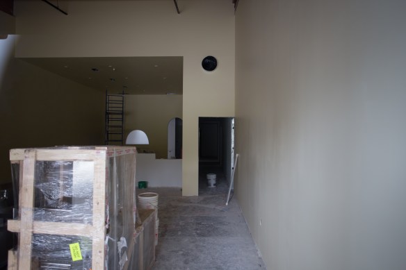
As you can see, although the floors have yet to be done the walls seem to have received their final finishes, and some of the restaurant equipment (still crated, in the above photo) is about to be installed.
The above picture was of the middle space, which sits between the now-smaller market on the left and the second restaurant space on the right. That second space is making similar progress:
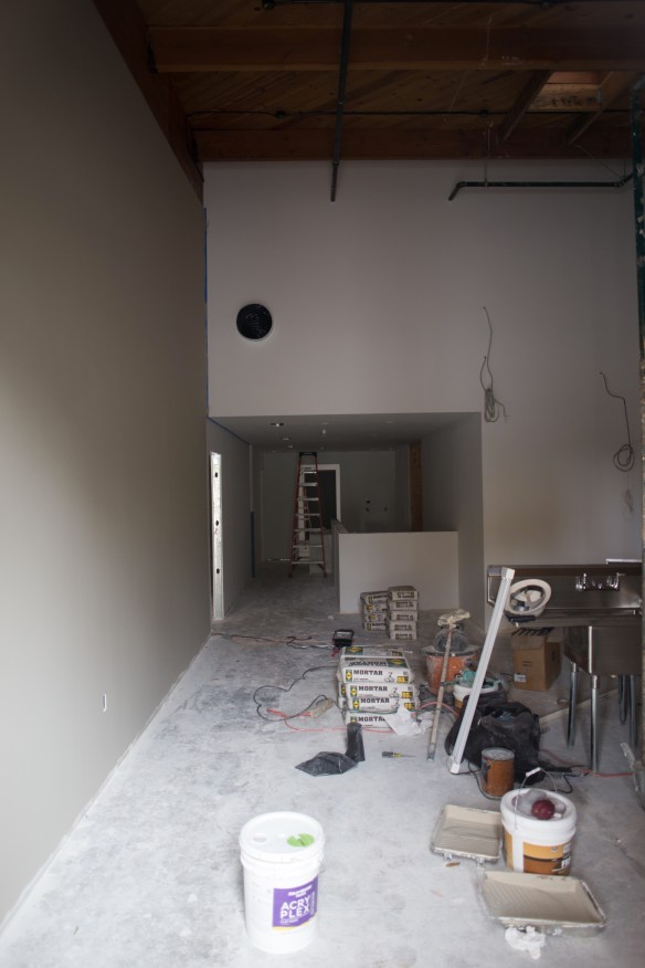
Note the sink, which I believe is waiting to be moved to its final destination, presumably near the back of the restaurant.
In looking over the center’s permits, I note that on November 23 they applied for a permit for fire suppression equipment to be installed in the hood over a kitchen stove. And the following day they applied for a new 4-inch Fire Service Connection. Given that these applications were filed just a couple of days before Thanksgiving, the remodel is definitely making progress, albeit slowly. Soon we may well see both “Hilltop” and “Kaigan Sushi,” the restaurants that early on were slated to go into these spots.
As for the market itself, I’m not seeing much activity in there. There is still a prominent “For Lease” sign on that part of the building; the plan is to put a smaller market into the now 3,000 square-foot space (Emerald Market was 7,600 square feet), but I’m guessing that the property owner has yet to sign a tenant. Hopefully a convenience market (a 7-11, maybe?) will agree to go in there; I’m sure that the neighborhood would love it.
Tracing Redwood City’s border is an interesting exercise. While I can’t honestly say that I have explored every bit of it yet, I plan to! Who knows what mysteries I will find in some of Redwood City’s obscure nooks and crannies? What lies within the unincorporated “twilight zones” that lie within and around Redwood City? Whatever I find, you can bet that you’ll be able to read about it here. So stay tuned! I should be a very interesting year.

Thank you for the very perceptive comments about RC’s tactical boundary-drawing. I happen to live in a different strip of unincorporated San Mateo County, south of you, West Menlo Park — though in our case it was because West Menlo residents including my parents successfully resisted annexation when City of Menlo Park expanded westwards to grab the Sharon Estate (now called “Sharon Heights”).
A few years ago, a portion of West Menlo (unwisely, in my view, considering Menlo Park’s recurring dysfunction), specifically the triangle formed by Santa Cruz Ave., Avy Ave., and Alameda de Las Pulgas, nonetheless applied to Menlo Park to get annexed. Revealingly, Menlo Park has dragged its feet on that application, staff and City Council members having expressed unhappiness with the idea of having to pay for street maintenance such as on much-neglected Sharon Ave., instead of palming off that duy on the county.
Pingback: Ask And Ye Shall Receive | Walking Redwood City
Greg, love this entry!This update on the Emerald Market building in this neighborhood was helpful.
You’re welcome. Thanks for reading!
Rumor has it that the Chase Bank parcel at 2300 Broadway has gone on the market and the city may buy it … and that it may be combined with the law library parcel to be redeveloped as a single full-block parcel. The DTPP heights for that block range from 3 stories on the Courthouse Square side to 12 stories on the Winslow side. Stay tuned…
https://www.facebook.com/groups/709200909129615/permalink/909996929050011/?comment_id=910103695706001
Interesting. Thanks for the tip. I’ve been keeping an eye on the Law Library (it may not be long for this world, sadly) but I’ll now be keeping an eye on the Chase Bank, too.
Greg,
I also enjoy your blog a great deal. I was wondering whether you might enjoy a tag-along companion on a walk in the future. I enjoy your point of view, and I would find it interesting to join you for a walk. I don’t know whether you are open to rambling with a stranger. If so, perhaps we can email off line. — Chris
So… Any idea what happened here? Broadway and Winslow in downtown.
>
I assume you are referring to the Broadway Masala spot? They had a fire late in the evening on December 22; they, plus the spot next door (that they are in the middle of expanding into) and the mobile payments company upstairs (Flint Mobile) have all been shut down and will remain so until repairs can be effected. Which I expect will take quite a while, unfortunately. Thanks for reminding me about this one: I saw the article about the fire, but it came across my screen just before Christmas; I’d forgotten about it. I visited it today and plan to write about it in this weeks’ post.
I enjoy your blog immensely & recommend it to my friends who are both long-time RWC residents & the new generation moving in. Thank you for doing this!
My pleasure! Thanks for reading.
Hey great reading as usual, thanks. I have always wondered at the City Taxes used at the North Fair Oaks Center that seem to me to support a lot of unincorporated non city residents. Shouldn’t the County supply these funds for those needs ?
I definitely need to understand the tax situation better. Certainly there are school taxes and such that I presume everyone pays since we all have (theoretically) kids that attend Redwood City schools. Perhaps the same applies to taxes that fund our parks and community centers? I have zero info on that, but perhaps someone who lives in one of the unincorporated areas can enlighten us.
I enjoy your blogs and have learned so much about RWC tho we’ve lived here a half century. Your comment about the strange city limits and the map brought a big smile. You wrote: “Here’s a closer view (map) of that area, with the interesting bits shaded in orange:”
You may add to the particularities that in the western corner 7 houses in the red area noted as county are actually in the city and have metal markers at the property lines that mark the city/county line. During emergency situations both city and county seem to respond maybe to be sure the proper entity will be on site.
Weird
Wow! That is indeed very strange. Heaven know what happened there…
The redlining on the map you show is not quite accurate. With the exception of a couple of houses on Hillcrest Dive near Upland, we are all county. However, the fenced in area at the end of Brewster (Brewster Reservoir) is owned by the city of Redwood City. It gets even more complicated when you start looking into water and sewer services especially if you build a home.
That the maps aren’t entirely accurate doesn’t surprise me, since the one I used isn’t maintained by the city. The city does have their own map that I probably should have used; I’ll need to compare the city’s with the one I used for the blog post. But I figure that the one I used is close enough to get the point across… 😎 I’ve compared notes with one or two people who live in Emerald Hills, and as far as remodeling goes, at least, I’m glad that I live within the city limits…
The county is a real PITA to deal with for permits/remodeling. It’s also very expensive to pull a permit as the building/planning department is self funded. I live on a county parcel with a redwood city address but on a fully incorporated street of an entirely different town. Made for an interesting permit process when we recently had to replace our sewer lateral…we ended up having to get a permit from both jurisdictions!
Love reading your blog. please keep it up!
I sure plan to. Thanks!
Incidentally, I’m always looking for new readers, so feel free to share with your friends!
Happy New Year Greg! Always look forward to reading your blog every Friday.
Thank you for reading!
Thank you for the description of the unincorporated “holes” in RWC. When you get a chance, can you take a look at what’s been going on at Red Morton? The tennis courts are gone and the soccer fields are all torn up.
Keep up the great work!
I’ll walk over there this week (assuming it doesn’t rain too much!) but this should answer your question: http://www.redwoodcity.org/Home/Components/News/News/460/874
I have found good info here too – straight from the icty. https://medium.com/redwood-city-voice
Absolutely – the city has really upped their game regarding communications. Meghan Horrigan (the city’s “Public Communication Manager”) and her team have really embraced a number of avenues of electronic communication such as Medium (which hosts Redwood City Voice) and NextDoor. I’ve recommended that people subscribe to Redwood City Voice in the past; perhaps it is time to do so again. Of course, I’m slightly biased as I was honored to write the second-ever article on Redwood City Voice (the first was written by the Mayor) back in June of 2015. 😎