
I often walk down El Camino to investigate goings-on near our southern border. The conversion of the old Chevy’s restaurant into the current Planned Parenthood clinic, the demolition of Mel’s Bowl and subsequent construction of “The Lane on the Boulevard,” and the construction of the University Art store have all kept me heading that way in the past. And now, with the onset of construction on the 45-unit assisted living facility being built where Jackson Square Fine Jewelers once stood (at 2808 El Camino), I plan to continue making forays south of Woodside Road.
It wasn’t until I had made several trips back and forth that it occurred to me to wonder about the name of this particular enterprise:
Initially I presumed that the name had something to do with the number of bolts used to secure a wheel to a car axle (most seem to use five). But actual research—as opposed to mere speculation—taught me that my assumption was incorrect. Five Points actually refers to (or, perhaps more accurately, once referred to) the area in the vicinity of the El Camino and Woodside Road intersection. Nowadays it seems that the appellation is no longer used, perhaps because there is no longer much need to refer to that part of town by a specific name. Once upon a time, however, the name “Five Points” was well-known in and around Redwood City.
Although you’d be hard pressed to figure this out given the current configuration, the name Five Points actually arises from the five streets that once converged at this intersection. The five streets, or “points”, were: Woodside Road, El Camino Real, Redwood Avenue, Spruce Street, and Main (or Mound) Street. Before the mid 1960’s, when the Woodside Road overpass was constructed, Woodside Road came in from the southwest and terminated at El Camino. Only after the overpass was built was Woodside extended to Highway 101. Back then El Camino extended in both directions as it does today. Main Street (which, as I mentioned in my post Walking Back in Time was originally named Mound Street), came in at an angle and terminated at the intersection, also as it does today. Redwood Avenue was as it is now, intersecting El Camino at right angles, although it appears to have been a more significant street. And then there is Spruce Street. Spruce Street today is a mere shadow of its former self: a small loop that starts and ends on Main Street, encircling a dry cleaner and the La Azteca Mexican restaurant and market. But before the interchange, Spruce was a good-sized street that extended from Five Points towards the bay, essentially following the line that Woodside Road now takes.
Thanks to the miracle of Google Earth and its ability to look back in time, we can get a glimpse of what this intersection looked like back in the 1940’s:
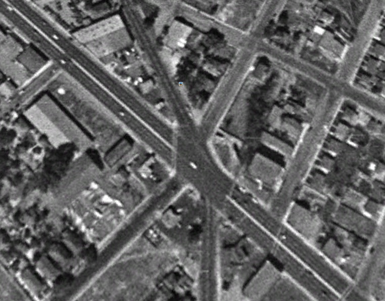
In this image, El Camino is clearly visible as the two-lane road extending from the upper left to the lower right. Main Street is at the 11 o’clock position, Spruce Street is at 1 o’clock, Woodside Road is that small street occupying the 6 o’clock position, and Redwood Avenue extends towards 8 o’clock.
Compare the old configuration with how it looks today:
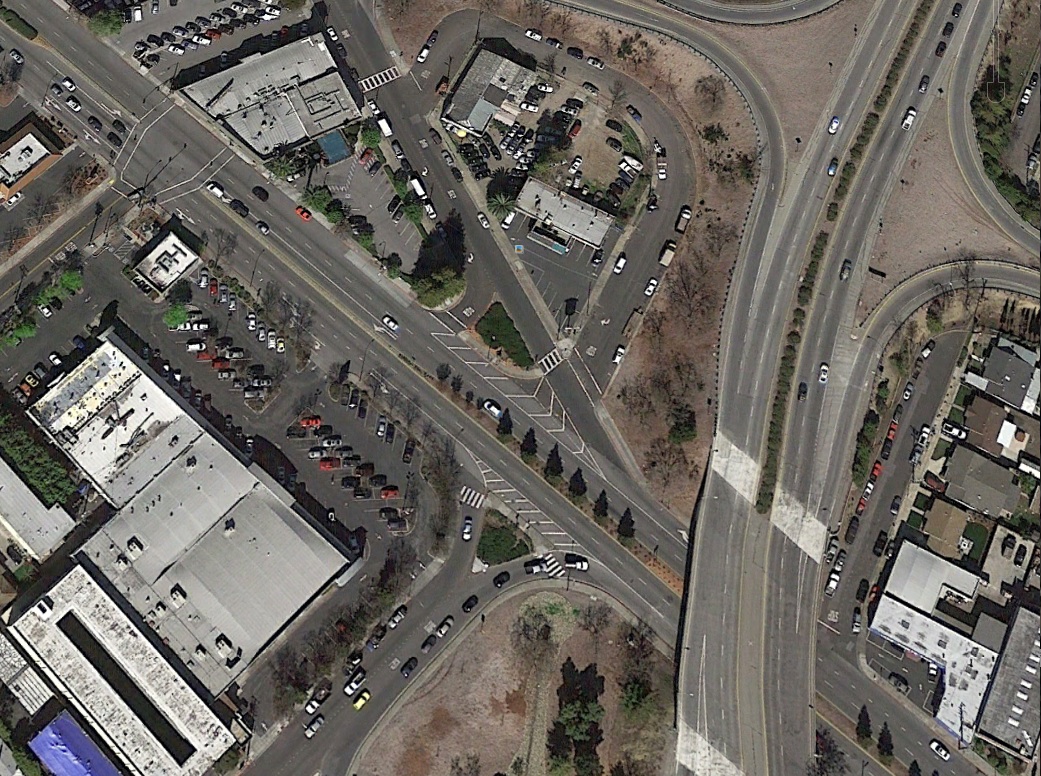
El Camino has clearly grown, but overshadowing everything is Woodside Road. It makes Redwood, Spruce, and Main look positively puny by comparison. At least the modern configuration does a pretty good job of handling the traffic that daily travels through this very busy intersection. Can you imagine the mess we would have if Five Points retained its original configuration? Back in the 1940’s traffic may have been more manageable, but I can only imagine being a driver and approaching Five Points. Your head would have had to have been mounted on a swivel to check for traffic converging on your spot.
Although the name “Five Points” may have been logical, and the traffic here may have been difficult, that isn’t why the name was so well known. At one time the area was infamous: so much so that young ladies, particularly when unescorted, were warned in no uncertain terms to avoid the area at all costs.
Back in the days of prohibition El Camino was part of the route that rum runners used to transport their product from Moss Landing or Alviso—where the illegal booze was brought to our shores—and San Francisco. At the same time, Woodside Road was a major route for the loggers working the Woodside-area lumber camps as they emerged from the hills looking for a good time. The confluence of these roads at the Five Points intersection, which stood about a mile outside of downtown Redwood City, made it a natural spot for saloons and boardinghouses of a less than savory nature.
Prohibition seems to have been a major influence on Five Points. Before the passage of the Eighteenth Amendment there were several reputable businesses in the area, such as Victor Bernasque’s French restaurant and boarding house. But the onset of prohibition, which would prevent Victor Bernasque from serving wine with his food, caused him to sell to a couple of men from San Francisco. The new owners renamed the place the “Fly Trap Inn,” giving patrons some idea of the new nature of the establishment. Needless to say, although they did a healthy business all through prohibition, the new owners had regular run-ins with both the local law and the federal revenue officers who were attempting to enforce the provisions of the Eighteenth Amendment.
Indeed, between January 1919, when the Eighteenth Amendment establishing prohibition was ratified, and January 1920, when it took effect, several businesses in the Five Points area changed hands. As well, the demand for alcohol both in the area and up north in San Francisco meant that an increasing number of heavily loaded trucks transporting illegal booze were found speeding through the Five Points intersection. This illicit traffic, added to the concentration of unsavory businesses in such a small area, caused Five Points to develop its less than respectable reputation.
As an illustration of the rather boisterous nature of the area, the Five Points Hotel at 2015 El Camino Real frequently found itself calling on the local ambulance services. Calls to that location were invariably seen as dangerous. Ralph H Ratliff, who owned Peninsula Ambulance Service, used to complain about employees being injured on calls to the hotel. Although some of the danger may have been exaggerated, the hotel was closed down in the early 1950s by the Redwood City Police.
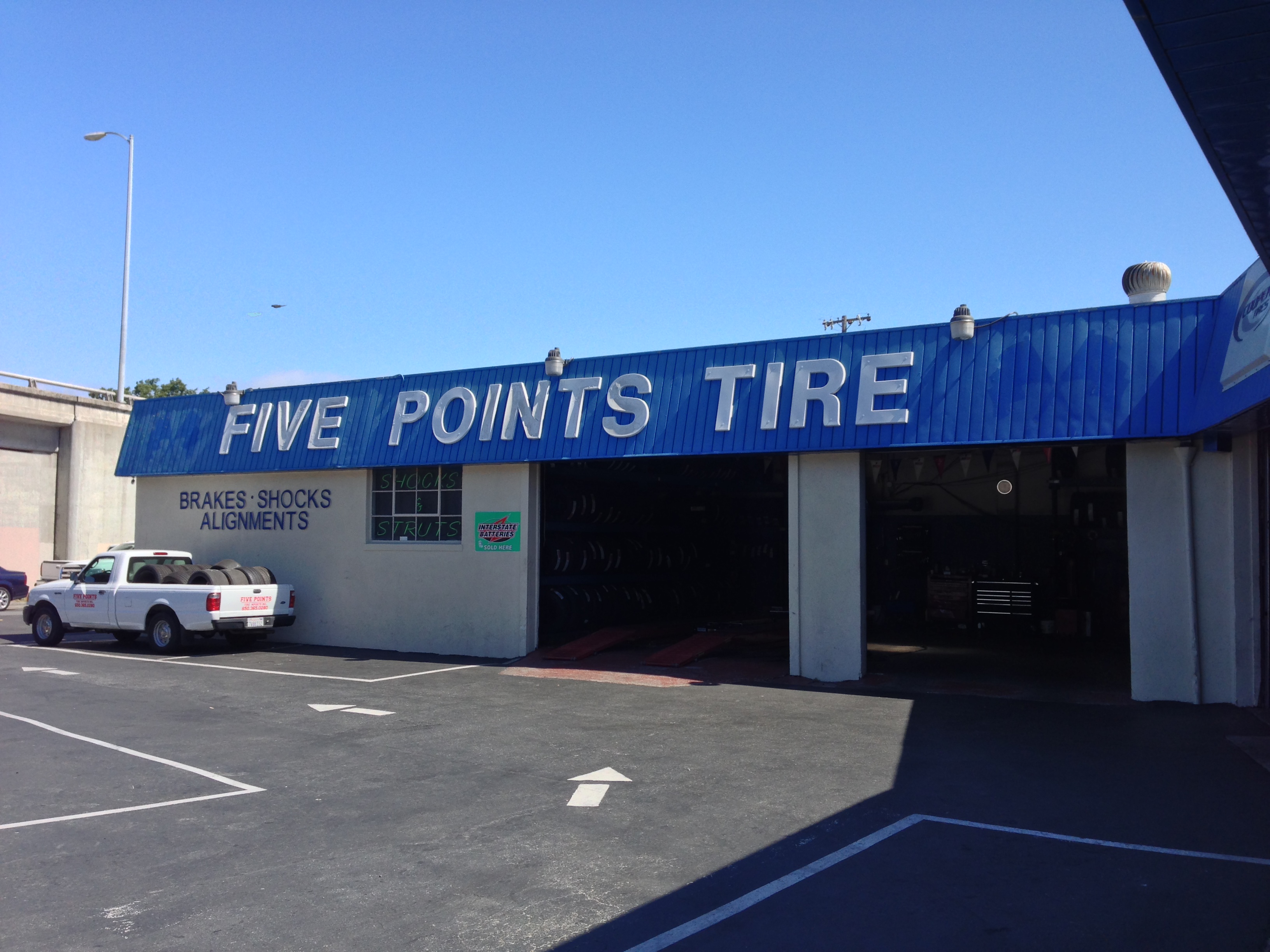
Prohibition may have started the downward slide in the area’s reputation, but the end of prohibition didn’t reverse that trend. Even after prohibition ended, the ease of access to the area provided by El Camino continued to fuel the shady businesses that were by then thriving in Five Points. It wasn’t until the late 1950’s that things started to turn, when the tanneries, boardinghouses, and saloons began being torn down and replaced with single-family homes, low-rise apartments, and more reputable businesses such as Redwood Surplus (now Redwood Trading Post)—which began in a Quonset hut on Main Street in Five Points. The final stake through the heart of the area’s unsavory reputation was the reconfiguration of the intersection in the mid 1960’s. Today, Five Points Tire is the only reminder of the area’s once notorious past.

One on corner of ‘5 Points’ there was a gas station. I want to call it a ‘Star & Bar’ but not sure. My Mom was happy when I’d get gas there, I think they offered ’10 times’ blue chips stamps. And I believe they gave out free things with a fillup (seemed so common back then). I still have a set of drinking glasses from there, they have different tourist attraction drawings on them of San Francisco.
My father, Con Dempsey, grew up in Redwood City, and I have just, and finally, moved back. He often would tell us things about the history of ‘The way things used to be,” a pictured fact with heartfelt words. I really miss my Dad, and can still feel enriched when I read an article like, Walking Redwood City,
quality bit of
Thanks for the comment, and welcome (back?) to Redwood City! I do so enjoy researching the historical pieces.
I am trying to figure out the address of the Paulsen Property at the gore of Woodside and El Camino. Paul Paulsen was a long time resident and Pioneer of Redwood City. The house was demolished during his lifetime which ended in 1923. There it states that he passed away near his home on Manzanita. This all points to the southern block where the 84 on-ramp is now. Would you happen to know more about this area?
I would suggest going into the Local History Room in the main branch of the public library: they have tons of old phone directories and maps and such that will have what you are looking for. Having said that, I’m not sure that the Local History Room is back open again, given that the library is operating with limited service and limited hours. But if and when it opens, that’s where you’ll easily find what you need (and the folks there are very helpful, I should note).
Hi there – I actually found “Unrecorded Maps” of Redwood City and I was able to see Paul Paulsen’s property right at the corner of El Camino and Woodside in a triangular fashion! Thank you for your help!
Excellent! Glad you found what you are looking for.
I don’t know why, after all this time, the name “Five Points” came to mine, so I googled and that brought me to your blog. I was born in Redwood City when there was five points there. I was not much more than a baby, but one of my earliest memories is being seated in the car while my mother was waiting at what would have been Woodside Road, either attempting to cross or turn onto El Camino. Ordinarily traffic was not so bad, but it was bad there. “Five Points” was famous then. A conversation would go. “Hey, what took you so long?” And then, “I had to cross Five Points.”
Roy, you might enjoy reading some more on “Five Points” . Facebook – Redwood City Memories.