
On Monday the Redwood City Council approved, as part of its “consent calendar” (a set of ostensibly routine items that are generally approved with a single vote, usually with no discussion) a Resolution of Intention to establish a pedestrian mall on the 2000 block of Broadway and on Redwood Creek between the Main Street Parking Lot and Marshall Street Garage and authorize staff to record the Resolution of Intention and to provide notice. That particular second of Broadway (and of the short cross-streets leading to the parking lot and parking garage) has of course been closed to traffic since early in the pandemic, and many of us have been dining outdoors in that closed-off area for years now. But because the vast majority of the businesses in that specific area are restaurants, and because nearly all of those have benefited from the outdoor seating, there is a great deal of support to keep those portions of street closed permanently.
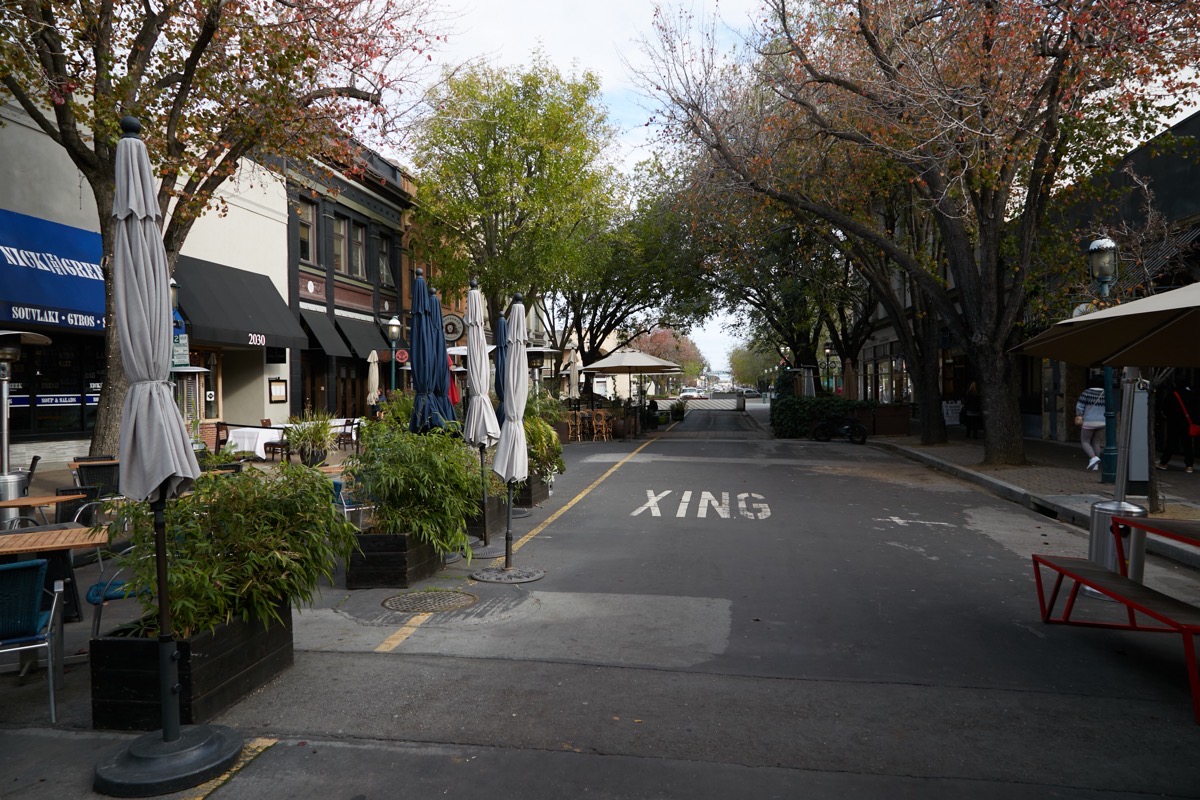
That support is not unanimous — there are at least one or two retail businesses that are less than thrilled — but it’s pretty overwhelming. There are still issues to be worked out, primarily around making deliveries and performing trash pickups. But Monday’s action is the next step towards actually closing off those street sections and reworking them to make it feel much less like one is eating a meal in the middle of a street. Note that, contrary to what you may have heard, the city has not yet actually decided to make the street closure permanent. Instead, as the lengthy resolution states, it merely signaled its intention to turn the 2000 block of Broadway (the section between Jefferson Avenue and Main Street), and the short cross-street that stretches from the Marshall Street garage to the Main Street parking lot, into a pedestrian mall. As for when the City Council will actually decide (or not) to make the closure official, that apparently will happen during a public hearing at their April 15 meeting. That is the deadline by which anyone feeling that they would have a legal claim to damages resulting from such a closure must file their claim with the City Clerk, and that is when the City Council will actually hear protests, objections, or voices in support of the closure.
Assuming that the council does indeed decide to make the closure permanent on that (or a later) date, don’t expect a magical transformation of the area anytime soon. Because any improvements would be paid for out of the city’s general fund, and because the city is currently experiencing a budget shortfall, it may be years before the temporary measures that are in place today are replaced with more permanent, and more attractive ones. But along with the resolution of intent came a basic recommended design, so we can dream.
First off, the Jefferson Avenue end:
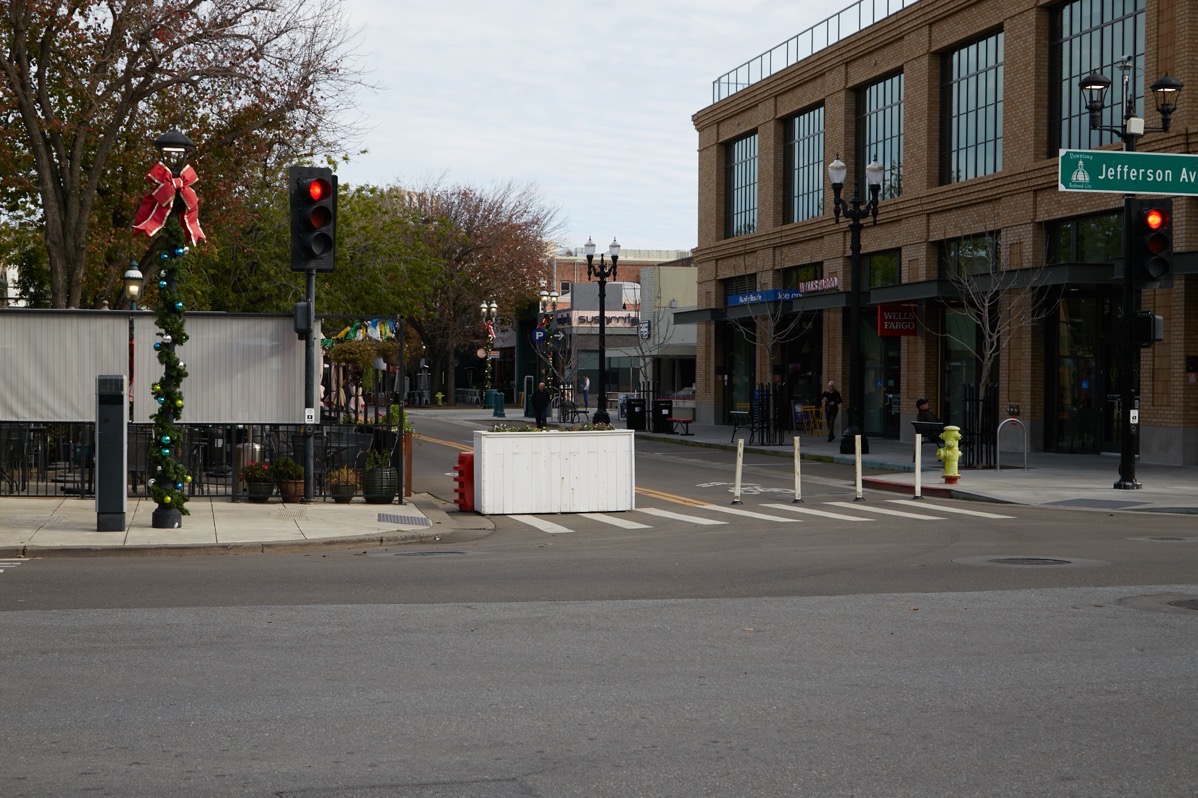
The white planter (plus the orange water-filled barrier behind it) and the temporary plastic posts that block this end of the pedestrian mall would be replaced by a set of pneumatic bollards (metal posts that would sink into the street when access by emergency vehicles is needed). In the closed-off section the street would be reconfigured with a single vehicular access lane down the center of the roadway, leaving most of today’s two traffic lanes available for restaurant seating.
At this end of the closure, the rough plan indicates that signage would be added, telling cyclists and those riding scooters to get off and either park or walk their vehicles through the closed area.
The Main Street end of Broadway would get similar treatment: pneumatic bollards and a sign about parking or walking bikes and scooters. Those bollards would certainly look more attractive than what is there today:
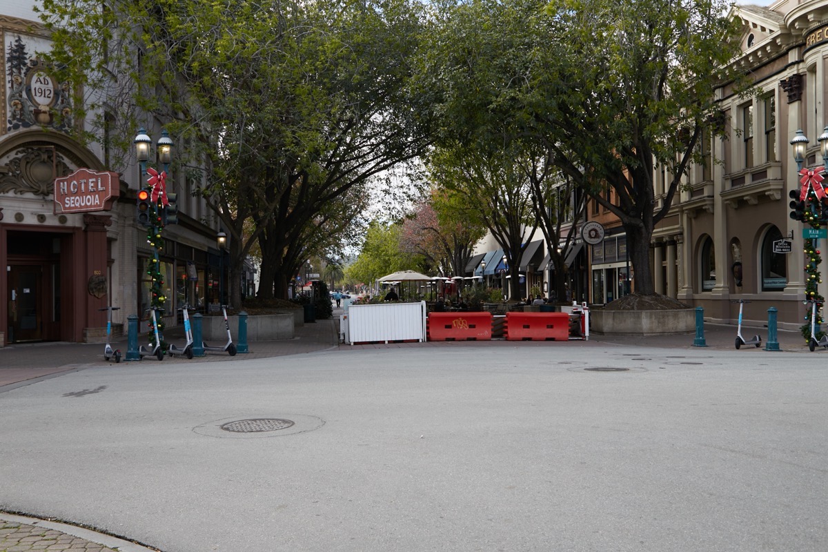
Oddly, the planter and plastic barriers you see in the above photo sit directly in front of a large mechanical barrier that the city apparently owns and put in place when this section of Broadway was first closed:

Given that this mechanical barrier is designed to be opened to let emergency vehicles in and out (the large metal plate with the yellow striping folds down flat), it seems a bit odd that additional barriers were placed in front of it, making any access here essentially impossible. In any case, all of this would go away, replaced by some reasonably attractive metal posts.
Because the cross street led into and out of the Marshall Street parking garage (which of course also has an entrance and exit on Marshall Street), when the temporary closure was put in place the city simply threw some construction fencing across the garage’s Broadway entrance/exit:
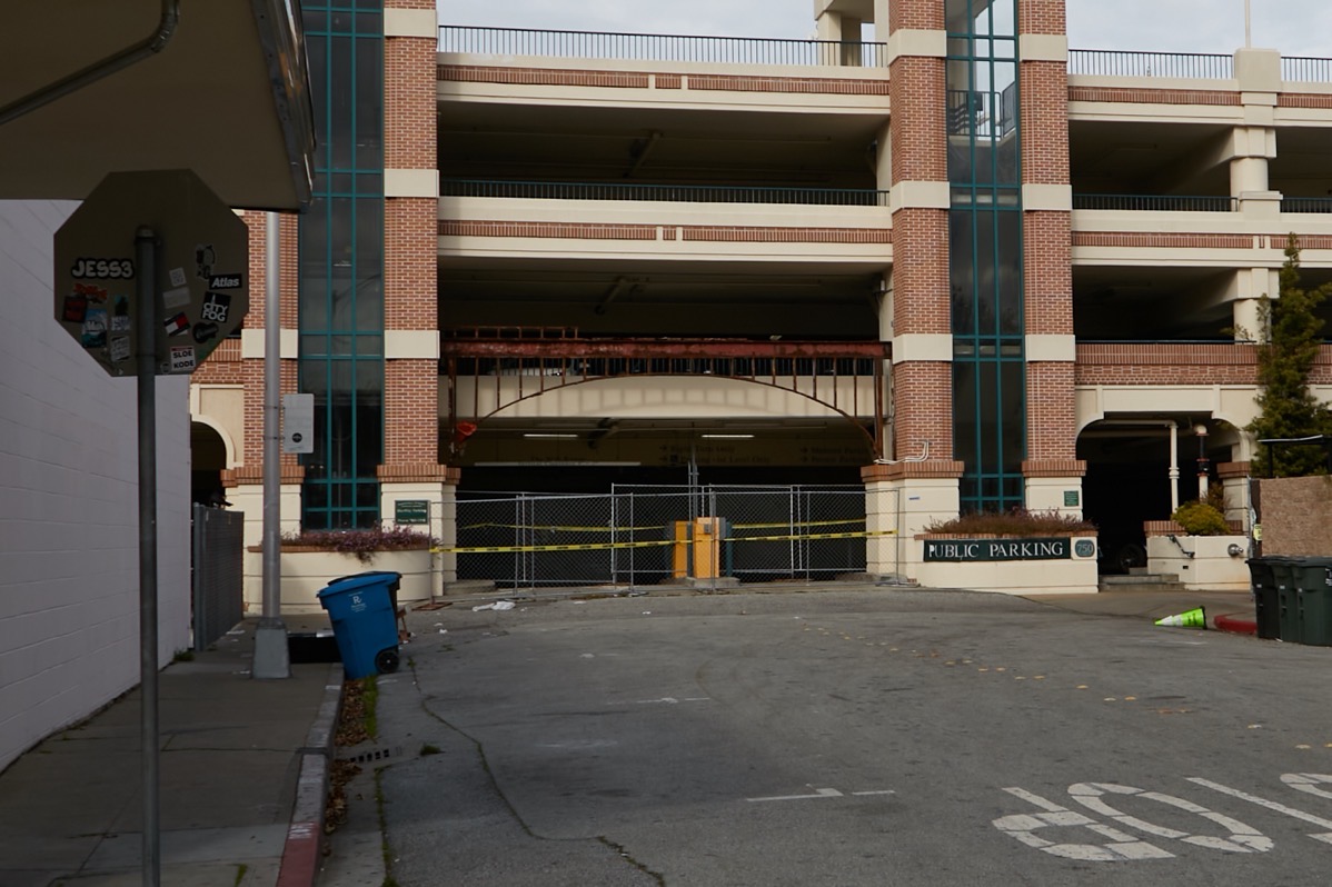
That makes for a functional solution, but not a very attractive one. The plan does not specify what, if anything, would be done here, beyond stating that the open “plaza” that is the street you see above would be adorned with art of some sort. Presumably the exposed metal arch above the garage entrance, which used to hold a sign identifying the Marshall Street Parking Garage, would at least again be covered, likely with a sign again identifying the garage.
Finally, the opposite end of this short street, which provided access to and from the Main Street parking lot from Broadway, has had temporary plastic “bollards” in place for some time now. These plastic bollards are designed so that a vehicle can simply run over them, enabling garbage trucks and delivery trucks to access the otherwise closed-off area. Unfortunately, if you run over them enough, they no longer spring back to their vertical position:

As you can see, the city seems to have put a portable orange pylon to perhaps stand in for the non-functioning bollards, but someone apparently decided that getting out of their vehicle and temporarily moving the orange pylon aside was too much work. Long-term, the plan calls for a swing-arm gate, activated by a key card, at this point. But clearly a better short-term solution than what we have today will have to be put in place. Although delivery vehicles can park in the Marshall Street garage or the Main Street parking lot and bring in their goods using a dolly, many of the businesses on the north side of Broadway have trash enclosures with dumpsters in the small alley that runs between those businesses and the Marshall Street Parking Garage:
Clearly the garbage trucks still need to get to this point, and the only way they can do that is from the Main Street parking lot (over those flattened plastic bollards, at the moment). Thus the need for a motorized gate or some such at the entrance to the closed-off area from the Main Street lot.
Emergency vehicles (and, presumably, construction vehicles whenever they need access to the fronts of the buildings along the pedestrian mall) will also still need access to Broadway, but not as frequently. They would likely enter the area from the ends of the closed street by triggering the pneumatic bollards to sink into the ground.
Although city funds are tight, and thus things like pneumatic bollards are likely far in our future, some cheaper, cosmetic changes would likely be made once the closure is made official. For one, the rather unsightly orange plastic barriers would probably be replaced by something more attractive (perhaps more white planters?). Too, the traffic signals at either end of the pedestrian mall would likely get reprogrammed: currently, they still operate as if cars are entering and exiting the closed section of Broadway. And clearly something will need to be done at the access point in the Main Street parking lot. Whether that simply means periodic replacement of the plastic bollards, or the actual installation of a swing-arm gate, or something else, well, we’ll simply have to see.
As one who has been advocating for the closure of a portion of Broadway in Redwood City for years now (I first wrote up my thoughts back in March of 2015, in my post A Modest Proposal), I’m pleased to see progress on this — although I find it a tad frustrating at how slowly the wheels of government turn. Assuming that the city does actually make the closure of the 2000 block official, I intend to continue lobbying for the closure of additional blocks. I still maintain that the closure should extend farther to the west, at least as far as Hamilton Street (that is, through the block containing Courthouse Square). After all, the block of Broadway between Jefferson Avenue and Middlefield Road is mostly restaurants, too. At one time, the center of that block was home to the Dragon Theatre, but that theater has been closed for some time now, and is now slated to be remodeled and transformed into yet another restaurant, this one serving Indian cuisine (apparently, a second location for the Brundavan restaurant currently located in Santa Clara). If that happens, essentially all of the north side of the street along that block will be restaurants. And because that section of Broadway remains open to traffic, those restaurants are extremely limited in the amount of outdoor seating they can provide:

For the record, the south side of the street is entirely filled by the Century Theatres building. Although Sola Salon takes up the central portion of that building along Broadway, the west end is home to Five Guys burgers, while the east end is slated to hold Ocean Oyster Bar and Grill. Thus, I think one could make a pretty solid case for closing this block of Broadway, too.
Changing the subject, this week I took a somewhat lengthy walk to check on the progress of San Mateo County’s Mental Health Center, which is located just west of the parking lot for the Pulgas Ridge Open Space Preserve, which itself is located across Edgewood Road from Edgewood Park. I got there by following Cordilleras Road west to where it meets Edgewood Road, then continuing west along Edgewood Road until I got to Crestview Drive. I then headed up Crestview for a very short distance, and turned left to follow Edmonds Road. The Mental Health Center is located at the very west end of Edmonds Road:
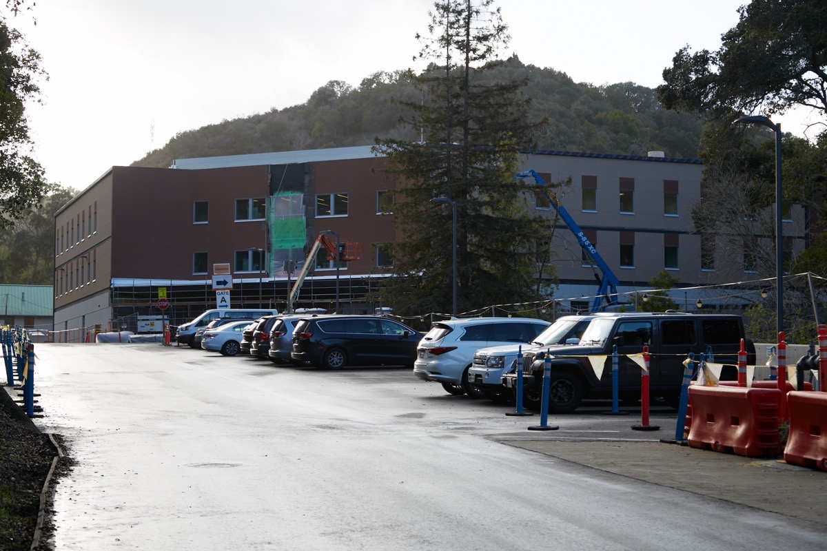
At long last this building — the largest of five buildings that will comprise the rebuilt center — appears to be nearing completion; the entire campus is slated to be done by the end of this year. The building you see above is referred to as the Campus Center, and will contain examination rooms, conference rooms, a commercial kitchen, a chapel, an art center, an exercise room, and more. The two upper floors of the center will be designated for supported housing: it will be capable of housing 57 residents, each in their own room. As for the rest of the center’s residents, they will be housed in four single-story K-shaped Mental Health Rehabilitation Centers (MHRCs), each of which can accommodate 16 patients. Together these five buildings will surround a central open space with sheltered outdoor seating, community gardens, and recreation areas:
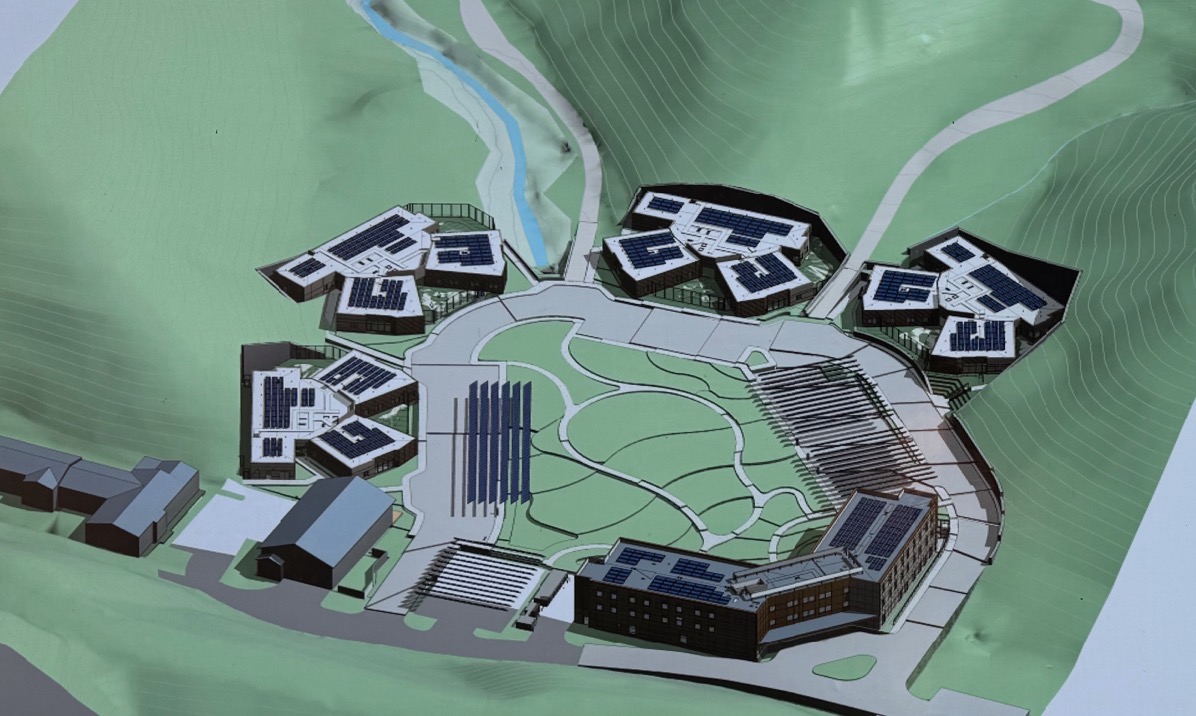
(The two somewhat conventionally-shaped buildings towards the left are not part of the mental health complex; they are a fire station and, extending off the edge of the image, the Canyon Oaks Youth Center.)
Because the project is under active construction, I’ve been hesitant to wander much farther than the front of the Campus Center, and it blocks the view towards the four other buildings (which apparently were constructed first). I did manage to make my way around to the right of the Campus Center, though, to get a glimpse of one:
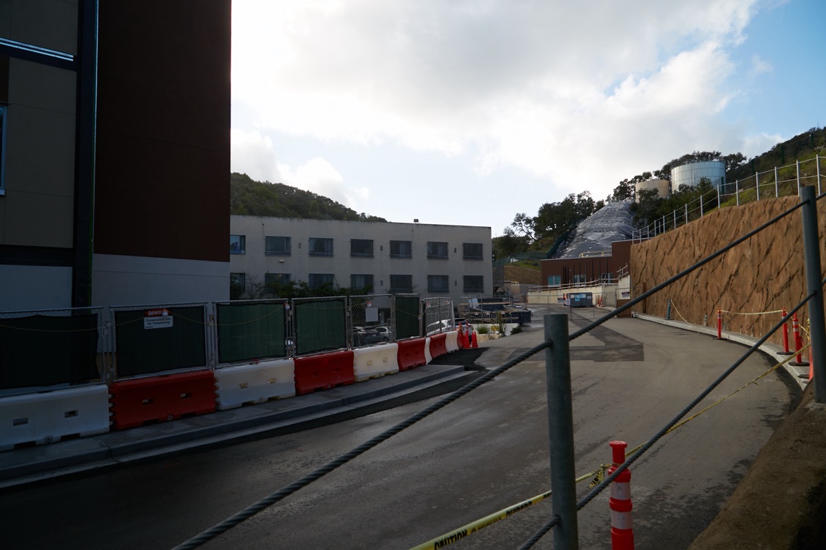
The blocky multi-story building in the center of the photograph is the old Mental Health Center, which consisted of a single Y-shaped building (here you can just see one arm of that Y). To the right of that you can just make out a dark brown building with a couple of windows: that apparently is the right-most of the four MHRCs you can see in the site plan.Once the new Campus Center building is complete and occupied, the old Mental Health Center will be torn down, and the central open space will be created.
This center is a County-owned psychiatric facility for adults with chronic, serious mental illness. The old facility — which was built in 1952 as a tuberculosis hospital and then adapted to its present use in 1978 — has become costly to maintain, and needs frequent repairs. Thus this new facility, which, while meeting modern standards of care, is also designed for net zero energy usage (solar panels will produce energy on-site).

Thanks so much for the clarification on what the city council’s pedestrian mall resolution did. Sad there’s still more process but so glad to see it moving along!
Thanks for your reports! I may have missed it from one of your walks, but I’m curious about the fenced off area that housed McDonalds until the fire on Woodside Road.
McDonald’s intends to build a new restaurant on that site. I assume they are in the planning/permit process; I should check on that…
I was looking at the McDonald’s property the other day. It is a huge lot. Will be interesting to see how big of building they build. I’m assuming they will incorporate the extra parking lot into the rest of the property.
New McDonald’s going in there.