
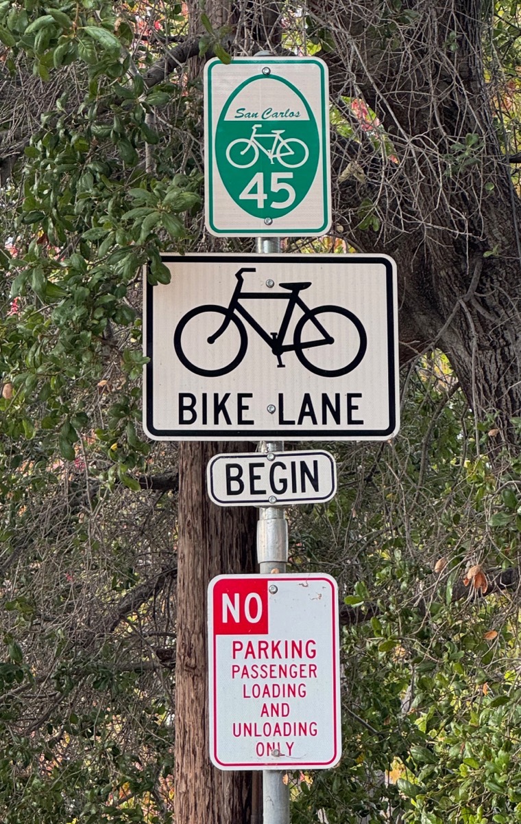
When reading this week’s blog post title, I’m guessing that at least half of you immediately think of a small vinyl record that plays at 45 rpm. Which is indeed where I got the idea for the title. However, rather than referring to something you’d play on a turntable, what I’m really writing about this week is this sign:

More accurately, the bike path of which this sign is a part. Yeah, yeah, the guy who walks all around Redwood City (and elsewhere) is writing (at least in part) this week about a bike path. One that I’ve been curious about for a while, and finally decided to follow.
I tried to do some research but came up empty-handed on the “45” part of the sign; I assume that it is a route number. But after spending a fair amount of time poking around on the internet (and in Redwood City’s online document archives) I have yet to find anything mentioning these signs or a bike route identified by the number 45. There are a number of designated bike routes through Redwood City, of course, and although these signs mark out a contiguous bike path that leads from San Carlos to North Fair Oaks (or more; it does go into San Carlos, but I didn’t follow it this week beyond Redwood City’s northern border to see how far it goes in that direction), none of the maps that I could find show this specific route. The maps do show multiple bike paths that together make up the route, but portions of the path are shown in different colors (and sometimes as a solid line, sometimes as a dotted line), indicating that multiple routes seem to share part of the path. None of the maps shine any light on exactly what the “45” actually means. I even sent an email to Jessica Manzi, a Senior Transportation Coordinator with Redwood City who is also an avid cyclist, but it turns out that as of September 15 she has moved on, and is no longer with Redwood City. So, if any of you reading this know the background on this route, please respond to this post and enlighten all of us.
As I noted, the path does go into San Carlos; north of the Redwood City border along Stafford Street (at Cordilleras Creek) there is this sign:
Note how the sign looks similar, but instead of a Redwood City emblem at the top the sign says “San Carlos.” That kind-of implies that the route runs the length of the county but, as I noted, I have yet to try to trace it beyond the limits of Redwood City.
Just about a block south of the above sign is the northernmost of the many signs along the route in Redwood City:

Heading south, from Cordilleras Creek the route follows Stafford Street until D Street. There it jogs east one block, to Arguello Street. It then turns south on Arguello, crossing Whipple and Brewster avenues. When it reaches Marshall Street, it continues straight ahead — but the street name there changes to Broadway. Route 45 continues on Broadway only until the next signal; there, at Winslow Street, it turns right. The route then follows Winslow past Theatre Way, and continues straight ahead (although the name of the street changes there, to Middlefield Road). It then follows Middlefield Road all the way to and beyond Woodside Road, down to Douglas Avenue, where Redwood City comes to an end and North Fair Oaks begins. There is a “45” route sign on Middlefield Road just north of Douglas Avenue (on the northbound side) but south of there, although maps show the route continuing, there don’t seem to be any more “45” signs. Then again, Middlefield Road is still being reconstructed along there; perhaps once that is complete, some will appear?
I may just need to dust off my bike once again (the last time I rode my bike for this blog was when I traced the Peninsula Bikeway, in late 2018 (see my post Clinging to Summer). Clearly I’m overdue…
This week I was delighted to see that the “permanent” barrier at the Winslow Street end of Theatre Way (aka Middlefield Road) is finally getting installed. Back in 2020 Redwood City set aside money for something more substantial than the orange plastic “Jersey barriers” that they’ve been using in the interim, and in July of 2021 the City Council finally approved the purchase of surface-mounted sliding bollards to make permanent the closure of that street to vehicles (except for deliveries, trash pickup, and emergency situations). At the time I wrote briefly about these bollards, which are fascinating. Here is what ours look like:

You may have seen something like these before, but often bollards like these act like pistons, dropping down into the ground to provide access. Here though, the Jefferson Avenue Parking Garage, which is located beneath the Century Theatres building, also extends beneath Theatre Way. Thus, if these dropped down, they’d emerge into the ceiling (or, perhaps, a wall) of the parking garage, which clearly isn’t going to work. Thus, the system you see here, in which the two center bollards slide to the sides when vehicular access is needed. Note the slots along which those two bollards slide:

In case there is any doubt, just two days earlier I took a photo of the slab on which this system sits (before the bollards had been installed):

Neat, huh? I hope to catch them in action someday. I’m also curious about how they are activated (there is a manually-operated version, but Redwood City appears to have purchased the “electro mechanical” system; see the product website for more, including a video). In the first photo, note the large gray metal box to the left of the palm tree; that contains the control circuitry for this system. In both the first and second photo, note the slender poles just beyond the two outermost bollards; these seem to hold optical sensors that prevent the bollards from closing if a vehicle is blocking the way, much as modern home garage door systems do. What I don’t see (yet, anyway) is a keypad or some such to activate the bollards. While a remote control (like a garage door opener) could theoretically be used, all emergency vehicles would have to be suitably equipped, and I just don’t see that happening. I’ll check back next week. If nothing like that has been added, I’ll take a closer look at the control cabinet; perhaps it has a keypad or a key switch on the side.
Leaving Theatre Way, but sticking with the subject of street barriers for a moment, I thought it interesting that a planter (that presumably will soon be filled with plants of some sort) is now serving as part of the temporary street barrier on Broadway at Jefferson Avenue:
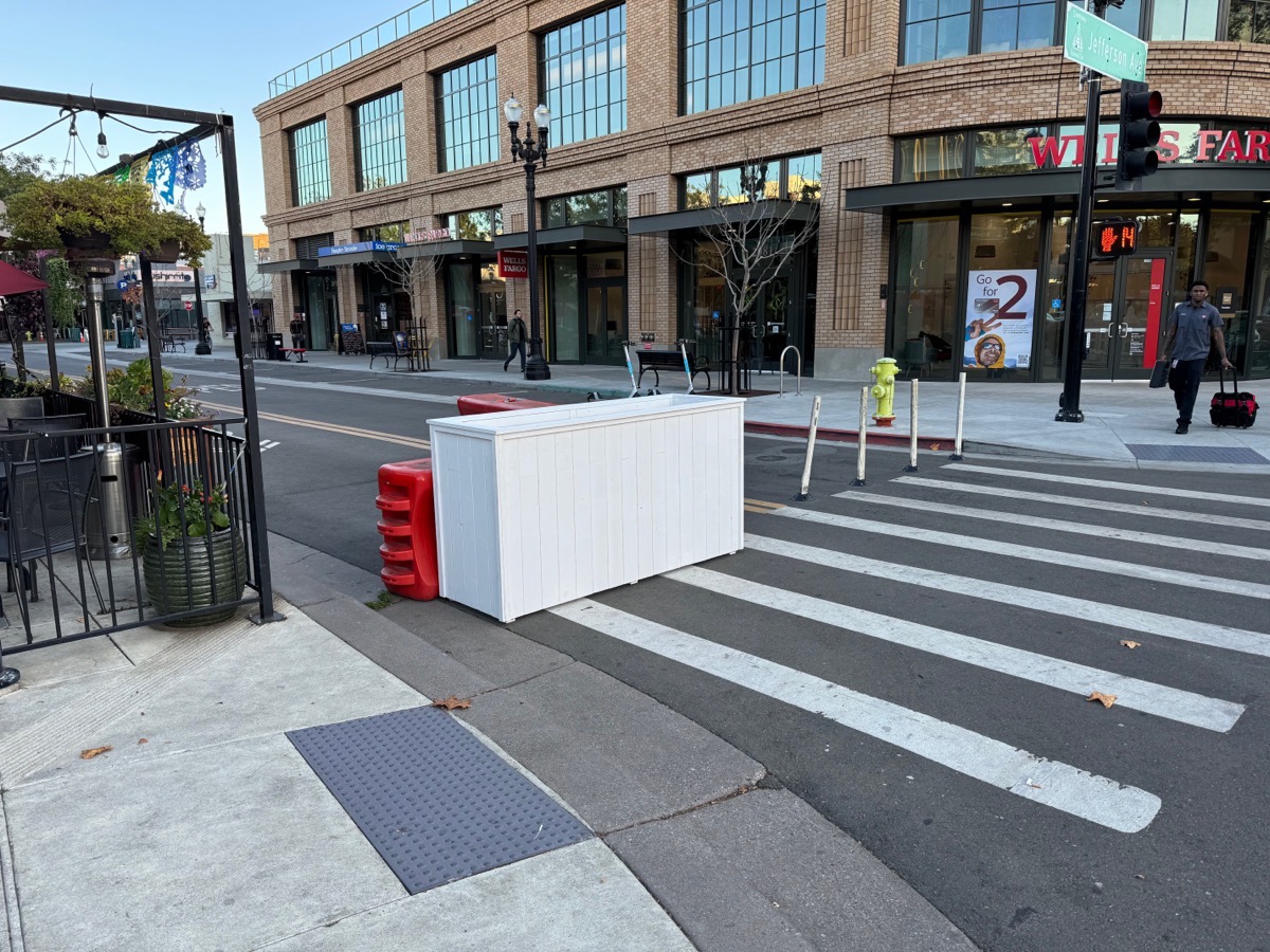
The planter is certainly better looking than the orange plastic barriers that still stand just behind it.
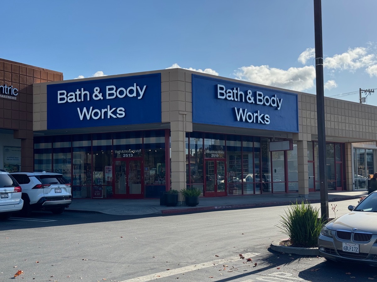
Finally, a couple of quick updates. First, Redwood City’s new Bath & Body Works store is finally open, in the Target shopping center where the Men’s Wearhouse store used to be:
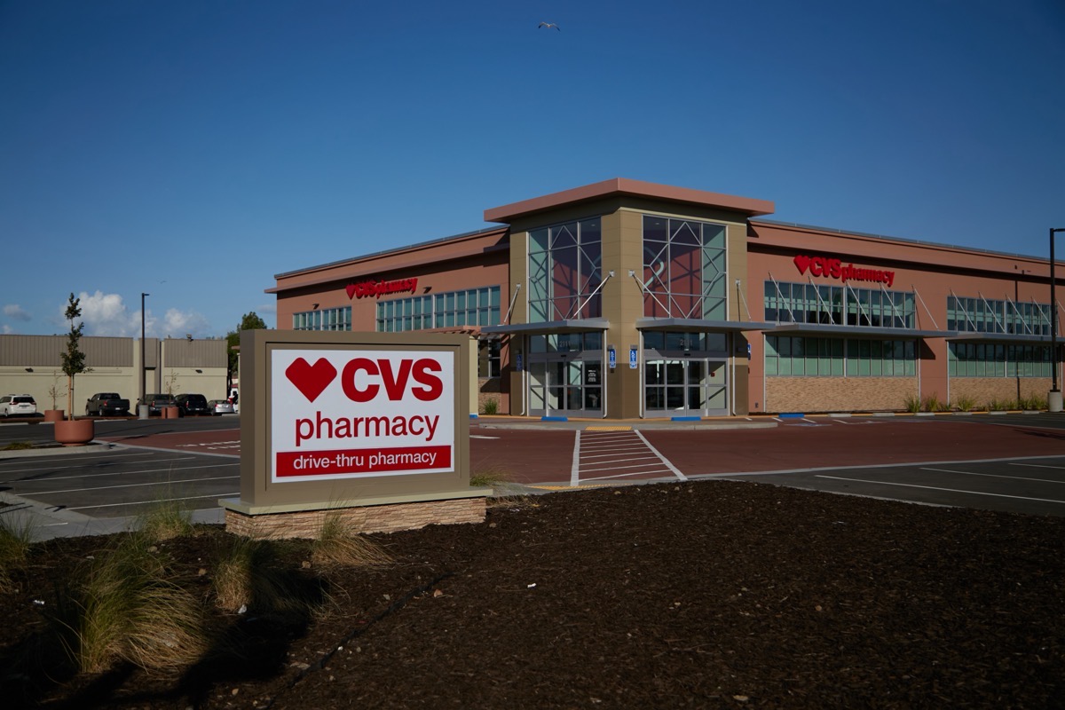
Next, although there has been no real visible progress inside of our new CVS Pharmacy store (on Bay Road at Woodside Road), stand-alone signs have been erected:
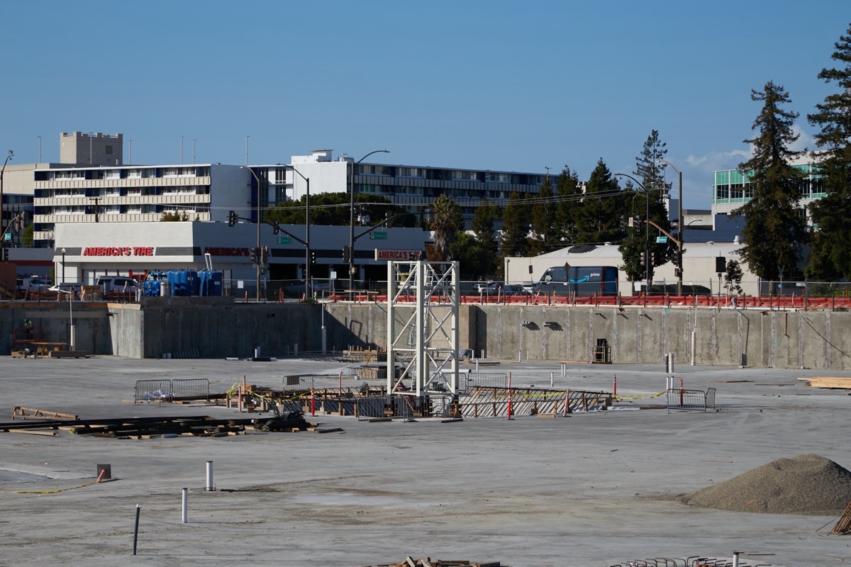
Across the street, installation of the tower crane that I’d guessed might be used to build the three residential buildings on the Broadway Plaza site has begun:
Finally, when I went by the Veterans Memorial Building/Senior Center project for my weekly check-in, I was delighted to see that the solar panels were being installed on the roof:

I am really looking forward to seeing this project completed, hopefully sometime next year. In the meantime, I need to haul out my old turntable and spin some 45’s…

Ask you history center. They know the most obscure things.
Love,
Cousin Karen
They do indeed! Thanks for the suggestion, cousin!
Regarding the white planters on Broadway by Wells Fargo, San Carlos has installed many of these at Olive and Laurel. They look nice. I hope Redwood City will install more and make it look just as nice.
Agree. I’m really curious to know if the city put that there, or perhaps Margaritas, the restaurant immediately adjacent to it.
San Mateo County has a document that may be helpful.
Click to access Appendix_E_Bikeway_Signage_Sept2011_FINAL_1.pdf
Regarding bike path signage.
That is indeed helpful! Great find. It certainly has good details about the signs themselves, and seems to confirm that 45 is indeed a route number. The route numbers listed within don’t appear to match up with route 45 through Redwood City (I need to study it a bit more thoroughly, in case I’m missing something). But this is probably an older document, and the routes were re-numbered when the signs were actually manufactured. Thanks!
Here’s a guide to signage in general https://nacto.org/publication/urban-bikeway-design-guide/bikeway-signing-marking/bike-route-wayfinding-signage-and-markings-system/ . Similar signs exist in San Francisco, but as the guide mentions route numbers aren’t helpful to people with no map or other information . It seems like adding QR codes with links to more information would be helpful these days.
That is indeed helpful. I’ll bookmark that one for future reference. Thanks!