
I’ve been fascinated with those parts of Redwood City that are up against the water for almost as long as I’ve lived here — which is quite a long time now. Having been fortunate to work for NeXT Computer back in the day, when its offices were located on Chesapeake Drive right alongside the Redwood City Municipal Marina, I spent many a lunch hour exploring not only the Port of Redwood City, but the developed lands around our offices and the (then) mostly undeveloped land up along Maple Street. These days, much of the land along and near to Maple Street, in an area known as the Inner Harbor, is in some phase of development:
- In 2015, the Maple Street Correctional Center was built on land just east of Highway 101 and south of Maple Street, at 1300 Maple.
- 275 Blomquist (formerly, a portion of 1402 Maple) recently became the home of San Mateo County’s new Navigation Center.
- 1548 Maple Street has been prepped for a 131-unit townhouse development.
- Seven or so properties along Blomquist Street — where Malibu Grand Prix, Malibu Golf & Games, Lyngso Garden Materials, and other businesses once operated — will soon be redeveloped as the large Harbor View office complex.
- Within the next couple of months, the LifeMoves Maple Street Shelter, at 1580 Maple St., will be torn down, and shortly after that Blomquist Street will be extended past the shelter and up to the southern bank of Redwood Creek. In the next year or two, construction should get underway on the site for a new permanent affordable housing project.
In addition, Granite Rock for years has operated a set of materials processing facilities along Blomquist Street, and since the early 1990s the Redwood City Police Department has had its headquarters building at 1301 Maple Street. As well, the Bair Island Aquatic Center (BIAC; formerly the Stanford Rowing Club), which was formed in 1999, continues to operate out of some rudimentary structures between Maple Street and Redwood Creek, on land it leases from the city.
With all of this, you might think that there surely isn’t much property left to be developed in that part of Redwood City. But you would be wrong. The city of Redwood City has owned property in the area for a number of years, and although the recent land swap with the County of San Mateo that enabled the creation of the Navigation Center left the city with a bit less than they had before, the city still owns (or at least controls) a handful of parcels, nearly all of which abut one another. Today, it appears that the only discontiguous parcel that the city owns in that part of Redwood City is the two-acre parcel upon which the LifeMoves Maple Street Shelter currently sits. Blomquist Street is slated to run through this parcel; once that street is extended to the creek, that parcel will still have about 1.3 acres free, land which will be leased to the county for their planned affordable housing project.
As for the handful of contiguous parcels that remain available for reuse, here is an old satellite view of a portion of the area, with the sum of those parcels highlighted in green:

Before I get into the green portion of the above image, note that this image was captured back when Docktown Marina — those boats along Redwood Creek in the upper left corner of the image — was still in its glory. Most of those boats are long gone. Also, the future townhouse buildings have been added to this image; those white rectangles in the left quarter of the image do not yet exist, although the land is clean and clear. Finally, near the center of the image the portion labeled “Non-Green Area” is what the county obtained in the land swap; it has since been redeveloped as the navigation Center.
As for the land highlighted in green, that is owned (or at least controlled) by the city, and, except for BIAC (which is located mostly within the highlighted area, at the top center, where the Y-shaped dock can be seen), is undeveloped. The structures you see in the highlighted area towards the right are temporary buildings, some being used by a rowing organization and others that have been used as construction offices for, first, the construction of the Correctional Center, and then for the Navigation Center. These latter structures, at least, can (and surely will) be removed at some point.
Highlighted in green is a nice “10-acre” (by my count, it is more like 9.5 acres) plot with a great deal of frontage along Redwood Creek. It appears that the city intends to turn much of this land into a public park, which of course would be wonderful for the many people that will soon be living in the area (between the Navigation Center, the townhouse complex, and the affordable housing building, there will be nearly 500 housing units of various sizes out there). It also, of course, should be wonderful for those of us who don’t live out there, depending upon the amenities that this new park will contain.
Even if it is truly only 9.5 acres in size, this still could be a terrific park. Although, I need to note that both BIAC and Norcal Crew (a “nonprofit organization dedicated to the development of youth through the sport of rowing”) currently operate within the area, and I expect that one or both will remain. Not only does that shrink the size of the park by something like 1.3 acres, it almost completely cuts off park access to the water. Only the bit at the left, where just a tiny shadow of Docktown yet remains, is almost guaranteed to provide public access to the water itself. Today, there currently is an old boat launch ramp there, and so far it appears that the city intends for it to remain, although updated and possibly accompanied by some seating steps or some such amenity. Also, the San Francisco Bay Trail will run through this park and along Redwood Creek (where Docktown is in the above image) to the pedestrian/cycling bridge that crosses over the creek today. So there would be opportunities to enjoy the waters from that trail and from the bridge, in addition to the area around the boat launch ramp.
Back when Redwood City and San Mateo County were contemplating their land swap, Redwood City hired a consultant to help with the process. As part of their work, they threw together a rough sketch that showed what a park on the land remaining after the swap might look like. Although their sketch was very preliminary and may or may not look anything like the final park that the city hopes to someday build on this land, it is nevertheless instructive in that it shows just how many activities could be supported. Here is that sketch:
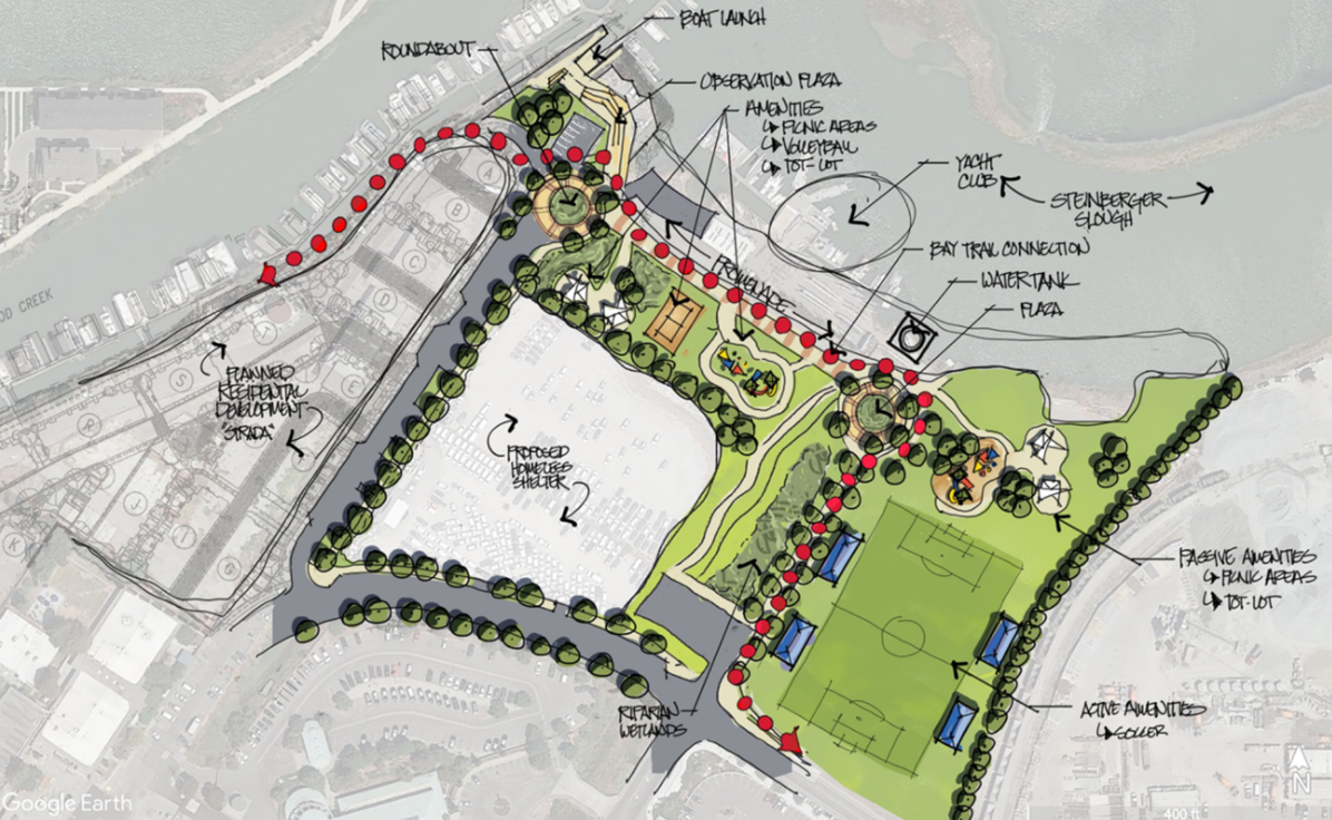
The park, of course, is the part in green; although the sketch shows a roughly rectangular area, the whitish chunk in the lower left of the rectangle is in fact the location of the new Navigation Center.
In this drawing, note that Maple Street, which in the earlier image ran through (and made a left turn in) the area designated for the park, is largely gone. Thanks to the Blomquist Extension — the dark grey street shown along the bottom edge of the park sketch — and a different, recently rebuilt, section of Maple Street (the dark grey street branching off of Blomquist and running between the Navigation Center property and the privately owned land where the townhouses are to be built), access to the boat ramp (where the sketch shows a roundabout) and to BIAC is maintained. Thus, that L-shaped section of Maple Street that today runs through the future park lands could indeed be abandoned, and turned into a part of the park. In the sketch, the Bay Trail — highlighted with red dots — follows the portion of Maple Street to be abandoned.
In the sketch, also note that BIAC remains (labeled “Yacht Club”): it is outside the green park space. The sketch also seems to show a small rectangular parking lot next to BIAC, presumably for that organization’s use. As for amenities, whomever drew this sketch imagined a soccer field, picnic areas, one or more “tot-lots,” and a volleyball court. Oh, and an “observation area” next to the boat launch, where one can look out at the water and see rowers and birds.
This sketch, of course, is the product of just one consultancy’s imagination; in reality the park may contain entirely different amenities, and may be configured entirely differently. But I find it encouraging, and helpful when dreaming about what can be done with the land we have. Which is good, since if you visit the site today it looks absolutely nothing like a park.
I encourage everyone to pay the site a visit, in preparation for a future public input phase of a planning process for this new park. For those that cannot, though, allow me to show you what the place looks like today.
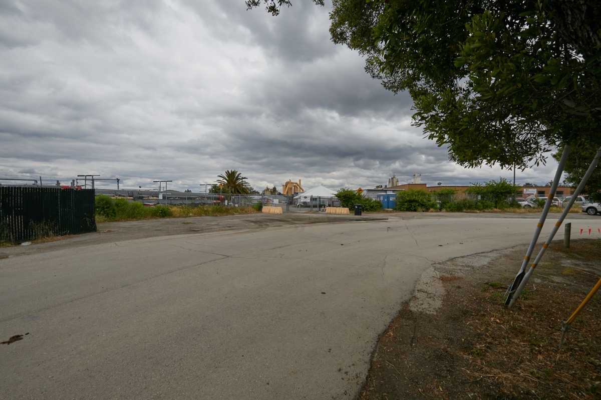
First off, where the park sketch shows a soccer field, today there is a fenced gravel lot that until recently was the location of Redwood City’s RV Safe-Parking lot:

Following Maple Street (the rather prominent road in the above image) to the left, you come to where Maple Street makes that left-hand “L” through the park. This is where Norcal Crew is located, and where the county contractors still have their construction trailers:
(The construction trailers are the brown structures to the right; Norcal Crew is dead center, where the white tent can be seen. The dark fence at the left side of the image is the start of BIAC.)
Before proceeding further, I need to point out that between Maple Street and the Navigation Center there is a small wetlands area that is largely composed of a small gully. Those wetlands would likely remain; they are shown in a somewhat darker shade of green and labeled “Riparian Wetlands” on the park sketch. Until recently, the gully was quite overgrown, and full of trash. With the completion of the Navigation Center, however, the trash was cleared out and the plants cut back, making the area much more visible:
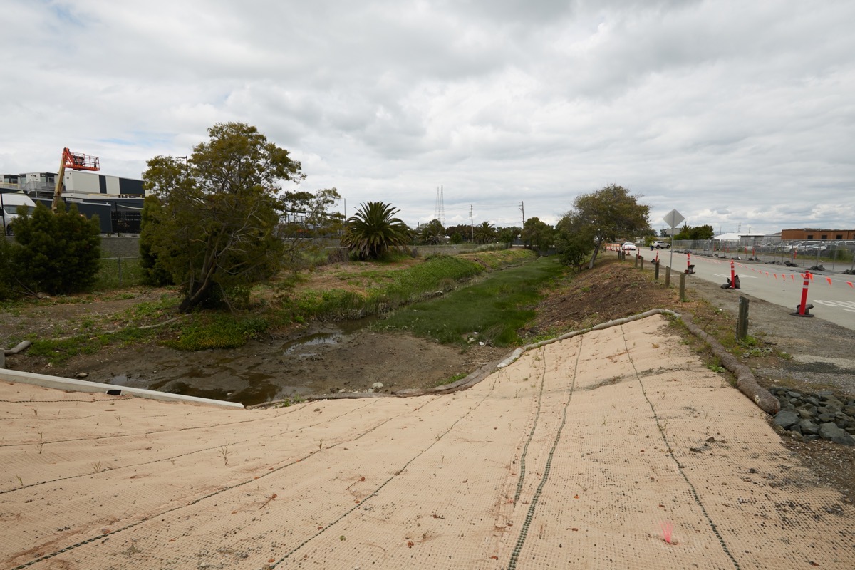
(I took the above image standing on the new bridge that was constructed as part of the Blomquist Extension; Maple Street can be seen to the right, and the Navigation Center is to the left.)
Today there is a good-sized pond on the east side of the Navigation Center; in the park sketch, at least, that pond is no more. I don’t know if the pond is simply an artifact of construction, or is an actual part of the wetlands area. If the latter, I have to wonder if some or all of it will need to be preserved. If so, it’ll take a large bite out of any future park. In any case, here is what that pond looked like when I was last there:
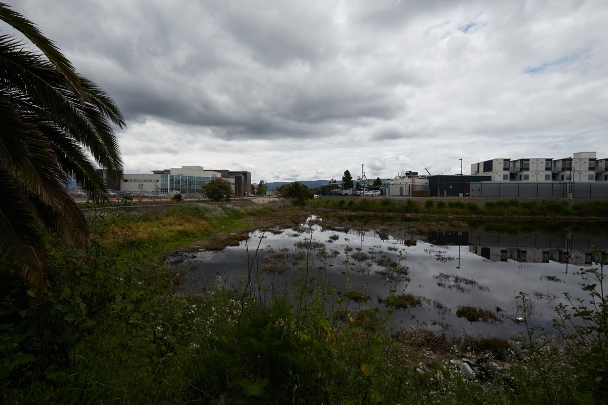
On the park sketch, this pond is roughly where the central picnic areas and tot-lot are shown.
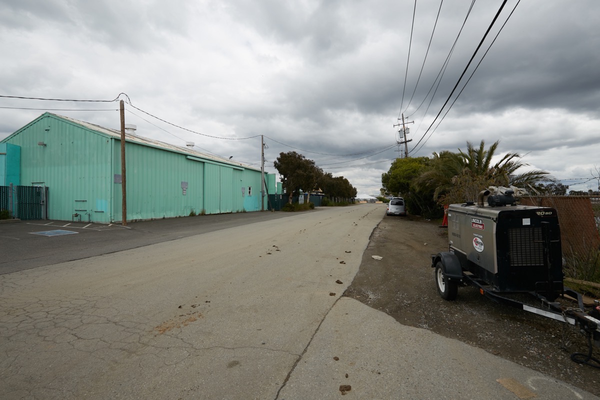
The above image shows the section of Maple Street that runs horizontally across the green highlighted area. That turquoise-colored building is part of BIAC (and thus the waters are just on the other side of that building), and the pond and some land that was used for staging of equipment and materials for the construction of the Navigation Center is mostly off the right edge of the photograph. As you can see, Maple Street is not very pretty here; eliminating it wouldn’t be a big loss, in my opinion.
Finally, I took this picture standing on the newly rebuilt section of Maple Street that runs between the Navigation Center and the townhouse development property:

This is the section of street that runs to the LifeMoves shelter (behind me) and would provide access to the boat launch ramp and to BIAC if the section of Maple Street in the prior photograph was abandoned. In this image, you can just see the waters of Redwood Creek (dead center) and, to the left of those waters, the “historic water tank” (that is indeed old, but may or may not have held water). The tank has been preserved throughout all of the recent construction, and will likely be featured in the new park (maybe in this location, maybe elsewhere; it has been moved around quite a bit during construction and was not originally on this spot).
Here I’ve zoomed in on a portion of the previous image:
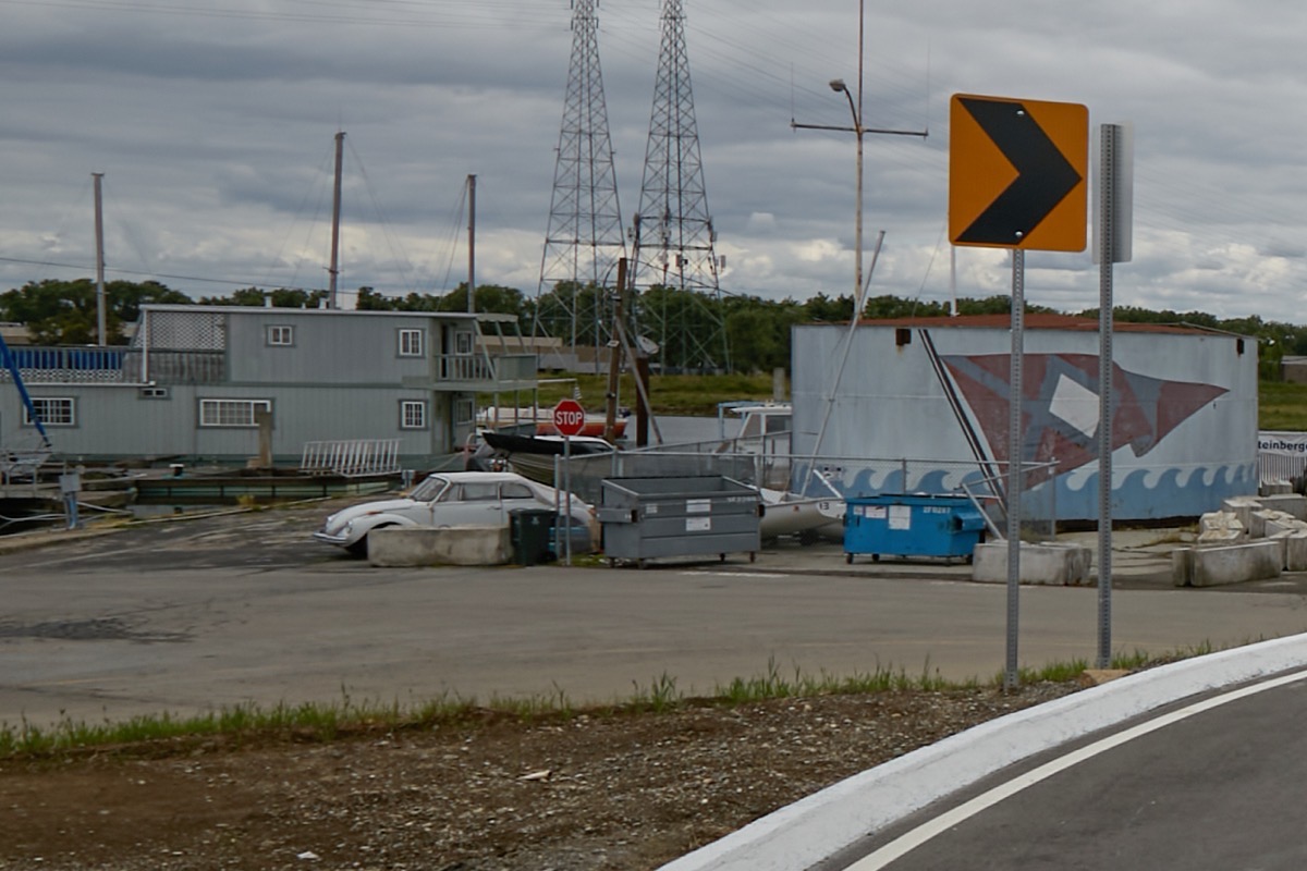
See the stop sign in the center? That gap, between the water tank on the right and the two-story floating home on the left, is the boat launch ramp. That is presumably where the rebuilt launch ramp will stay. But, of course, the area surrounding it will likely look quite different….
I for one would love to see a park out in this part of Redwood City. Not only would it provide more places for us to spend time out-of-doors, it would do so along the waters of Redwood Creek. And it would have the benefit of cleaning up some rather unattractive city-owned parcels, and in general improve the feel of the area. Back in early 2021, the Redwood City Council budgeted $50,000 in one-time funds to pay for planning studies for this future park land. Under the auspices of the city’s Parks and Recreation Commission and its Planning Commission, a process of public engagement was supposed to have gotten underway in the spring of 2022 — but of course that seems not to have happened. Hopefully, the delay was simply due to COVID and/or all of the construction activities in the area. Now that those seem to mostly be behind us, I for one am hoping that the city will get back on track and start asking us members of the public just how the land should best be used. Once that input has been gathered, the city would hire a planning consultant who will draw up a plan, after which — assuming funds are available, of course! — the park will be built. Given that the whole process is likely to take a couple of years, the sooner the city gets started, the sooner we can have our new park, down by the riverside.
My wife and I have a regular volunteer job packaging up and shipping out books that have been donated to the Library, books that have been posted on Amazon for sale. Ours is just a small part of the total effort to raise funds for and otherwise support Redwood City’s excellent system of public libraries. If you have a bit of free time, and are so inclined, please take a moment and look into Friends of the Redwood City Public Library. The work is fun and easy, and I can attest to the fact that you meet some great people. If you are interested or have questions, simply email friendsofrwclibrary@gmail.com and they’ll help you out. Finally, for those who simply don’t have a spot of free time, please consider joining the organization and making a donation. It is a terrific organization, and a very worthy cause.

I haven’t been there for a few weeks, but I am looking forward to the wetlands being more interesting. Cleaning out the trash already makes it look better. Whenever I bike over to Bair Island I stop at the bridge to the police dept to look for birds in the channel. There are lots of shrubs along it, including native species. The “best bird” I’ve seen there is a green heron.
am I the only “old” resident who is worried about bay water level rise?
I’m sure you are not. But do check the site out for yourself: the condo site and the Navigation Center site were both elevated significantly (I believe that the condo site was raised something like 14 feet above water level) and the LifeMoves shelter site will also be raised prior to construction of any affordable housing project. Not sure about the park site itself. FYI, if you take a careful look at the picture where I’m standing on the newly paved part of Maple Street (looking towards the water tank, among other things), you may be able to tell that the street has been raised to the level of the condo project site. So these projects will not only be protected for many years to come, they will serve as a small part of a barrier protecting the rest of the city as well.
Thanks, Greg, for the quick response to my worries…..at my age I won’t feel the impact of all these new buildings but my grandchildren surely will; hope it will be a positive one!
I hope so too! Mother Nature is indeed not to be trifled with…
Imagine what this area could have been if it wasn’t for the unnecessary eviction of the Docktown community to the tune of $25M+ by Redwood City officials. Forever a black eye in RWC history lead by former mayor, John Seybert.