
Although I often write about Redwood City’s larger projects — all of which continue to hum along nicely — there are of course plenty of smaller things around the city worth investigating. This week I’ll go into a few that particularly caught my interest.
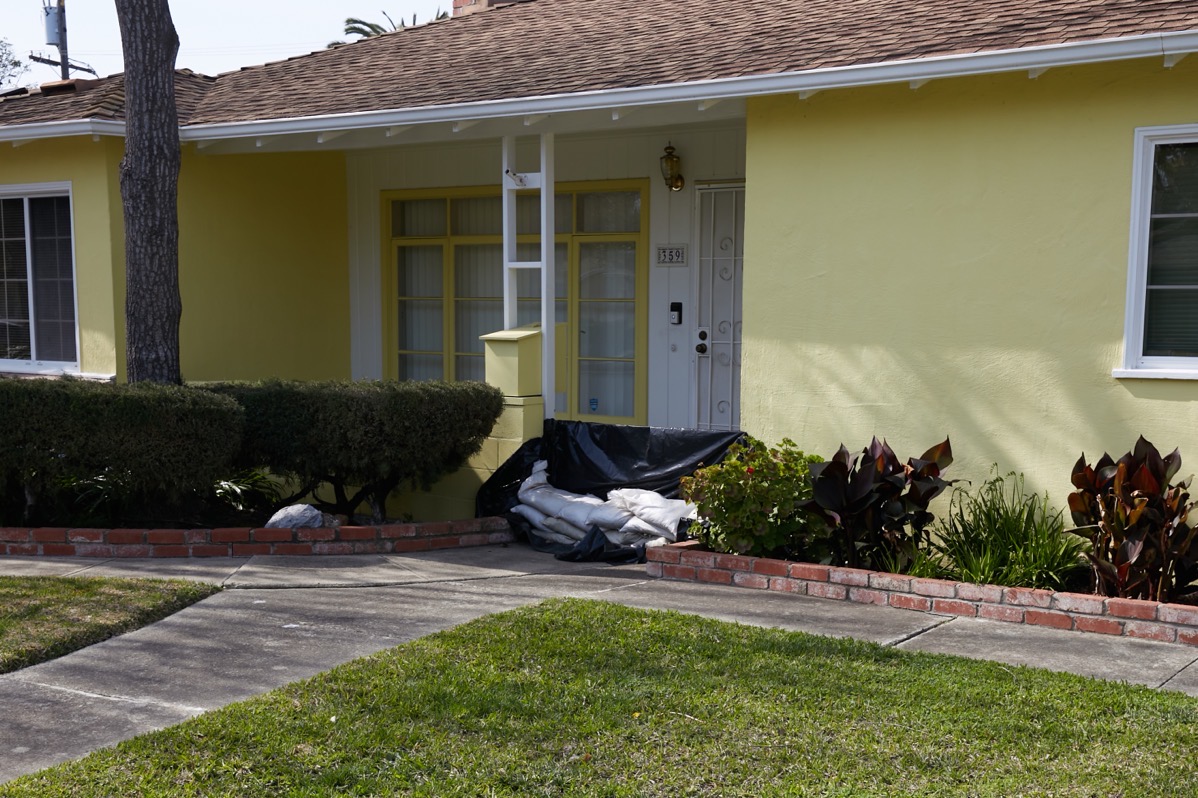
Redwood City has always had some well-known trouble spots when the really heavy rains come. Most often, you hear about the mobile home parks out on E. Bayshore Road, just south of Seaport Boulevard. But recently a new one has cropped up: some of the homes in the “Alphabet Streets” (which run parallel to, and just north of, Whipple Avenue). In particular, G Street, which is the northernmost of the Alphabet Streets and the one that runs closest to Cordilleras Creek. A number of homes back up onto that creek, which apparently has been overflowing recently. The flood waters not only caused severe damage to a number of homes along that street, they seem to have made their way onto the street itself. Here is one of the homes along G Street, still showing the homeowner’s valiant efforts to protect the place from the rising waters:
Here is a view of the creek behind this particular home.
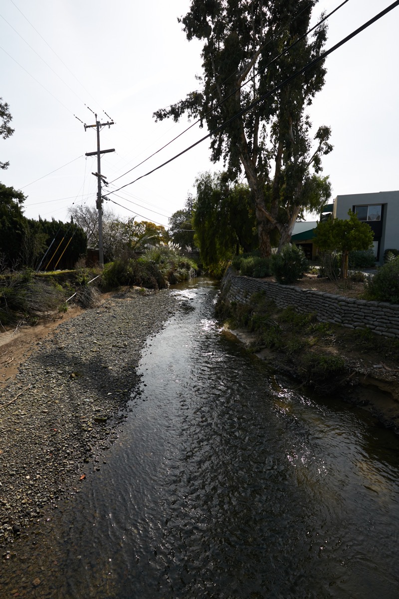
As you can see, the waters have receded and are behaving themselves for the moment — although the creek seems to still be flowing well. More rain is on the way this weekend, but hopefully it won’t be enough to cause further problems.
The above picture of the creek shows where it reaches Industrial Way, on the west side of the street. Cordilleras Creek, in case you didn’t know, largely forms the border between Redwood City and San Carlos. Thus, although the homeowners have rightfully been pleading with Redwood City to help them out, exactly who is responsible for maintaining the creek seems not entirely clear. Parts of the creek form the border, and thus are probably at least somewhat the responsibility of both cities, while other parts lie entirely within the boundaries of one city or the other (just a bit west of Alameda de las Pulgas, the creek runs entirely through an unincorporated part of San Mateo County). The following map shows the creek running from just west of El Camino Real (at the bottom of the image) out to Highway 101 (near the upper right corner). The area shaded in yellow is Redwood City, whereas the portion shaded in brown is San Carlos.
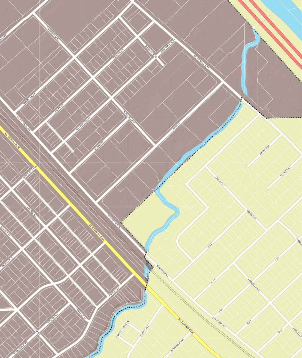
After the creek crosses beneath El Camino Real and the Caltrain tracks, it jogs around Redwood High School before once again running close to, if not directly on, the border between the two cities. After it crosses Industrial Way, it is entirely on land controlled by the City of San Carlos.
As the homeowners who live along the creek have discovered, the politics of creek management can be quite murky. The responsibility for the maintenance of the creek apparently lies with some combination of the homeowners, the two cities, and even a state and/or federal agency or two (waterways in the United States always seem to be controlled to some degree by an obscure set of agencies at the state and federal levels). Thus, cleaning up the creek (or dredging it, or whatever is needed to alleviate this particular problem) is not nearly as simple as some would like it to be, unfortunately.
Cordilleras Creek is quite beautiful, but sadly there are very few spots where one can actually see it. I did take some pictures where it crosses beneath Old County Road (just south of Redwood High); that’s one of the best places for one to view the creek. There, you’ll find a number of eucalyptus trees lining the creek banks: trees that drop copious amounts of leaves and, I believe, shed their bark. All of that presumably makes its way into the creek, adding to material washed down from further upstream and helping to cause the trouble that our Alphabet Street neighbors have been experiencing.
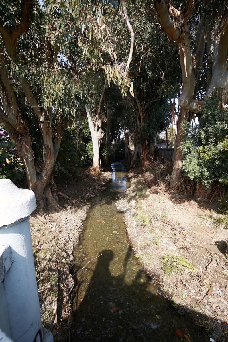
It sure looks pretty, though…
In a comment to last week’s post one reader noted that the recent storms had caused further damage to the already fire-ravaged McDonald’s restaurant building on Woodside Road at Nueva Avenue:
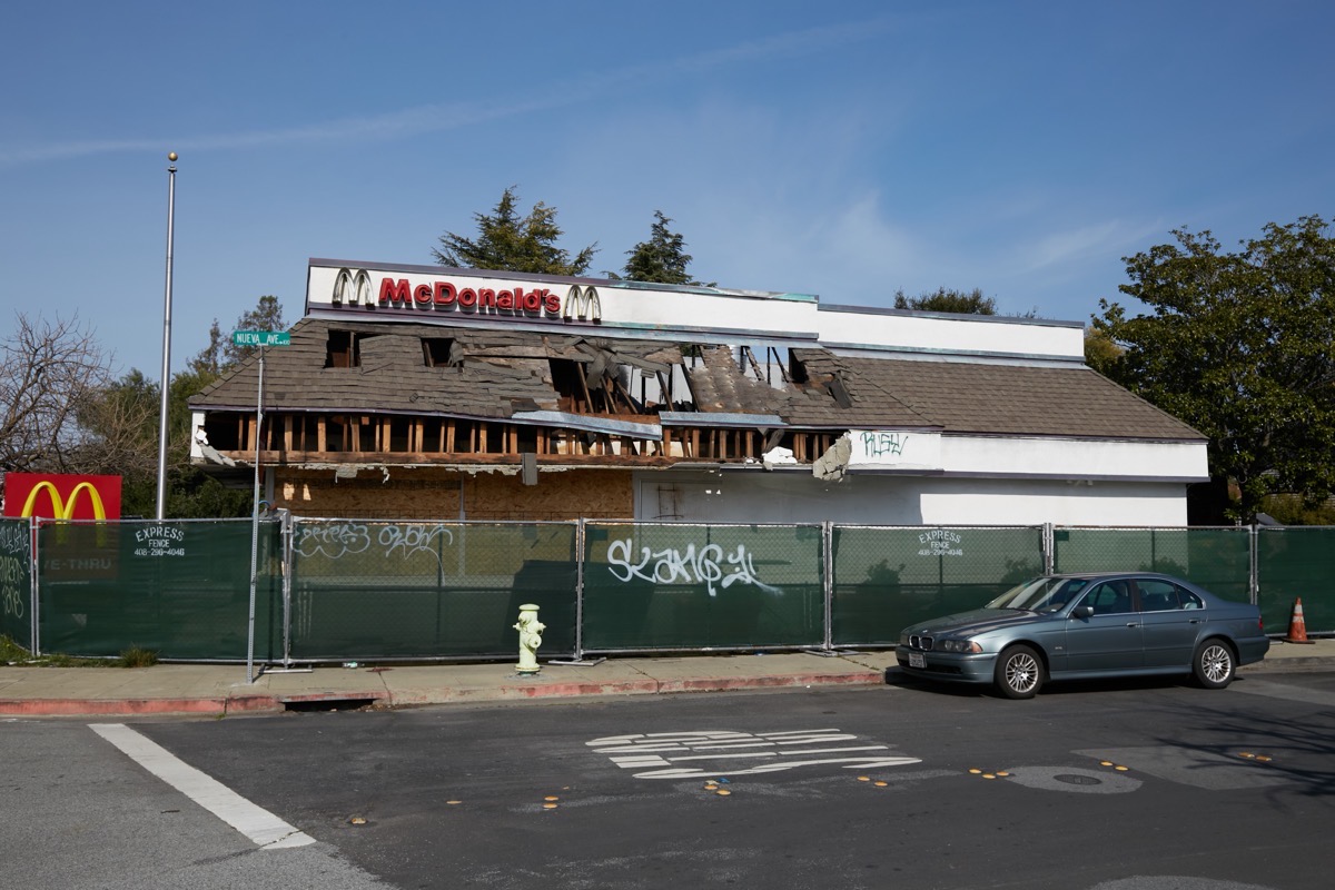
They inquired as to whether I thought the place would ever be rebuilt, and rightly noted that it is a real eyesore. A quick check of the building permits for the site revealed that the building’s owner applied for a permit to demolish the building back in early December, and that the permit was approved by the city in mid January. The permit, interestingly enough, isn’t to completely scrape the property clean, but is to simply take down the building and leave the foundation. All utilities are to be capped, and the driveways and parking areas are to remain as-is.
I was interested to note that as yet a permit to construct a new building on this site has not yet been filed. Thus, although we won’t have to continue looking at this eyesore along Woodside Road for much longer, I don’t expect to see a new building rising on the site anytime soon. The fire occurred in the early morning hours of August 7. Thus, it took exactly four months for the property owner to decide that the building couldn’t be salvaged. This demolition permit, because it leaves the foundation and utilities, gives hope that a new McDonalds might be built on the site, but doesn’t guarantee that. I wouldn’t be surprised if the plan is to simply clean things up to where people aren’t complaining, and only then decide if it is worth building a new restaurant (McDonalds or otherwise) — or whether the property should be sold to a developer for some other purpose. We’ll know once we see a building permit for the site, or when some other project is added to Redwood City’s Development Projects list.
Oh, and my commenter noted that “they’ve never even cleaned up all the garbage they took out of the building, still in the parking lot behind the temp fence!” About that, we can put our minds at ease: while I was there (today) taking pictures, I noted two people actively cleaning up the garbage around the building. They weren’t part of a demolition crew, but were picking up and sweeping up trash and putting it into appropriate receptacles. So at least it’ll be a clean mess, until it is torn down (which hopefully will be soon, given that more storms are coming that might further damage the already damaged building).
This week I dropped by the large affordable housing project at 353 Main St., mainly to check in on the progress being made on the bit of “Redwood Creek Trail” that will run between the building and the creek. Although I was pleased to see that the concrete for the trail had been poured, and that it neatly connects to the bit of trail that runs behind the next-door Township Apartments building, I was less than excited to see that what they’ve constructed doesn’t seem to match up very well with the landscape plans for the building.
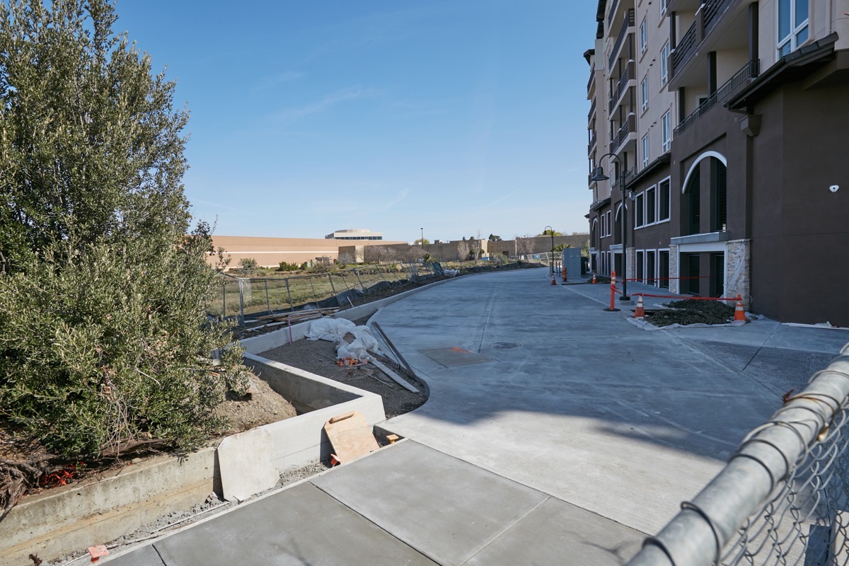
Aside from that tiny planter along the left side of the walkway (where you can see some strips of wood and a bunch of plastic) everything else appears to be concrete. Whereas the plans clearly call for a “10’ concrete sidewalk and 2’ wide decomposed granite paths on both sides, per city standards.” Those plans also call for some trees in this area; there might be a couple of tree wells up against the building that I’m just not able to see from my vantage point, but that’s about it. So although this new bit of trail will be very functional (and will do a great job serving as an emergency access for fire trucks, as intended, should the need arise), it won’t be nearly as interesting or as green as I had thought it would. I’ll still walk it, and I’ll enjoy the unimpeded views of the creek that it’ll provide, but I’m saddened to see a sea of concrete where I thought we’d have “grass pave w/low native planting” as is called out in the plans that were made publicly available.
As further proof that I make it to all corners of the city — if such proof is needed! — recently I made it out to Westpoint Harbor, which is located on the eastern side of the Pacific Shores development at the end of Seaport Boulevard. I was there because I wanted to check on a building project that has been going on for a little while now. This one:
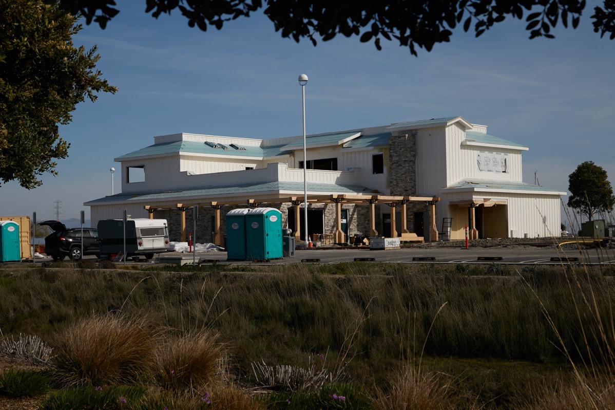
Westpoint Harbor, in case you aren’t familiar, is a privately-owned and -operated harbor for those leasing slips and their guests. When I last checked, it had approximately 270 berths, with plans for a total of 416. Many of those berths serve as home to luxury yachts: this is a high-end (read “pricey”) marina that provides a full set of services to the great many boats that are moored there (some of which can be lived on).
The owner of Westpoint Harbor has big plans for the place. If I recall correctly, they hope to one day build a hotel adjacent to the marina. For now, though, they are in the process of constructing the stand-alone two-story building I showed earlier; it will contain a restaurant on the ground floor and a yacht club on the upper floor. That yacht club space will apparently include a dining room, lounge and bar — and presumably will be for those who keep their boats in the harbor and their guests. As for the restaurant, I’m hoping that it’ll be open to the public. I have good memories of eating at the restaurants that used to be located in the Port of Redwood City (by the Redwood City Municipal Marina on Seaport Court), and I’d like to be able to once again dine while enjoying a view of the bay waters.
Most people know Redwood City by the large development projects that are currently altering the city’s skyline. But there is so much more to the city than that. I plan to continue trying to ferret out the smaller, more interesting things that make the city what it is, but don’t always know where to look. By all means let me know if you are aware of something going on in your neighborhood that I haven’t mentioned! As much as I know about the city, there is so much more that I don’t know about.
If you don’t subscribe to Redwood City’s “eNews” weekly electronic newsletter, I highly recommend that you do. This week’s edition is particularly full of items that’ll be of interest to a wide variety of Redwood City residents. Such as:
- The city is once again recruiting for members of the Architectural Advisory Committee, the Historic Resources Advisory Committee, the Police Advisory Committee, and the Transportation Advisory Committee. Given the city’s greatly expanded eligibility criteria, more residents than ever qualify to join these important advisory bodies.
- The city is looking for volunteers to help with its One Day Unsheltered Homeless County and Survey, which will take place on Wednesday, March 15.
- Monday, March 20 at 6 p.m. the city will hold its annual State of the City address.
- CityTrees is holding an annual Tree Pruning Workshop on Saturday, March 25.
- Also on March 25 the county is holding a Household Hazardous Waste drop-off event in Redwood City. If you have old paint, pesticides, aerosols, car batteries, cleaning products, fluorescent bulbs, or other qualifying hazardous materials that you’d like to get rid of, this free event (reservation required) is a painless way to do so.
If you’d like to subscribe to the eNews, look for the blue “Join Our Email List” link at the top of each edition.

Pingback: Upstream, Downstream | Walking Redwood City
Hi Greg,
The county has started on its carriage house project, and now both sides of Marshall have their sidewalk closed (COB3 project closed it in 2020). Anyone who walks downtown should register a complaint and keep doing so until they figure this out and open at least one side for pedestrians.
> The county has started on its carriage house project
Do you know this for sure? I can’t find any evidence that they’ve completed the necessary fundraising, but that could just be me. I do see a recently approve permit enabling PG&E to relocate a (possibly underground) transformer, which may be needed to clear the way for the carriage house; that may well be what is about to happen on the site.
Whatever the project is, you are right that the construction fencing not only blocks the sidewalk but some of the street parking, too. And indeed, with the County Office Building still under construction, there is now no safe way for pedestrians to navigate that particular block. That certainly is annoying (I often walk along that particular section of Marshall Street) and will force me, at least, to detour through Courthouse Square. It seems unfortunate that they couldn’t have put in a temporary walkway on the street alongside the fencing using plastic barriers, as has been done with other projects, but there may not be enough room for both cars and peds (especially when one considers that fire trucks often drive along that section of street).
Thanks so much for pointing this out. Lately I’ve been walking in a different part of town and hadn’t yet seen this.
Thanks Greg, love all the info.
Speaking of all corners of the city, and Seaport Boulevard in particular, I’ve been curious about the status of an undeveloped large parcel of land for a long time: the former location of the Cargill salt pile, located by the Seaport Centre at the end of Chesapeake Drive. As far as I can tell, it has been closed off and undeveloped ever since Cargill ceased operations many years ago. There are signs along the fencing that say “Private Property – No Trespassing – Abbott Laboratories.” A quick google search led to information detailing Abbott Labs’ extensive plans for a “West Coast Research Center” from around 2003/2004. However, as far as I can tell there haven’t been any updates more recently.
It’s a huge plot of empty land in an otherwise pretty busy area that seems like it would be valuable to develop. Any idea what’s going on here and why Abbott is sitting on it, and whether it will ever be developed/repurposed?
Cheers,
David
Thanks for bringing this up. My research agrees with yours: Abbott bought the land (and the pier) from Cargill with plans to expand their presence in Redwood City. However, after a favorable EIR (Environmental Impact Report) and, I believe, project approval from the City Council, Abbott never went ahead with the project. They still own the land today, but if they wanted to build on it they’d have to go through the full approval process once again, so we’ll have advance notice if they (or anyone they might sell the land to in the future) decides to do something other than just sit on their property and wait for the opportune time to develop it. I have no information on why they continue to just sit on the land. I’m guessing that a year or so ago was probably when that valuation peaked and when they should have sold it (or developed it), although it remains quite valuable. They may still be holding it in anticipation of future growth needs: if they sold it and then decided in the future that they wanted to build a campus here, they’d have to pay a lot of money to buy or lease a site.
I have great memories of that salt pile. I used to work at NeXT, and for a time in late 1996/early 1997, after we were sold to Apple but before my office was moved to the main campus, I had a second-story corner office at 900 Chesapeake Drive looking directly at the pile. I spent a lot of time watching a guy on a tractor driving up and down it, reshaping it and helping to feed the salt into the conveyor that transported the salt into the hold of a waiting ship. Particularly in the summer, I imagine that the conditions for that guy must have been quite uncomfortable, what with the glare and the heat being reflected from the pile. It made me truly appreciate being able to be inside, in air-conditioned comfort, behind tinted glass…
tks one of your best…….your neighbor, brent britschgi