
One of the things I’ve grown to really appreciate about this blog is the community that has grown up around it. I seem to have developed a great group of readers, a number of whom seem to enjoy commenting on my writings. Often one of my readers will respond to another reader’s question before I have a chance to get to it — which is wonderful! Less work for me…
I’ve gotten some great ideas for blog posts from some of my readers, and I’ve investigated a number of things in response to requests from others. While I absolutely cannot promise to answer every request, or even respond to every comment or suggestion, I am always open to new ideas and new things to dig into. Feel free to share your requests and ideas either by leaving a comment to one of my blog posts, or by sending an email to greg@WalkingRedwoodCity.com.
Although I normally write every single blog post myself, and take almost every picture, sometimes I hear from someone who has the means to take a photo that I simply cannot take myself. For instance, in the past I’ve written about the project to transform the old Elgin’s Auto Supply and Machine Shop building at 55 Perry St. into a small office building. Before and during the construction process I made repeated visits to the site, and walked around as much of it as I could in order to take photographs. But one of the rather special elements of that project is its private rooftop deck, something I simply couldn’t photograph from the ground. Fortunately for me, the owner of The Hub, a bar and café located at 2650 Broadway, is a reader, and offered to go up onto his roof and take some pictures from there. They did so on three separate occasions, allowing me to publish images such as this one, which he took while the building was still under construction:
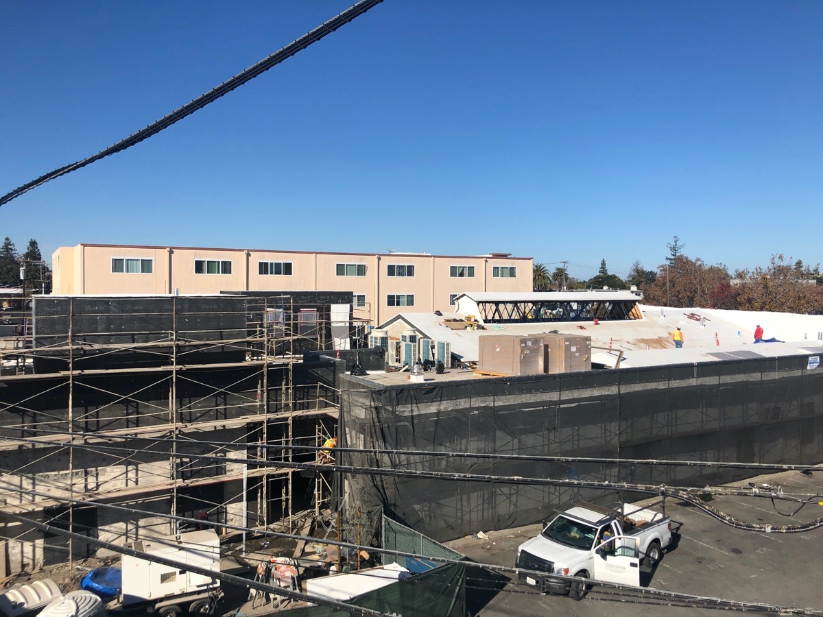
Although the rooftop deck is largely behind that wall you see sticking up in the left half of the image, their photos nevertheless provide a rather unique view onto a project, a view that I otherwise wouldn’t have been able to provide.
This week, similarly, one of my readers asked if there was anything that his teenage son, who has a drone that he loves to fly, could do for me. Not having one myself, I of course jumped at the chance to send him out and get some aerial photographs of some of Redwood City’s more interesting projects. I suggested starting with the small single-family housing development being constructed up in Emerald Lake Hills (along Jefferson Avenue just past Redwood Parents Nursery School), since I’ve been meaning to head up there and check on the project’s progress anyway, and this would save me a strenuous walk.
Sam Johnson, our intrepid young pilot, responded quickly with a number of really terrific pictures. For instance, in addition to a couple that show close-ups of the individual houses under construction, he provided this (relatively) high-altitude shot showing the entire parcel and the three houses that are currently under construction:

These houses are being built by Edenbridge Homes, and are part of what ultimately will be a 9-unit subdivision called Wika Ranch. Six of the development’s 4- and 5-bedroom homes will be accessed from the cul-de-sac (“Wika Ranch Court”) you can clearly see in Sam’s photo, while the other three — the three currently under construction, in fact — will be accessed from Jefferson Avenue. Wika Ranch actually seems to include a 10th home, but that one was completed and sold some time ago. It has a Fallen Leaf Way address, and can be partially seen in the above photograph, on the right edge near the upper right corner.
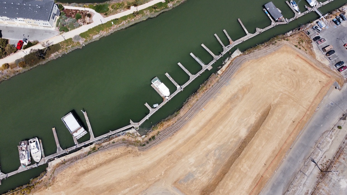
That one site was all I initially asked Sam to explore, but he and his dad anticipated my future wishes and went on to also take aerial photographs of the Strada project out on Maple Street by Docktown Marina and the Broadway Plaza project on Broadway at Woodside Road. First up, Strada:

Strada Investment Group’s project occupies an unusually shaped parcel: it is basically a right triangle, with a square chunk taken out of the “heel” where the triangle’s right-angled corner would be. The above photo show that end of the triangle; note the currently developed “chunk” that today is home to the LifeMoves Maple Street Shelter. Although the Strada project — which will one day soon consist of 131 townhouses — will be built on land owned by Strada Investment Group, the shelter sits on land that is owned and controlled by San Mateo County. The county is currently in negotiations with Redwood City over this bit of land and a city-owned parcel nearby. The plan, if all of the details can be worked out and agreed upon, is to swap some or all of the city’s parcel for some or all of the county’s, enabling the so-called “Blomquist Extension” to be built. Blomquist Street, which today very roughly parallels Highway 101 on the east side of the freeway, currently dead-ends into Maple Street close to the Redwood City Police Department headquarters. The city hopes to extend the street alongside the police station, where it will curve to the left (towards the freeway) and then curve to the right (to the north) to run right alongside the freeway until it reaches Redwood Creek (which is visible in the photograph above). In heading towards the freeway, this new bit of Blomquist Street would roughly follow the bit of the street you can see on the left side of the above photo. Then, when it turns north to parallel the freeway (basically, along the top of the photograph, from left to right), Blomquist will have to run across the property that the county currently owns. This is the part that Redwood City is hoping to take ownership of, in exchange for some or all of a parcel at the corner of Maple and Blomquist streets that the city currently owns (and which is temporarily being used as a safe-parking lot for recreational vehicles).
The potential land swap merely affects the fate of Blomquist Street, which, if it is extended as planned, will, for now, terminate close to where the end of the docks near the top of the above photograph. In the future, the city would then, ideally, build a proper bridge across the creek allowing Blomquist Street to connect to E. Bayshore Road by the Boardwalk Auto dealerships. But that’s a project for a future time. For now, regardless of the fate of the land swap, Strada’s project will occupy the neatly groomed land you can see above. Note the fence-lined walkway that runs the length of this part of the parcel: that path is open to the public, and indeed I walk along it frequently. You can get to the northwestern end by walking around the Marriott Hotel and crossing the pedestrian “bridge to nowhere” that is there today. The southeastern end of this path, as you will see, is located on Maple Street, midway down Strada’s property.
Finally, before moving on to the next photograph, I just wanted to point out the many empty slips at Docktown Marina. Soon all of the ones in the above photograph will be empty (and the slips may end up being removed); the floating homes you see in Sam’s photograph are boarded up and scheduled for demolition (or sale, if the city can find someone to buy them). There are still a handful of Docktown Marina residents, but I believe that all of their homes are located towards the other end of the marina, closer to the bay.
Here is a second photograph showing the center of Strada’s property:

Of particular interest here is the path; this shows how it finally comes out at Maple Street. This path, incidentally, roughly follows the route of a new street that Strada will eventually build through their property to provide access to most of the townhouses that will make up the development.
This third photograph shows the eastern tip of Strada’s site. The small parking lot you can see in the upper right is currently for the use of the remaining Docktown Marina residents, but ultimately it will be landscaped, with a portion becoming a small waterfront park that will be open to the public. There also will be a public walkway running the length of the development along the edge of Redwood Creek (which is the waterway you can see in all three of the above photographs). That walkway will connect the waterfront park with Blomquist Street near the bridge across the creek, serving as a key segment of the San Francisco Bay Trail.
Before I leave the Strada project, allow me to dispel a couple of rumors. Strada put in a lot of work to raise their site in an effort to protect it from sea level rise. For the last couple of months, though, there has been little or no visible activity on site, causing some to speculate about what is going on. I recently heard a rumor that Strada is looking to sell the project, and that the city might be interested in purchasing the property. I ran this rumor by the city, and heard back from both the city staffer assigned to the project as well a member of the applicant team. According to the city staffer, who should know, they “have not heard that there is a change in ownership, nor that the City has interest in purchasing the property.” And the person from the development team responded with “we have completed the soil surcharge work and we are currently working with the City, County and SVCW [Silicon Valley Clean Water] to clear a few logistical items that should clear the way for the remainder of the construction. We hope to start the next phase of construction this fall.” Given all that, I think we can safely say that those particular rumors have no merit, and that construction on this project’s 131 townhouses themselves should get underway soon.
Returning to Sam’s drone photos, although one can get a pretty good idea of the status of the Broadway Plaza project simply by driving down Broadway, his aerial photos provide a tremendous overview of this project. This photograph, for instance, shows the Chestnut Street end of the property (Chestnut runs left-to-right along the upper third of the photo, with Broadway running at an angle along the right edge of the photograph, and Bay Road angling in from the left edge):

The above, of course, is just half of the project site; this is where the three residential buildings (one of which will have some amount of retail on the ground floor) will be situated. The project’s three office buildings will occupy the other end of the property, where the CVS drug store still stands today:
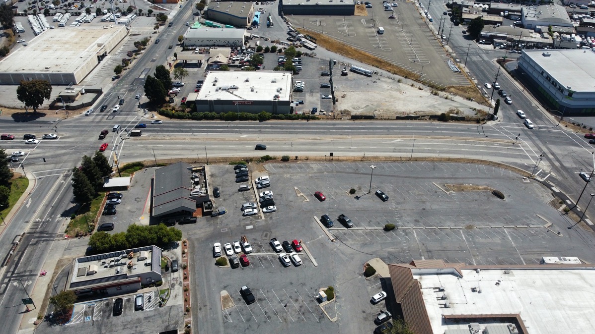
In this photograph, Woodside Road runs across the middle of the image, from left to right. The CVS store is in the lower right corner. Not actually part of the project, but seeming to be part of the project site, is the Jack in the Box restaurant (in the lower-left corner) and, just above that, the Denny’s restaurant. These two restaurants will remain, untouched by this development; it will occupy the entirety of the block bounded by Woodside Road, Bay Road, Chestnut Street, and Broadway except for those two small parcels.
The plan is to build this project in two large phases, with the three residential buildings being constructed first, followed by the three office buildings. In order for the office buildings to be constructed, the CVS building will have to be torn down. But before that, the project’s developer, The Sobrato Organization, intends to move CVS into a brand-new store that Sobrato will build on a site they control directly across Woodside Road from the main project site. If you look just above Woodside Road in the aerial photograph, the white-roofed building you can see against the street is the Smart & Final store. Just to the right of it is a triangular parcel, with the long edge of the triangle defined by an old, abandoned railroad right-of-way. That triangle, plus its counterpart on the other side of the railroad right-of-way that together would form a square, is the site where the new CVS is planned to be built.
That about does it for Sam’s aerial photography, at least for this week. Assuming he is willing, I’ll likely have him go out again at some point in the future; I find the overhead vantage point particularly helpful when explaining some of the projects going on in our area. For now, though, I want to thank Sam Johnson for his many fine photographs (only a few of which I shared here today). Keep on droning, Sam!
Although Sam ended up providing much of the fodder for this week’s post, I did take a lengthy walk this week to check on a number of things. Most of what I learned can be held for a future post, but I did want to highlight one: the Highway 101 Pedestrian Undercrossing project is, at long last, really, truly, about done. I was there on Wednesday and noted that not only is the path now fully in place (even to the point where it has a center stripe!), just look at the neatly groomed soil on either side of the path. The sprinklers are in, and the soil was ready for new plants.

I then had to run by Kohl’s on Thursday (yesterday), and so I made it a point to check on the project yet again, and was delighted to see that a work crew was in the process of installing the plants and trees that will line this new pedestrian and cyclist pathway. And not just the path running from the end of Main Street over to the roundabout between the Courtyard hotel and the Boardwalk Auto dealerships, but also the — for now — somewhat useless bit of path from Main Street extending towards downtown:
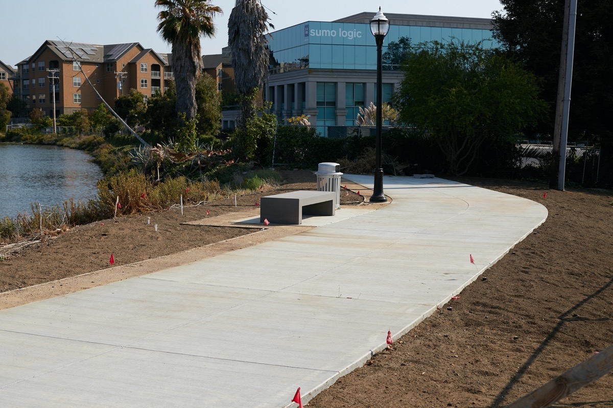
It may be useless at the moment for getting anywhere, but I, for one, will actually use the bit of path in the above photograph, even given that it dead-ends into a fence (for now). That bench is mighty attractive, and will undoubtedly serve as a nice, quiet resting spot when I am out on a particularly long walk. I’m keeping my fingers crossed that the city has plans to somehow extend the path beyond the fence and through the parking lot of the Sumo Logic building you can see above; just beyond that building’s parking lot the path resumes, running behind the brown apartment building you can also see above (those are the Township Apartments, on Main Street). Although that segment of the path currently only runs the length of that one apartment building, just beyond Township a large affordable apartment building is under construction, and that project also includes a segment of this path, one that will connect to the Township segment. So assuming that the Sumo Logic segment can be somehow built, one could walk along this path from the east side of 101 (starting all the way out at Blu Harbor, if one wishes) to the parking lot behind Carl’s Jr. That gets you most of the way to downtown Redwood City, with only a couple of additional segments needed to make for one continuous path (albeit a path with a couple of street crossings, including Veterans Boulevard).
Anyway, given their progress, I expect this path will be opened to the public any day now. I can’t wait…!

From the aerial photos of the Strada project, you can’t appreciate how much the land has been raised to combat future sea level rise. If you drive on inner Maple St, which I did recently, you will see just how high this townhome development will be. It’s almost too high! Residents will be driving/walking up steep ramps to get into their development. Views and noise from the freeway will seem even closer/louder. It’s much closer to the freeway than is the Marriott hotel or One Marina development. Are they going to build a tall sound wall on 101 adjacent to this development? They need to. It’s really, really noisy. If they don’t, this is a terrible place to put new homes. I know we have a housing crisis, but this does not seem well thought out, and maybe they should sell this development and start over again.
It is indeed high; I seem to recall that they had to raise the entire site 14 feet or so. I’ve published pictures before showing that incredible wall they built along Maple Street; it’s really something.
I haven’t found the noise levels to be all that bad, myself, and I have visited the site on foot dozens of times. A sound wall would be up to Caltrans. Next time I go through there, though, I’ll make it a point to pay attention to the sound levels. Thanks for bringing this up. I will note, however, that the sound levels shouldn’t be that much worse than at the One Marina condos just across the creek, or at the Marriott hotel…
14 feet is approx 1 1/2 stories high. That’s higher than some beach houses I’ve stayed at.
If you have to build that high up to accommodate future sea level rise, then maybe you shouldn’t be building housing there. How ironic that boat houses are resistant to sea level rise.
Where I was standing when I was noticing the noise from the freeway was in the parking lot of Sports Basement on the other side of Strada. I had parked in the closest row to the freeway (farthest from the store), and I was looking over the freeway onto the site of Strada. The noise in incessant. If you can’t block it out, then it’s really bothersome.
The raising of the land for the Strada development is eye-opening, indeed. While developers east of 101 will be on the hook for improvements to their property that mitigate against sea-level rise, the bigger issue is the infrastructure. Who’s going to be on the hook for the roads that access these projects as well as the underground utilities like water, gas and electric? How are we, as a City, going to upgrade these systems when they are underwater? The city of Key West has banned new buildings in certain areas that will be cost-prohibitive for them to service going forward even though they are zoned for residential units. We should be doing the same.
Do you have drone footage/pics of the Foster City levee wall being constructed?
I do not. Sam might be willing to take some, but Foster City is beyond where I normally go.
Sam can be reached samtjohnson25@gmail.com or 650-830-2224
Great photos – thank you, Sam! These are interesting views that the rest of us would never normally have the opportunity to see.
Hi Greg,
In the first paragraph about the Broadway project, you say that it is Veterans on the right. I think it is Broadway.
Love this post though and the drone shots. I’ve always wondered why that lot where CVS is going is in a triangle shape! And I’m so excited about the 101 undercrossing!
Good catch. You are absolutely right, of course. Thanks
You got it correct in a later paragraph! 🙂
@Sarah, I guess you don’t remember or weren’t around when the railroad tracks that branched off the Chestnut Street tracks crossed Woodside Road diagonally across the intersection with Bay Street.
If you examine that area in Google Maps satellite view, you can practically still see the outline of the railroad tracks that used to cut diagonally through that block behind the Smart & Final parking lot and continue over Broadway to the site of today’s new-ish 24 Hour Fitness.
Anytime you see oddly curved traces, lot lines and buildings in old/previously industrial areas, it’s a pretty sure bet it was due to railroad spurs that served the loading docks of businesses that used to be there. In some areas, such as the backsides of businesses between Veterans and Oddstad Drive, you can sometimes see the outline (or parts of) of abandoned tracks still peeking through the pavement near where they crossed Hansen Way.
Do you ever wonder how all of these projects are going to supply water to people
@Eileen: people, especially ones in living in apartments and condos, use very little water — a tiny fraction of what is used for landscaping, agriculture, and industry. And some progressive communities are building out built recycled water systems (such as Redwood City’s “purple pipes”) for landscaping and flushing toilets.