
Although it had little practical value to my degree, one of my favorite classes in college was one that I was required to take because I was obtaining my degree from the College of Engineering: mechanical drawing, or, simply, drafting. Back when I was in school drafting was done the old fashioned way: sitting at a drafting table, and holding a pencil. I still have all of the small equipment I needed to get for that class, including triangles (for drawing a variety of precise angles), a French curve (a template that is made up of a number of different curves, allowing me to draw curves of varying radii), a compass, and a couple of rulers. Each of the drafting tables in the classroom had a drafting machine attached that allowed us to quickly and easily draw parallel lines, and I loved how that gave me the ability to quickly draw precise shapes that represented mechanical parts and the like.
Drafting involved much more than just drawing lines on paper. You had to give a lot of thought as to how to best represent a three-dimensional physical object in two dimensions, how many images you would need to draw (and from what angles) in order for a machinist, say, to be able to recreate the object from your drawings. You also had to consider scale: generally you either scaled the image up (if the object was small) or down (if the object was large) so that the image could fit on the page.
The fact that I enjoyed the class so much must say something about how my brain works. I really enjoy the fine details, and love puzzling out the relationship between a drawing and the corresponding physical object. So it is no wonder, then, that I get so much pleasure out of studying the plans that developers submit to the city along with their project applications. The plans that they submit and are posted to the city’s website are preliminary, high-level plans, of course: the very detailed drawings needed to actually construct the building come later in the process and contain far more information than most of us need. But the plans that we generally see online have plenty of interesting detail, if you simply look at them carefully and think about them enough.
Last Tuesday, Redwood City’s Planning Commission heard public comment on, and supplied their own input to, the draft version of the Environmental Impact Report (EIR) for the South Main Mixed-Use project, which is the 8.3-acre office/residential/retail project proposed for an area very roughly bounded by El Camino Real, Maple Street, Cedar Street, and the Caltrain tracks (in addition, there is a residential building planned for the intersection of El Camino Real and Jackson Avenue). While preparing to hear the feedback I looked at the project plans. In doing so I realized that the developer had posted an even newer version than what I had last seen.
Most projects move through the approval process smoothly enough that the initial design, captured in the plans included for review by the approving body (which, in Redwood City, can be one or more of the Zoning Administrator, the Planning Commission, or the City Council), is enough to win approval. But more complex projects like this one often involve a significant back-and-forth process that results in multiple sets of plans being generated. So far, the South Main Mixed-Use project has gone through six revisions large enough to warrant a new set of plans. The original ones were dated January 29, 2018. They were then revised in August 2018, January 2019, July 2019, September 2019, November 2019, and February 2020. Truly if I had the time and energy I’d carefully compare each version with the subsequent one and try and tease out all of the many differences. Instead I just try to keep familiar with the latest version, and when I see a new version I compare it with the version in my head. This isn’t ideal — I sometimes miss things this way — but for my purposes it is usually enough. Especially since there is almost always an accompanying text document somewhere that gives a high-level overview of the changes that were made, that I can use as a guide when studying the new images.
The plans that you find on the city’s website aren’t all flat renderings of building floor plans — although those can be extremely interesting! They also generally include some renderings showing what the final building(s) would look like to someone standing on the street. Because of the complexity of the South Main Mixed-Use project — it consists of seven separate buildings — the plans include quite a few renderings. I particularly like this one, which is unusual: it shows the project as viewed from the sky, in order to give us a sense of the scope and scale of the project (this rendering doesn’t show the seventh building, which would be located beyond the bounds of the image, at 1304 El Camino Real):
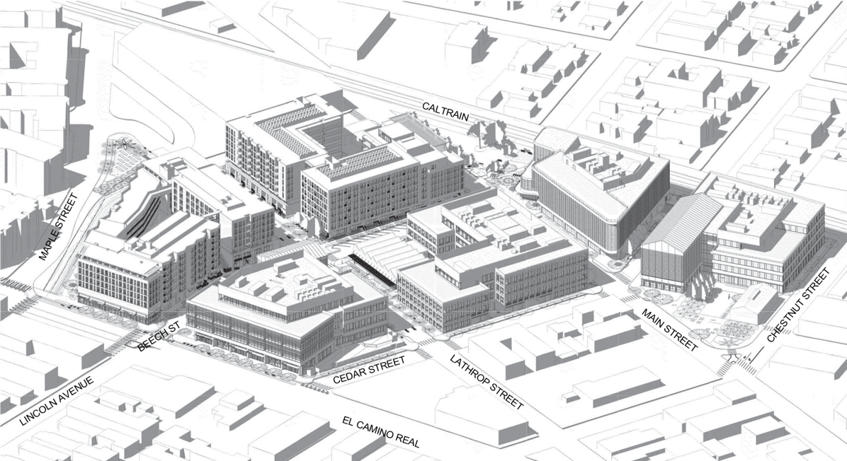
[As always, click on any of the images in this post to get a larger version you can zoom in on]
The buildings are a mix of residential and office space, with retail on the ground floor of a couple of them. Plans for the office buildings don’t show much detail in the office areas since the ultimate tenant(s) will determine how the space will be used and thus the interior layout. Other than elevators, stairs, restrooms, and outdoor areas, the most interesting part of the office buildings for me, from a plan perspective, is the garage. I particularly pay attention to where the vehicles enter and exit the garage, and how the cars are parked. For instance, here is a portion of the page showing the ground floor of building C, the somewhat L-shaped building (it isn’t, really) in the center of the overhead rendering, above.
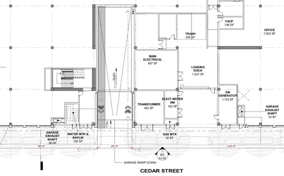
All of the white space to the left and right is where some of the offices will be. But the part I’m most interested in here is the garage entrance, which is off Cedar Street (this building’s main pedestrian entrance is off Main Street). Look for the “chevrons” marking the bike lanes; this is where cars (and bikes) will go into and out of the garage. This drawing shows that they will go from the street directly onto a ramp down to an underground garage. Later plan pages show that the garage is a two-level one. Here is a portion of the page showing the first level, “B1”:
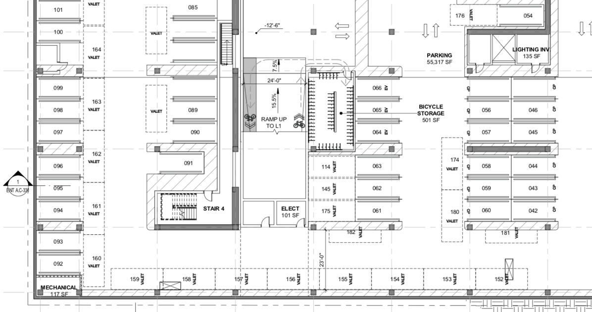
In the middle you can see where the ramp from ground level comes down. To the immediate right of that is a bicycle storage area. Most of the rest of the floor, as you might expect, is marked out for vehicle parking. But note that there are some dotted-line markings that block other spaces: zoom in and you’ll see the word “valet” on those dotted boxes. This of course indicates that in order to squeeze in the required number of cars, a valet service will need to be used.
Not included in this particular excerpt, but clearly marked elsewhere on the drawing, are a number of handicap parking spaces. As for the areas on the plan shaded with angled lines, those are pedestrian walkways and spaces to otherwise be left open.
Here is an interesting portion of the plan for the first basement level of building B, the one on El Camino Real between Beech and Cedar streets:

In this building, cars enter off Beech Street and immediately head down to this, the first parking level. But this particular building has a large retail space on the ground floor dedicated to “family entertainment” as well as a childcare center, with the upper floors being designated as offices. Thus, there is need for both public parking, for those going to the family entertainment center and the childcare center, and private parking for those working on the upper floors. This drawing shows that all of the parking on this first level is for public use. The ramp outlined in red leads down to two additional parking levels, levels which are exclusively for use of those working in the building. If you look carefully between the two arrows that are pointing towards each other at what is the top of the ramp, you can see that there is a gate mechanism that will prevent members of the public from descending to the lower levels. Also note that unlike in the previous parking garage drawing, the space numbers are prefixed with the letter “P”, indicating that these are public parking spaces.
I noted that you enter this building from Beech Street: that reminds me to point out another interesting feature of this project, which is illustrated pretty clearly on another plan page:

Today, Beech Street proceeds in a straight line between Lathrop Street and El Camino Real, as marked above in gray. Greystar, the project’s developer, plans to bend the street as shown by the heavy dashed lines so that Beech Street meets up cleanly with Lincoln Avenue.
This project also calls out for another change to some roadways, in order to assemble a single parcel for building E. This parcel is triangular in shape (if you count the Main Street Dog Park, which is not part of the project but forms the tip of the triangle), and is bounded by Main Street, Chestnut Street, and the Caltrain tracks:
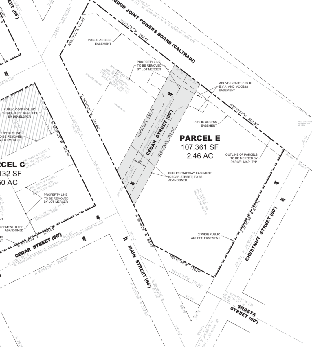
In the above it doesn’t look much like a triangle, but I’ll get to that in a second. First, focus in on Cedar Street, which dead-ends into the Caltrain tracks and currently only exists to provide access to the parcels on either side (one of which contains the Perry Feeds shed, and the other of which contains a self-serve car wash and the now-closed roller rink). The developer wants to “abandon” Cedar Street, which would transfer it from city ownership to the developer. The then-private street would be turned into what is essentially a private driveway leading to the entrance to the garage beneath.
It is probably here where I should point out that there are either one or two office buildings on this property, depending upon how you count: the developer refers to them as “E-N” and “E-S”, or E-North and E-South. However, they both sit on a single large two-level underground parking garage, so you could also think of the structure as a single building with two above-ground protrusions. Either way, the two office buildings would share the triangular parcel with an open plaza that would include the Perry Feeds shed — sort-of. The developer actually plans to demolish the tin shed and build a reproduction of it, one that would contain a new restaurant run by the Main & Elm folks (Main & Elm would itself close if and when this project gets underway, incidentally). That plaza, along with the new version of the shed, is shown in the following:
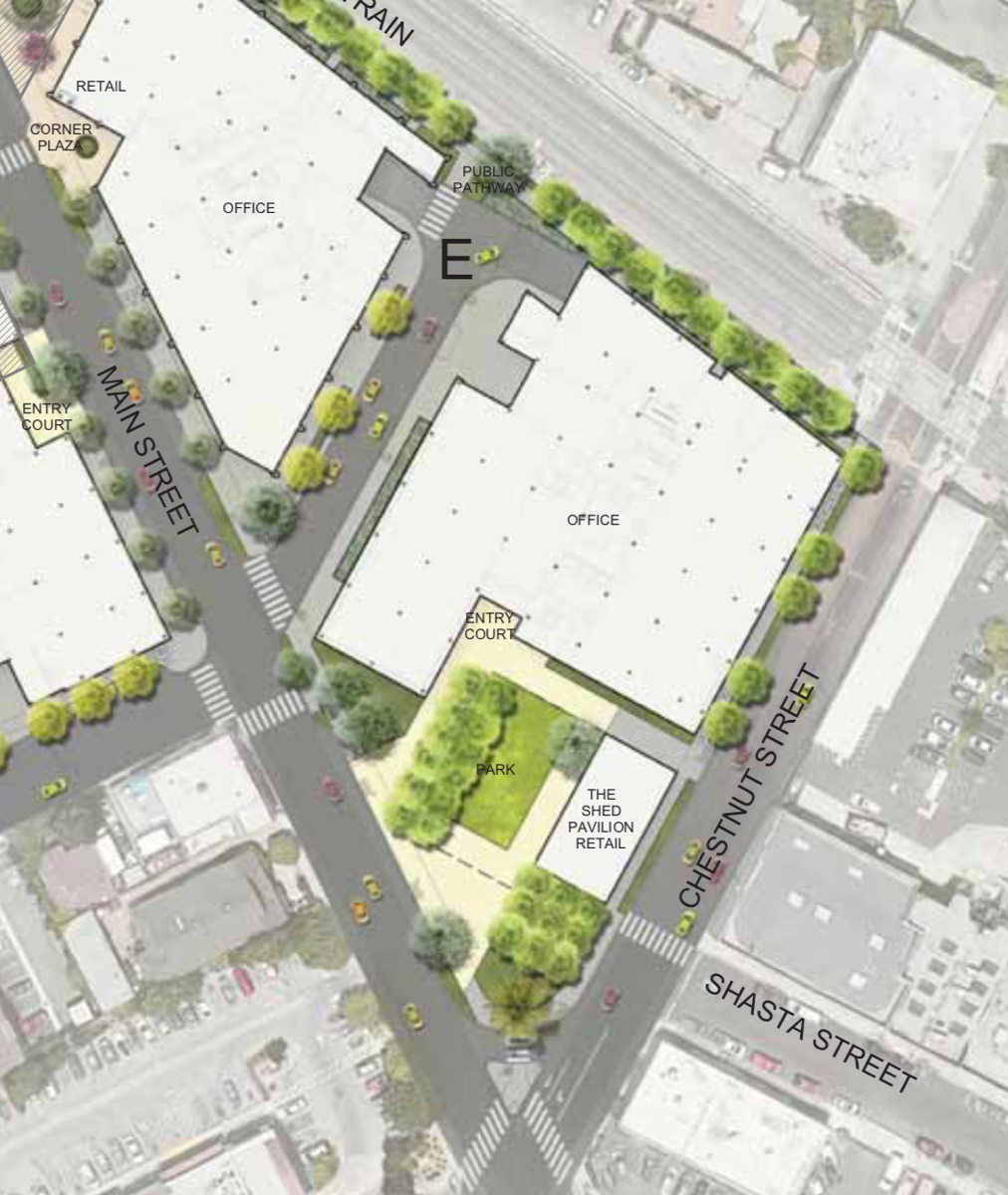
While your eye is probably drawn to the greenery and the open plaza that we, the public, will be able to enjoy, be sure to note the change to the lot configuration. By comparing the above image to the one before that showed the streets around this parcel, you can see that the intent is to abandon the short bit of Shasta Street that connected to Main Street and add it to the plaza. This transforms what today is a messy, confusing intersection with a tiny triangular parklet in the middle into a useful public space. And, of course, it turns the block into a neat triangle (again, if you include the dog park, which is just beyond the upper left corner of the image).
Later in the plans there is a set of drawings and renderings for the so-called “building F,” which is the one located off-site at 1304 El Camino Real. This would be a 39-unit apartment building that would contain 38 affordable units (30 studios and 8 one-bedroom units) plus a two-bedroom manager’s unit. The lot itself is pretty small, so the building would be constructed to extend almost exactly to the lot lines, with no ground-floor yard space: the plans show an outdoor common area on the rooftop. To keep costs down the garage would be above-ground, and would use mechanical stackers to fit in the required minimum number of cars:
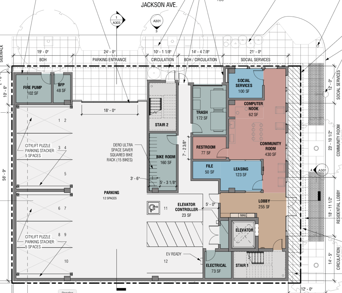
The spaces are numbered (with the stackers squeezing ten cars into the space normally needed for six); with the one van-accessible space and the EV-ready space, there are twelve automobile parking spaces (and 15 spaces for long-term bicycle parking) within this garage. Twelve spaces for 39 apartments may not sound like a lot, but I gather that the assumption is that many of the low-income tenants won’t own a car. This becomes more plausible when you consider that this building is within easy walking distance of not only our Caltrain station, but a great deal of shopping as well — and that the building sits on El Camino Real and thus has easy access to our bus system.
The plans for this building don’t show apartment layouts, but they do show that there is a laundry room on each residential floor. Although the apartment layouts aren’t shown, a while back I noted that the one-story building currently on this site was being used for staging of materials for the building that Greystar was constructing at 1409 El Camino Real. Peeking in the windows to see what they might be storing in the former Precision Tune Auto Care, I saw this:
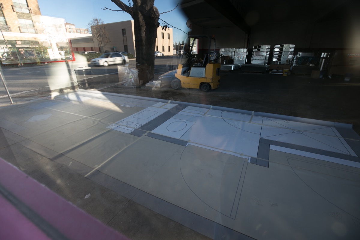
(Sorry for the glare and the reflections; the glass was dirty and the lighting was challenging.) It appears that Greystar had mocked up a life-sized floor plan for a very efficient studio apartment. Although the shape of this apartment doesn’t appear to match up with the shape of the ones that they hope to build on this site, from this image you can get a pretty good idea of how they hope to keep costs down for a low-income studio apartment.
The curved lines show the sweep of the unit’s doors: the one all the way in the lower-right corner shows the entrance door to the apartment. The “large” area in white is the unit’s bathroom: it consists of a shower (the square area marked with an “X”), a sink, and a toilet. To the left of the bathroom, on the other side of the interior wall marked in grey, is the unit’s tiny kitchen. This appears to have a two-burner cooktop, a sink, and what I’m guessing is an under-counter fridge. I don’t know if this unit would have a regular oven, or would simply get by with a microwave.
To the left of the single-counter kitchen is the unit’s living/sleeping area. Here’s a second photo that shows that portion a bit more clearly:
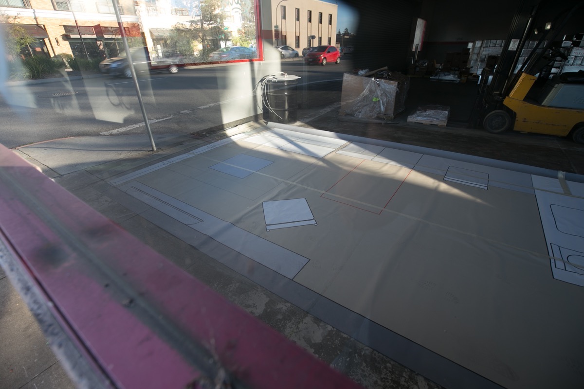
You may want to zoom in on this one, but as I read it, starting at the kitchen (which is of course at the very right edge of the photo) and working counterclockwise we have a counter along the wall with a chair pulled up underneath, which presumably could be used either as a dining space for a single person or a work desk. Next, there is either more counter or some cabinets (this may be the unit’s “closet”). The red rectangle on the floor here may indicate a Murphy bed; either that, or the small two-person couch, which is located in the far corner, pulls out into a bed. Along the short left wall are the unit’s windows. Then, that narrow thing along the near wall starting in the corner appears to be a narrow cabinet with space for a television. Finally, there is a small table or ottoman in front of the couch, and a chair, sitting at an angle, near the center of the space.
As you can see, this is a tight space, but it has all of the basics. With laundry equipment just down the hall, and a rooftop space where one can sit outdoors with some degree of privacy, what more does one really need? Whether or not Greystar plans to build any units with just this configuration, I do like how they’re trying to bring costs down in order to make low-income units increasingly feasible.
Plans, whether they are on a page or on the floor, are useful things that are full of interesting details. I enjoy imagining myself living, working, or simply existing in the spaces that they represent, and get a kick out of seeing new ways that buildings can be configured for efficiency. Even if you don’t like drawing them, I highly recommend spending time learning to read plans. They are a great way to gain an in-depth understanding of what our property developers are hoping to bring to our ever-growing city.
As I’m sure everyone is well aware, we have an election coming up in November. Beyond the national and state-wide candidates and issues, we will be voting on new City Council members. Starting Monday, July 13, the city will be accepting nominations for candidates. If you are interested or know of someone who might be — and if you or that person live in one of Redwood City’s new voting districts with an open seat (Districts 1, 3, 4, and 7; see the map here) — now’s the time! For more information and some directions on how to get started, see the city’s news release on the subject.
If becoming a City Council member is not your thing, or if you don’t live in one of the districts with an open seat but still want to have more of a say in how the city operates, the city also has a number of open seats on its various boards, commissions and committees. Head over to the city’s website, here, to see a list of open seats and to find a link to where you apply.

I like that the Main & Elm restaurant is being preserved and relocated to the new Shed plaza, and I like how the Shasta St triangle is being removed and incorporated into the plaza.
I also like how Beech St is realigned between ECR and Lathrop, and looks more like a regular street now between ECR and Main. I referenced your Feb 9, 2018 post “On The Beech” for differences between the original plan and the current one. Beech St was originally a pedestrian-focused lane with no street parking. I also see Lathrop park gone, at the corner of building C. Its public green space was likely replaced by the Shed plaza.
Do you know where Towne Ford and Hopkins Acura will relocate? Will they move to Boardwalk row, which seems already congested, and may soon lose the parking lot of the shuttered Century theatre? The city could lose out on their sales tax receipts if they leave town.
Overall, I like this plan but I wish building B were residential instead of office space. Thus, all the buildings fronting ECR (A, B, F) are residential, and all buildings along Main St (C, D, E) are office.
Chestnut Street from El Camino to Middlefield and beyond has been my most frequent route through RWC since we moved to Vera Avenue 20 years ago. I always look at the Perry Feed Shed, and have wished I’d stopped and taken photos of it before the well-meaning but fiddly bit of landscaping was done a while back around the big palm tree there. It speaks to me of California as I saw it growing up (from South Pasadena in the late ’40s, to trips up and down the state and beyond ever since). Can’t quite say why, but it has a simplicity and endurance I like. Will hope that the “reproduction” includes tin siding….
Thanks as always for your weekly report!
— Jennifer H.
Hi Greg, Remember the house at Turnsworth cor. Whipple that decorates all those skeletons during Halloween? The owners have sold the house but they moved to 200 block of Iris St. where they will continue their Halloween tradition. They said their new place has a much smaller front yard but they will make it work.
Jeniffer
Sent from my iPad
>
Oh, thanks for letting me know! I’ll keep an eye on Iris St come fall. Fortunately, they are still within walking distance of my house… 😀