
As a big science fiction fan, I knew the line, but thought it was from the movie. “My God — it’s full of stars” is a famous (in science fiction circles) line from, not the film 2001, but the novelization of that film that Arthur C. Clarke wrote alongside the screenplay (which he also wrote, in conjunction with the film’s director, Stanley Kubrick). Nevertheless, that is the phrase that popped into my head when I saw the Carnamic dealership this week. For several weeks this new dealership sat empty, with only the “Carnamic” signs to make us wonder. Then, a couple of dozen cars appears on the dealership’s smaller lot, at the very visible corner of Whipple Avenue and El Camino Real. But by this week both of the dealership’s lots were completely full:

Although I did notice some lights on in the main office, I didn’t see any salesmen around. Thus, either I didn’t do anything worthy of their attention — I didn’t step off the public sidewalk — or they aren’t yet ready to open their doors for business. But Carnamic certainly has plenty of cars to sell. I think that all of them are used, but a couple looked as if they might be new (as I’ve written before, the owner of this dealership has several new car dealerships in other parts of the Bay Area). Likely they are all used, but at least they appear to be only lightly used. As well, they appear for the most part to be high-end cars. I saw a Mini in there, but most of what I saw were cars from Mercedes, BMW, Lexus, Infiniti, and even Maserati (plus that large Ford F-150 in the foreground of the above picture!). I’m wondering if Carnamic’s owner is moving the best of the used cars from his other dealerships to this location, to make it a one-stop-shop for a high-quality, high-end used car. I’ll continue to walk by, and when I do actually see signs of human life I’ll stop in and see what I can learn about their business model and the name “Carnamic.” And I’ll let you know…
Last week I took a walk out to the other side of Highway 101, both to check on the U.S. Highway 101 Pedestrian Undercrossing Project as well as on the Strada – 1548 Maple Street project. Because I got there first, allow me to talk about the undercrossing project first.
When heading to the other side of Highway 101 I usually walk up Maple Street, which although not an ideal route, for a long time has been the safest route when crossing the freeway on foot. As I’ve noted on more than one occasion, although there are proper sidewalks and marked crosswalks if you cross the freeway at Whipple Avenue, the cars pretty much ignore the crosswalks at the on- and off-ramps. Particularly at the on-ramps, especially during hours when the freeway metering signals are off the cars are already getting up a head of steam as they approach the ramp, meaning that they are moving quickly and the drivers are focused on navigating the on-ramp’s curve. What they are not doing is looking for pedestrians trying to cross that ramp. So it can be a tricky business, and thus I avoid Whipple Avenue whenever possible.
Maple is much better since it crosses the freeway but has no direct access to it: there are no on- or off-ramps to contend with. But leading up to the freeway Maple Street has no sidewalks on either side of the road, so you find yourself either walking on the dirt shoulder, or walking on the very edge of the roadbed. Then, when crossing the freeway itself there is only a very narrow cement walkway on the south side, with a railing between you and the freeway below, one that is probably lower than is really safe. So when crossing the freeway here, you have to really pay attention to both your surroundings and to what you are doing. On the plus side, at least during the hours when I’m typically making the crossing (in the middle of the day on a weekday), Maple Street sees relatively little vehicular traffic.
The third way to get across Highway 101 is a path I’ve only taken a couple of times. This is the dirt path beneath Highway 101 that runs alongside Redwood Creek. The path starts where Main Street turns into the Kohl’s Plaza parking lot (by the old Toys ‘R Us, which today is a Sports Basement) and ends on the other side. Technically you can follow either bank of the creek, but most people seem to use the southeast side, which ends up over by Docktown Marina. From there you can use the “bridge to nowhere” to cross the creek; this brings you to where the path along the northwest side of the creek comes in.
Allow me to show you what I’m talking about, with a little help from Google Earth:
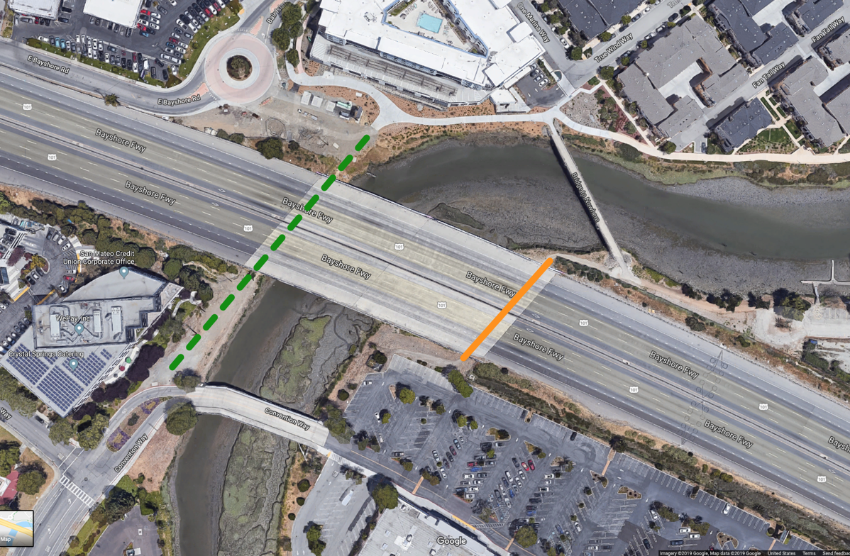
I’ve augmented the above image with two lines. The first is a solid orange line. This is the path that most people take (beneath the freeway, of course!). As you can see, it starts in the shopping plaza parking lot, and ends up meeting a dirt path that either follows the freeway towards the south, which takes you to Docktown and to the site of the 1548 Maple Street project (which I’ll update you on in a minute), or you can take that thin bridge to the north that deposits you by the One Marina condominiums and the Courtyard by Marriott hotel.
People tend to take this path because there is more headroom under Highway 101 on this side — although still not a great deal — and because, as you can probably see, the creek bank on this side is significantly wider, making for a more comfortable walk. There are a lot of pilings holding up the freeway under there, and the path can be quite muddy at times, but especially now it is not a bad way to go:
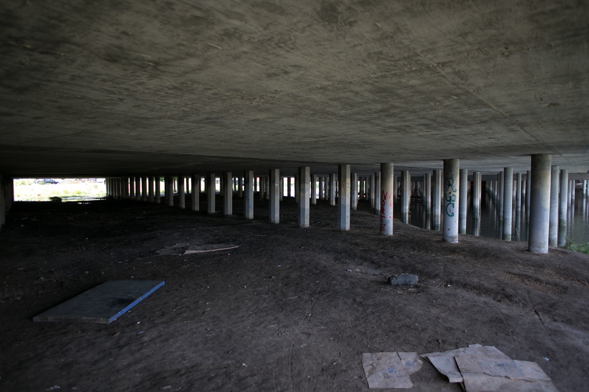
(This picture is looking back at the shopping plaza parking lot from the Docktown side of the path.) The reason I say “especially now” when I note that it is not a bad way to go is because just a couple of weeks ago this same picture would have shown a fairly good-sized homeless encampment, plus a lot of junk. But the city has recently gone through and cleaned out this area, and given the postings I saw on one or two of the pilings I suspect that they intend to keep it free of lodgers.
I mentioned that there is a path on the other side of the creek — in the Google Earth photo I marked where that path goes with a green dashed line — and there is, although I’ve never used it. For one reason, at times someone was living on that side as well, and there was very little room to get around their “home.” For another, there is less headroom, meaning that I’d have to bend over to navigate some or all of the crossing.
That other side, though, has one major plus: it connects more directly to where almost all of the Bair Island neighborhood’s residents live. And on the downtown side, it can easily connect to the sidewalk that runs along Main Street. For these reasons, it is the side where the U.S. Highway 101 Pedestrian Undercrossing will go.
This project has been long in the planning stages, but it finally reached a major milestone when the utilities that ran along this side of the creek were relocated to make way for the new undercrossing. Then, in mid-April, construction fencing went up on both sides of the project.
Here is the fenced-off area on the downtown side of the project, showing where the path will run (note today’s lack of headroom under the freeway!):
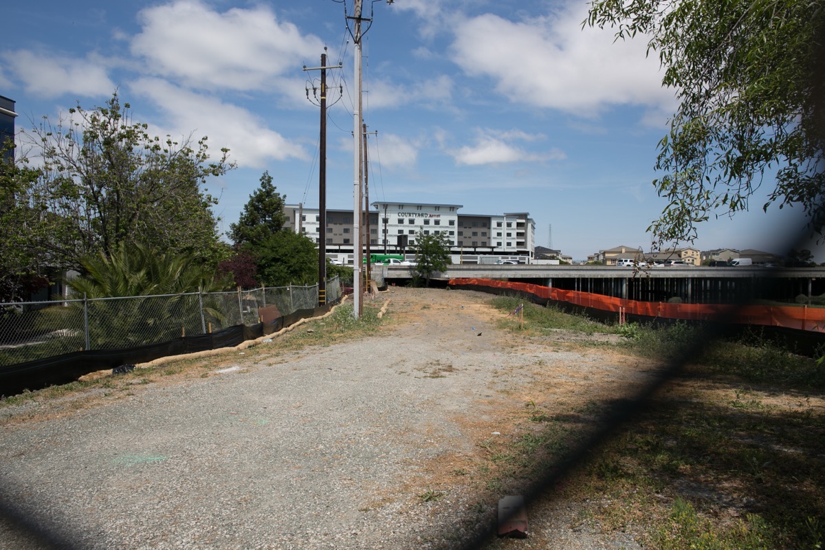
And here is a view of the project from the other side of the freeway:

The fenced-off area is significantly larger on this side; there is more open land here, and easy vehicular access from the adjacent roundabout that sits between the Boardwalk Auto dealership and the Courtyard by Marriott Hotel (you can clearly see the roundabout, and the open land, in the Google Earth photo I shared earlier). Thus, this is where materials and equipment will be stored during construction.
As an aside, that fat pipe that you can see running along side of the freeway in the above picture? That is one of the famous “purple pipes” that carries reclaimed water from the water reclamation plant in Redwood Shores to Redwood City’s downtown, where it is used in some places for irrigation, and for toilet flushing in some of the newer buildings.
As of today (Friday, May 17) the previous two photos show the current state of the project. The site has been prepped, but actual construction on the undercrossing has yet to begin. I expect it to start very soon, however.
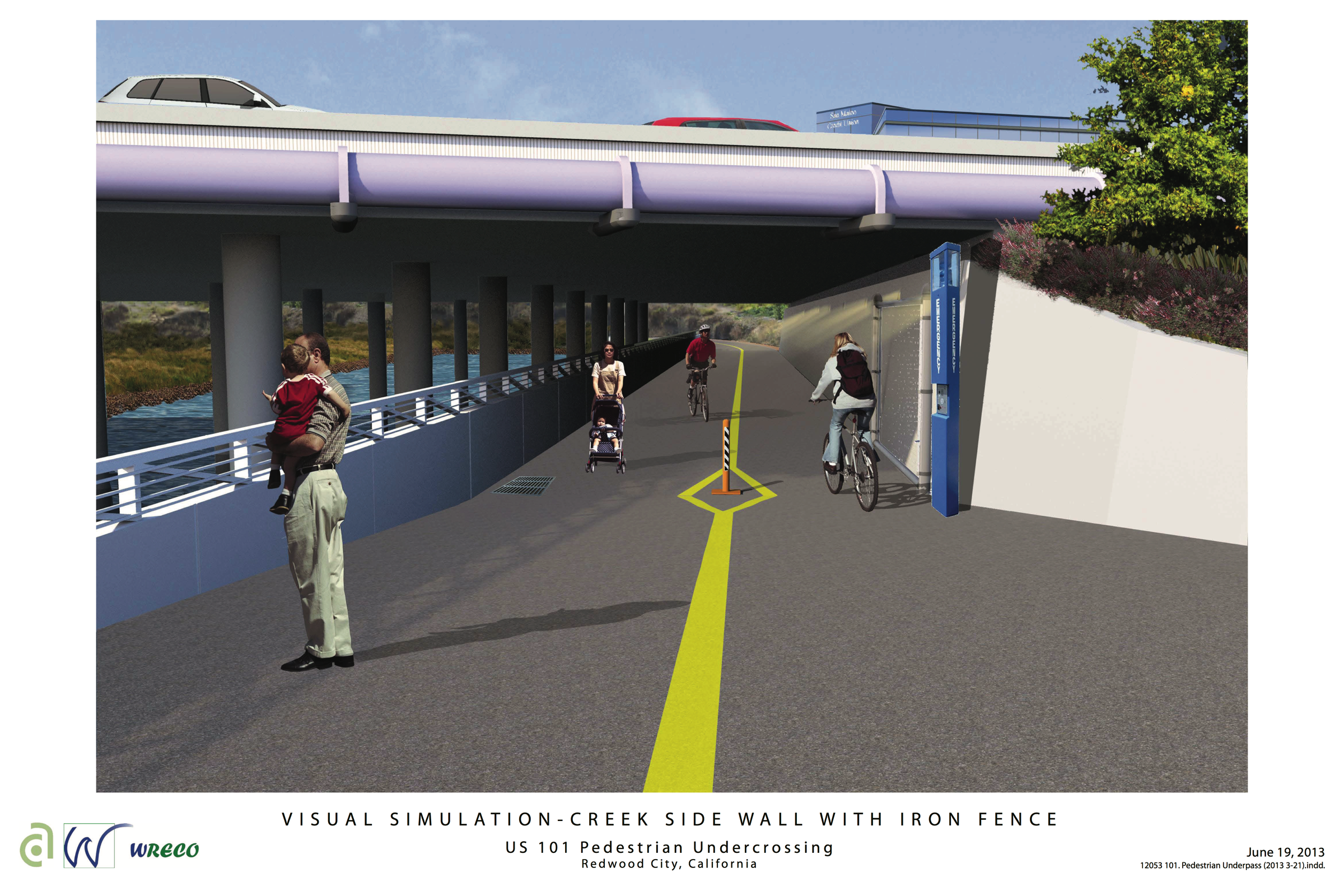
As for what is being built, it will be a 700-foot-long, 14-foot-wide (12 feet wide once it emerges from under the freeway) path. Under the freeway the path will be dug to a comfortable depth (9 to 10 feet), enabling pedestrians and cyclists to navigate it without having to duck. On the side of the path away from the creek there will be a wall to keep the soil back. On the creek side there will be a shorter wall with a railing on top that will protect users of the path from the creek itself, while not blocking the view.
Approaching the undercrossing the sidewalk will be lined with trees and pedestrian lighting. On each side of the undercrossing there will be security access gates and emergency call boxes. Those gates will be closed by the city when conditions are deemed to be unsafe, such as when the creek levels are especially high.
I’m very excited for this project to finish up. I for one will be making good use of it! In the meantime, though, I’m hopeful that the city will continue to keep the informal path on the other side of the creek clear, since it is a much more direct route than using Maple Street.
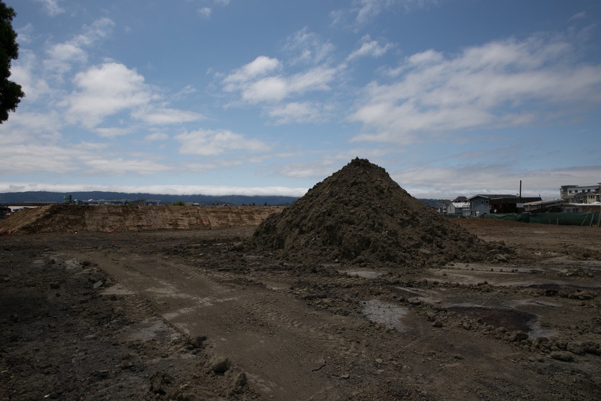
Making that walk beneath the freeway leads one to a very interesting part of the city. For years it dropped you off at Docktown, which was a quiet, but quite interesting, community of floating homes along the creek. The path still does, although as you probably know Docktown today is a shadow of its former self — and depending upon the outcome of a couple of lawsuits, may soon cease to exist altogether. On a more positive note, however, the project approved for the privately owned land immediately adjacent to the creek in this area is well underway now. Thus, taking this path is a good way to check on the status of the “Strada” project at 1548 Maple St.
As of about ten days ago, when I took the above pictures, most of the pavement that once occupied the site — it had been used for parking for the Docktown Marina, as well as for storage of excess inventory by some of Redwood City’s automobile dealerships — had been ripped up, and work to raise the level of the land was well underway. For instance, note the large flat-topped mound behind the conical pile of dirt in the foreground of this image:
I dropped by again today just to see what had transpired over the last week and a half, and noted that work has shifted to the other end of the triangular property, close to the entrance to Docktown Marina off Maple Street. Today the workers were demolishing one of the last remaining buildings on the property, what I believe was the old Harbor Master’s office:
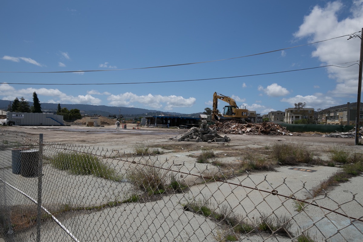
The only building that still remains on the property can be seen in the above picture to the left of the large backhoe: that is the old Yacht Club clubhouse. The “historic water tank” (which may have been an oil tank) used to sit above this building, but that has since been removed. I presume that when the backhoe is done with the pile of building scraps it was working with, it will then turn its focus on that Yacht Club building, which will be meeting the same fate. After that, expect the concrete you see in the foreground to be ripped up and disposed of.
For now, then, it is all about demolition on that side of the freeway. As for what they will be building, I’ve written about that before, so if you don’t already know, might I suggest that you check out my post On the Waterfront, from last December?
Just to bring things full circle, I took the above picture from Maple Street. Directly behind me as I did so was a large lot that was, as you might guess, full of cars. Towne Ford uses this lot — and a great deal of parking along this part of Maple Street, in fact — to store much of their inventory of commercial vehicles. Thus, the street and the lot are full of trucks, and vans, of a wide variety of configurations. That particular piece of land is owned by the city of Redwood City, and may someday become a public park. But not for quite some time, I’m guessing…

I did a similar walk at about the same time, and snapped the following photos of the underpass construction work, Docktown @ low tide, where the old (riddled with rust and holes in the roof) PYC “water” tank is hiding & the Rolled Up Creamery during its soft opening: https://photos.app.goo.gl/h2ajysUvDGwVoDav5