
The other day, as I was sitting down to my computer, I received a text from my wife, who had left the house not long before. It seems that her car radio had been tuned to KQED FM, and a segment of the Forum radio show had come on regarding the Redwood City Saltworks project. Knowing that the Saltworks is a subject that is near and dear to my heart, she urged me to turn on the radio. I did, and caught the last part of the 22-minute segment. Fortunately, shortly thereafter KQED posted audio of the entire segment to the Internet, along with a companion article on their website, so I was able to listen to the whole thing.
I’m interested in the Saltworks for a couple of reasons. One, it has been a long-standing part of Redwood City’s history. And two, for about three years I had the extreme good fortune to work for a company called NeXT out at Seaport Centre, and our building was located right next to the giant salt pile. Thus I was able to watch the operation in person: a process I found endlessly fascinating.
In researching the history of salt harvesting here in Redwood City, I was surprised to see that there appear to be multiple conflicting stories about exactly what happened when. However, we do know that early Native Americans used diked ponds to evaporate bay water so they could obtain the salt that was left behind. And as far as commercial harvesting goes, it seems safe to say that salt harvesting here in Redwood City began in the early 1900’s (possibly as early as 1901). By the 1920’s, the Leslie Salt Co., which had its beginnings up in San Mateo, was harvesting salt from some 40,000 acres of salt ponds in our area: salt ponds created out of former wetlands through the judicious construction of dikes. In 1978 Cargill bought Leslie Salt. Cargill continued to harvest salt in Redwood City until around 2006, when for various reasons they ceased operations here and shifted their focus to their Newark facility.
Cargill’s Newark plant has one thing we didn’t: a refinery. The refinery allows the harvested salt to be refined into a product that can be consumed by humans: table salt and salt that can be used in food and medicines. The salt that was produced in Redwood City was unprocessed industrial salt which was only appropriate for road de-icing and industrial uses. The lack of a refinery is one of the reasons Cargill cited when shuttering their operations here in Redwood City.
Just how did the process work? It was amazingly low-tech, and remarkably similar to what the Native Americans did way back when. Leslie/Cargill did it on a scale that those early Americans could never have imagined, however. When our ponds were still in use, the process began by letting bay water into shallow ponds on the Newark side of the bay, where it was allowed to partially evaporate. It was then moved to another set of nearby ponds and allowed to evaporate further. This process was repeated until a specified high degree of salinity was reached. The brine was then pumped through a trans-bay pipeline to ponds here in Redwood City, where it was further evaporated, to the point where the salt crystals precipitated out and sank to the bottom. The remaining liquid was then moved to another pond, exposing the crystalized salt. Then, the salt was scraped up and put into a set of ore cars attached to a small locomotive.
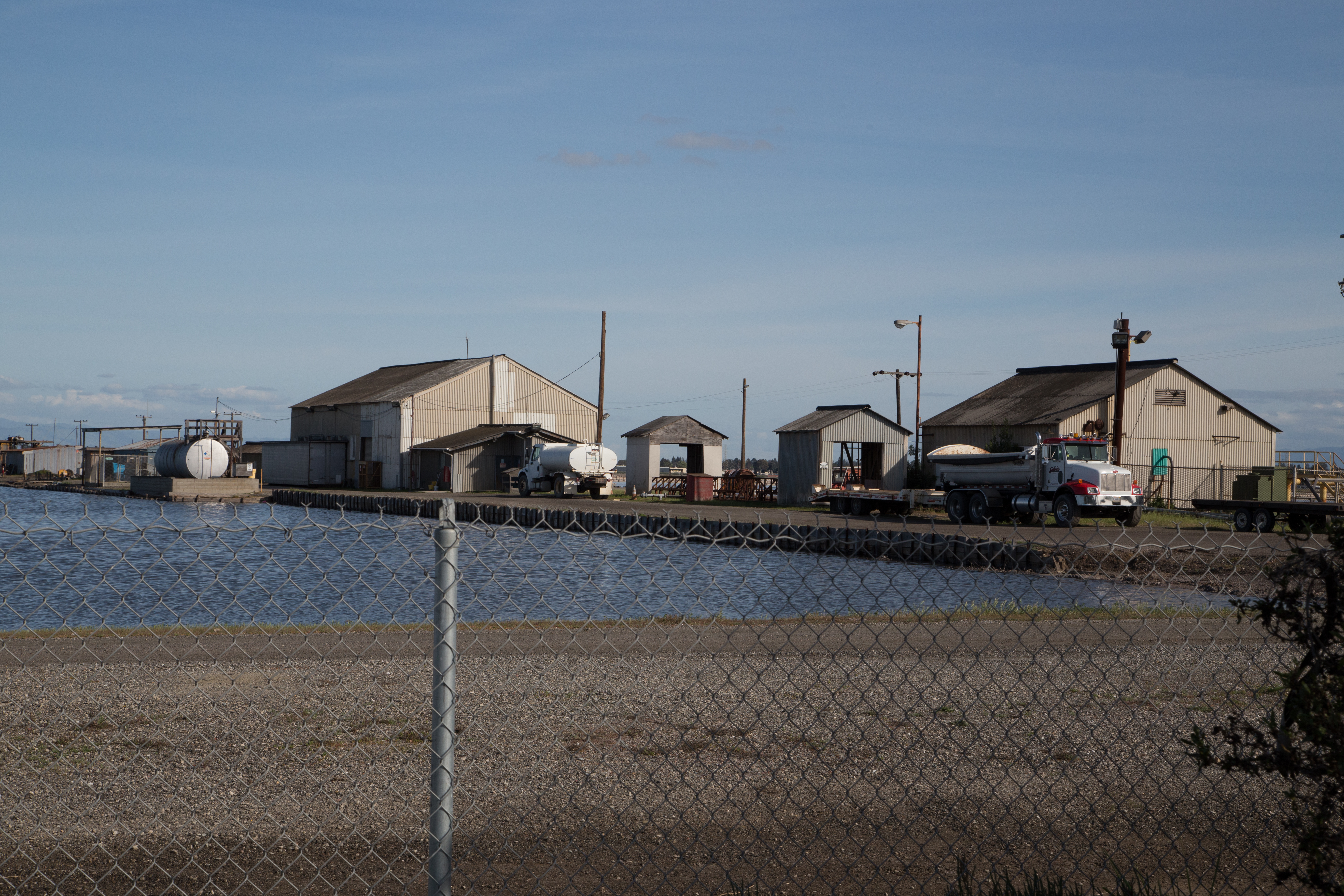
Back when I worked in the area, I used to take lunchtime walks and observe the harvesting. I would look out across Seaport Blvd. and watch the salt harvester working the dry ponds, scraping the salt and piling it into the train cars. When each of the train cars had been piled high with salt, the train—which ran on a set of tracks that ringed the ponds—would haul the salt to a metal shed, where the salt apparently was washed. Although the train and much of the salt-making equipment has been removed, as I learned on a recent walk the sheds still remain on the southeast side of Seaport Blvd., just beyond Chesapeake Drive:
Once washed, the salt was deposited on a series of conveyor belts that begain at the washing shed. The conveyor was a long one: starting from the shed it dropped down and passed underneath Seaport Blvd. It then ran under a long wooden walkway that went right by the building in which I worked (the building on the left in the following photo):
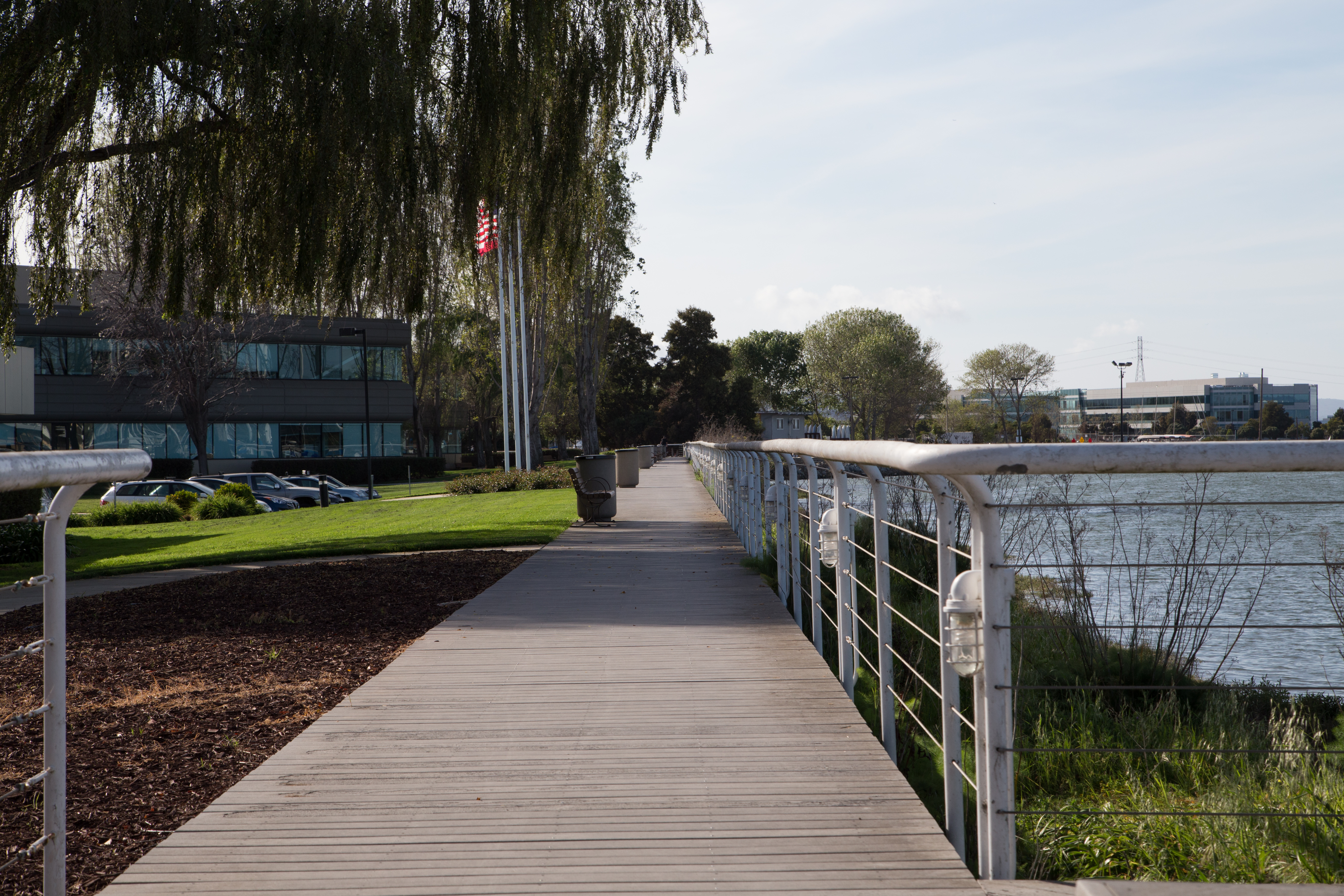
I used to go out on the walkway when the belt was in use. You could feel the vibration from the conveyor mechanism. Down past the flagpoles in the above picture the walkway ends (pedestrians step down to a concrete sidewalk) but the conveyor continues on and bends to the right. The following photo shows this bend from the other direction, looking back towards the boardwalk and, beyond the trees in the distance, the salt harvesting ponds:

From here it was pretty much a straight shot to Cargill’s property along Redwood Creek, where the conveyor finally emerged from below ground. There the salt was then carried up a long incline from which it fell to the top of an enormous salt pile. This pile once stood near the operation’s private wharf (the salt pile and all of the equipment here has been removed; only the wharf remains):

For a couple of months, between when NeXT was sold to Apple and when I and my team were transferred to Cupertino, I had an office that looked directly out at the salt pile. I used to watch a tractor driving back and forth on the pile itself. When there was a ship tied up at the wharf, the tractor would push the salt onto another conveyor that transferred it to the waiting ship. When no ship was in port, it simply reshaped the pile, spreading the salt and making room for more to be dropped from above. It must have been an incredibly monotonous job: I always wondered about the guy who did it, and what kind of dark glasses he must be wearing to protect him from the glare reflecting off the blinding white pile.
Now that the pile is gone, I wish I had taken pictures of the operation back when I was working in the area. The Schilling Family website has some pictures of the harvesting process, however, and http://www.rcsaltworks.com has a few that you can scroll through showing Redwood City’s operation in particular.
Cargill ceased operations here in Redwood City on or around 2006. Since then they have removed much of the equipment used in the process. In particular, the train and the tracks upon which it ran have been taken out. The salt ponds themselves remain, though. Earlier this week, those ponds were full of water:

From ground level it’s hard to get an idea of the scale of the property. Fortunately we have aerial views, thanks to Google Earth:

101 runs across the bottom of this photo. The large intersection near the lower-left corner is the Woodside/101 interchange (Woodside becomes Seaport Blvd. as it crosses under 101), and the interchange near the lower right is where Marsh Rd. meets 101. The Saltworks property in total is about 1,430 acres, or about 2.2 square miles; about the size of San Francisco’s Presidio. For reference, all of Redwood City is about 19.5 square miles in area (it isn’t clear whether or not this figure includes the Saltworks property).
Around the time that Cargill shut down the salt harvesting operation, they teamed up with DMB Associates, an Arizona-based real estate developer (the part of the company based in our area has since split off into a separate, San Francisco-based company named DMB Pacific Ventures; they are the ones who are partnered with Cargill on the proposed project). Together, they formed Redwood City Saltworks and came up with the idea to build homes on the former salt ponds. Ever since then they have been refining their plans and trying to drum up support for the massive project.
In 2009 DMB Pacific Ventures introduced something they titled the “50/50 Balanced Plan” which proposed a mix of housing, retail, and open space on the site. Half, or 50%, of the land was supposed to be permanent open space, public recreation areas (sports fields and the like), and tidal marsh restoration. The remainder would be housing, schools, parks, retail, and transit facilities.
The plan called for up to one million square feet of office space and between 8,000 and 12,000 housing units—which could mean adding as many as 25,000 people to Redwood City’s population (as of 2013 our population was about 81,000).
The plan went both to the federal government and to Redwood City’s City Council for review. For the year or two it was under local review a great deal of the City Council’s and their staff’s time was taken up with the effort. As it was being reviewed, public sentiment, which originally seemed to favor the plan, started shifting towards the opposition. Finally, in 2012, a subcomittee of the City Council (consisting of Jeff Ira and Barbara Pierce) recommended that rather than ask the community for an advisory vote on the project, the City Council should simply deny the project application outright. That recommendation was all it took: mere hours after it was issued the developers withdrew their project application. While they retain the ability to submit a new application at any time, this freed our City Council from having to spend any more time on the project. And it kept the project from officially being turned down by the City Council.
As for the federal government, both the US Army Corps of Engineers and the Environmental Protection Agency (the EPA) were asked to consider, among other things, whether or not the project area is governed by the Clean Water Act. After considering the issue, the US Army Corps had apparently decided that no, the Clean Water Act doesn’t apply in this case. But just before they made the official announcement, the EPA—who had been virtually silent on the issue until that point—stepped in, announcing that they would be making the decision. The EPA is now considering the issue, and should be making their ruling known in late 2015 or early 2016.
The EPA’s decision, when they make it, may not be all or nothing: they may in fact decide that part of the project area can be developed, and part of it cannot. But if that is their decision, by reducing the scope of the project it may become financially infeasable, effectively killing the project. Because the EPA stepped in the way it did, it may well have some disagreement with the Army Corps’ decision, and thus some suspect that it will rule against development on all or part of the property.
The developers, naturally, are furious with the lack of a decision in their favor and with the delay this adds, even if the EPA’s final ruling does allow the project to proceed. Of course, this one decision isn’t the only thing that could stop the project: there are numerous other hurdles to be overcome, not least of which is the fact that the site is currently zoned “tidal plain”; Redwood City’s planning commission would need to provide an exemption in order for any development to take place. There is also the issue of resources (where do you get the water and power for that many new homes, and can our sanitary systems handle the additional load?) and the traffic problems that so many additional vehicles will bring. Also, there is the issue of sea level rise: how do you protect those properties if seas rise ten, fifteen, or even thirty feet from today’s levels? The site would need levees to protect it from flooding, both from storms in the short term and rising sea levels in the long term.
David Lewis, Executive Director of Save the Bay, was one of the guests on the Forum radio show I mentioned at the outset. As you might expect, he thinks this project should be killed, and that the lands should be restored to wetlands, as is being done with our own Bair Island. While there are issues with this as well—primarily, coming up with the money to do the restoration—wetlands could go a long way towards protecting the rest of Redwood City from sea level rise. Recent flooding like that experienced by the mobile home parks on the bay side of 101 could be ameliorated by having wetlands act as a buffer between our city and the bay. As well, wetlands would help to filter the storm runoff that we currently send out into the bay (on the increasingly rare days when it rains, that is), resulting in a cleaner, less-polluted bay. And, of course, wetlands would not only serve as much-needed wildlife habitat, but would also provide additional open space for hikers and bird watchers. Finally, research shows that restoring the site to tidal marshes could cut carbon emissions: wetlands consume more carbon dioxide than most forests, according to Stephen Crooks, a scientist at Philip Williams & Associates in San Francisco who has studied the effects of wetlands on climate change.
Cargill, who owns the property, doesn’t even consider full restoration to tidal wetlands to be a possibility. In their view, the only options are either develop the property or continue to use it for salt production. Which is odd, considering that in 2002 Cargill sold some 16,500 acres of their commercial salt ponds throughout the bay to state and federal governments to be restored to tidal wetlands. 7,000 of those acres were right here in Redwood City; lands that were folded into the Don Edwards San Francisco Bay National Wildlife Refuge.
When they originally presented the project, DMB Pacific Ventures noted the real need for additional housing in the area. While that was (and still is) true, a number of large housing developments have since been built (or are being built). As well, the thinking about where new housing should be seems to have shifted, from peripheral areas such as the Saltworks property to “infill” projects clustered around transit. Walkability is key these days, greatly reducing the need for cars. Even with all the new development going on these days, we won’t see 12,000 new housing units downtown, of course, but the need isn’t limited to Redwood City: other cities around the Bay Area should build similar infill housing. Together, we can easily build 12,000 units—or even more.
While I am not in favor of the Saltworks project, I think that the final opinion expressed by Save the Bay’s Executive Director on KQED’s Forum program,—that the project is now dead—is a tad premature. Me, I plan to wait for the EPA’s final decision. And I’ll keep walking in the area, admiring the beauty of a place that Cargill has labeled an industrial site.

Great posts. Lots of good info. Still not 100% sure how I feel about saltworks. If something of that scale gets approved a serious amount of infrastructural restructuring is in order. More than just wider roads. Having lived in Phoenix for a period of time I’ve been to a couple of DMB’s projects, specifically Verado and DC ranch/silver leaf. As far as suburban sprawl land developments go they did a nice job. Something that I can’t say about most of phoenix.