
Whether or not you believe Redwood City’s motto (“Climate Best by Government Test”), the weather here is excellent, and rarely interferes with a good walk. Back when I was commuting, I took advantage of the fact that Caltrain was only a mile from my house: for a good part of twenty years I began each workday with a brisk walk to the Redwood City station. Rain or shine, I was out there pounding the pavement. Other than adding a long raincoat and umbrella to my ensemble, with few exceptions rainy days didn’t affect my commute one whit. Yes, once or twice a year, if the rain was pounding down particularly hard, I would have my wife run me to the station in her car, but those days were few and far between.
People used to ask me why I persisted in commuting by train when it was storming out. Wouldn’t I be more comfortable, and wouldn’t I stay a lot drier, if I instead drove to work? I cannot deny that my car was more comfortable than a crowded Caltrain carriage, and my only exposure to the rain would have been the short dash from my front door to my garage and the slightly longer one from the parking lot to the office door. But rainy days are some of the last days I want to be out on the highways: Bay Area residents seem to have trouble driving in the rain, and I felt much, much safer on the train. As long as I took care to avoid puddles—both those I might step in as well as those that a passing car might drench me with—my raincoat and umbrella were more than enough to keep me clean and dry.
Walking because it was part part of my daily commute was one thing. The walks around Redwood City that I do these days, however, are something altogether different. While I still have my trusty raincoat and umbrella, I don’t need to be out every day, so I generally avoid going on a walk when it is raining. During the rainy season in particular I pay close attention to the forecast and schedule my walks between storms. I especially shoot for the gaps between back-to-back storms, never trusting the long-term forecast and having to risk being cooped up for several days in a row.
After one recent storm I was particularly eager to get some real exercise, so I headed up into the Emerald Hills area. My first stop was to check on the new development being built on Oak Knoll Dr., just across from where it first meets Upland Rd. (a distance of about six blocks above Alameda de las Pulgas). A number of years ago, my wife and I watched a small development—four large houses—go up right next door to where this new development is taking place. You may recognize that older development (only two of the houses are visible in this picture):
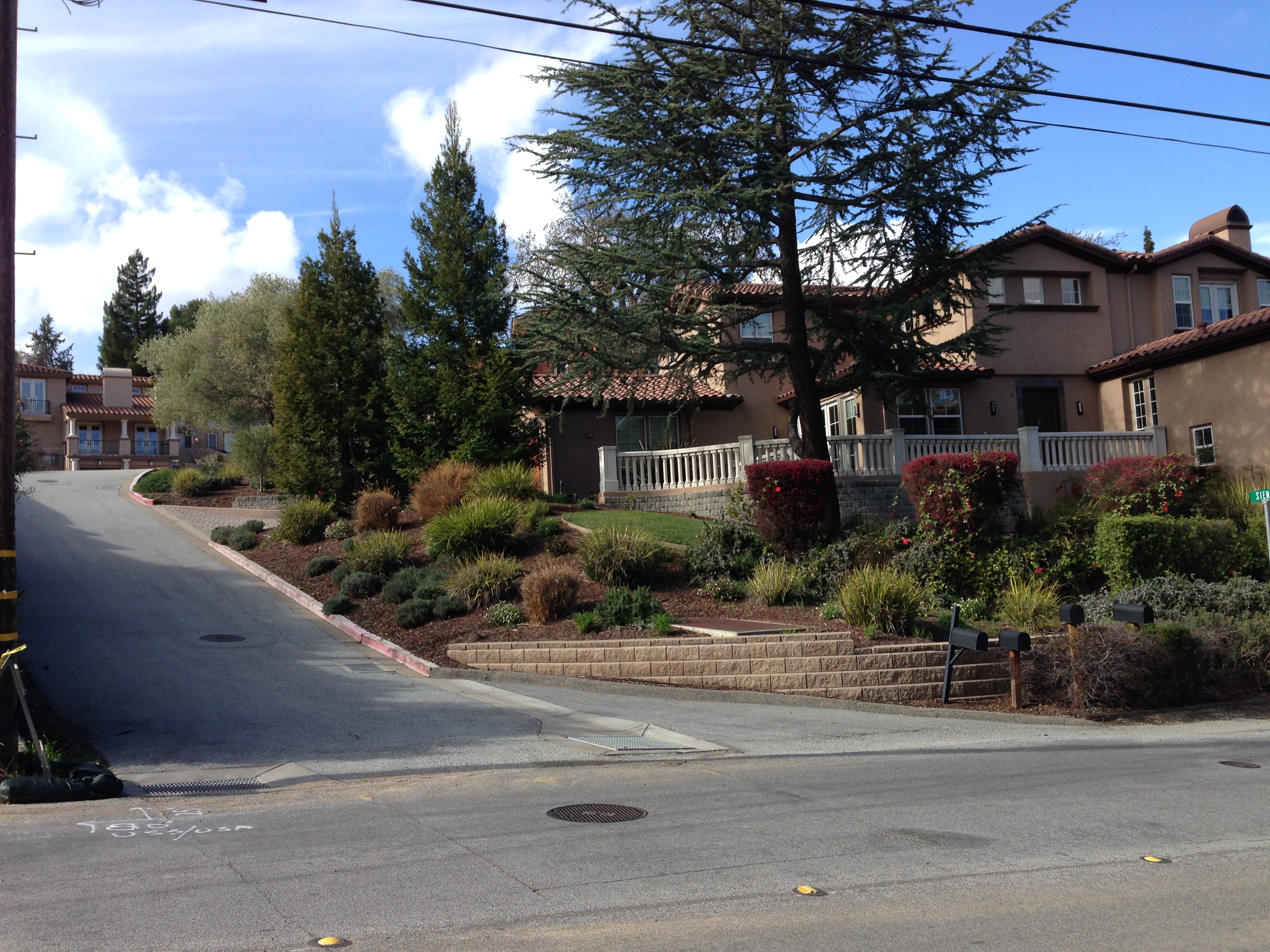
Whoever built those four houses had terrible timing: the houses were completed just as our economy took a nosedive, and they sat on the market, unsold, for a very, very long time. I presume that the developer wasn’t willing or able to sell them at a loss and so was forced to wait until the economy recovered. They eventually sold, however, and nowadays our economy is such that home prices have never been higher. So it is no surprise that the adjacent properties are being developed.
Before the land clearing began, from all appearances the next door property was a large one with a very old house (built in 1917!) in the center. A bit of inspection, however, reveals that there actually are three narrow side-by-side properties. The center one had the house on it; the ones on either side have never been developed. The builder managed to obtain all three and has torn down the house and done some clearing of the land in preparation for the construction of three houses, one on each property:
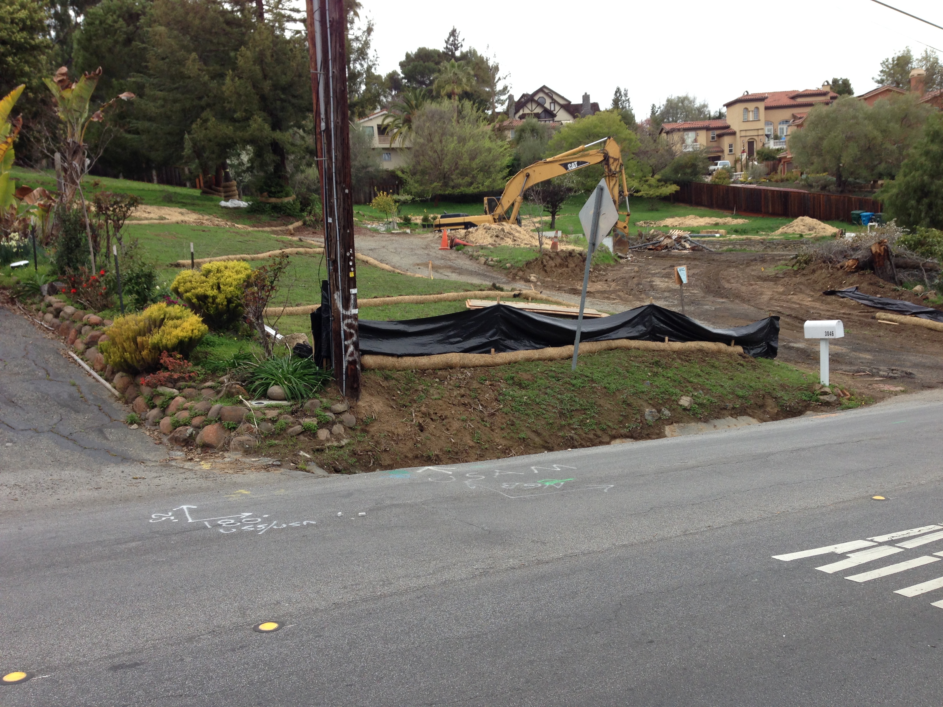
To give you some idea of how the lots are sized, in the above picture the area between the telephone pole and the mailbox is roughly one lot. The next (where the house was, and where the backhoe stands) extends from the mailbox to the right, out of the picture, about the same distance. The third is beyond that: it extends back along the fence that you can see in the right part of the picture. Each lot is about 12,000 square feet in total and is much deeper than it is wide.
This small development reminded me of another somewhat larger development potentially taking place farther up in the hills. As a resident I hadn’t been aware of this larger development; I only learned of it when I started this blog and found it listed on the Redwood City website’s “City Projects” page. Since then I’ve made several trips up to see the development area, and have followed with interest the activity of the City Council relating to it. This development, up on Laurel Way, became my next destination on that day’s walk.
Take a look at the following picture (click it to enlarge):

The grey-green house is reached by the tan driveway that you see entering the picture from the right. See that other house being built right next door? Any guesses as to how you get to it?
Here is another picture of those two houses, from a very different perspective:

In this picture, I’ve walked entirely around the two houses and am photographing them from the other side. The house on the right is the grey-green one from the previous picture. On the left is the garage for the next-door house that you could (barely) see in the previous picture. Have I confused you? Here is a side view of that same house under construction:
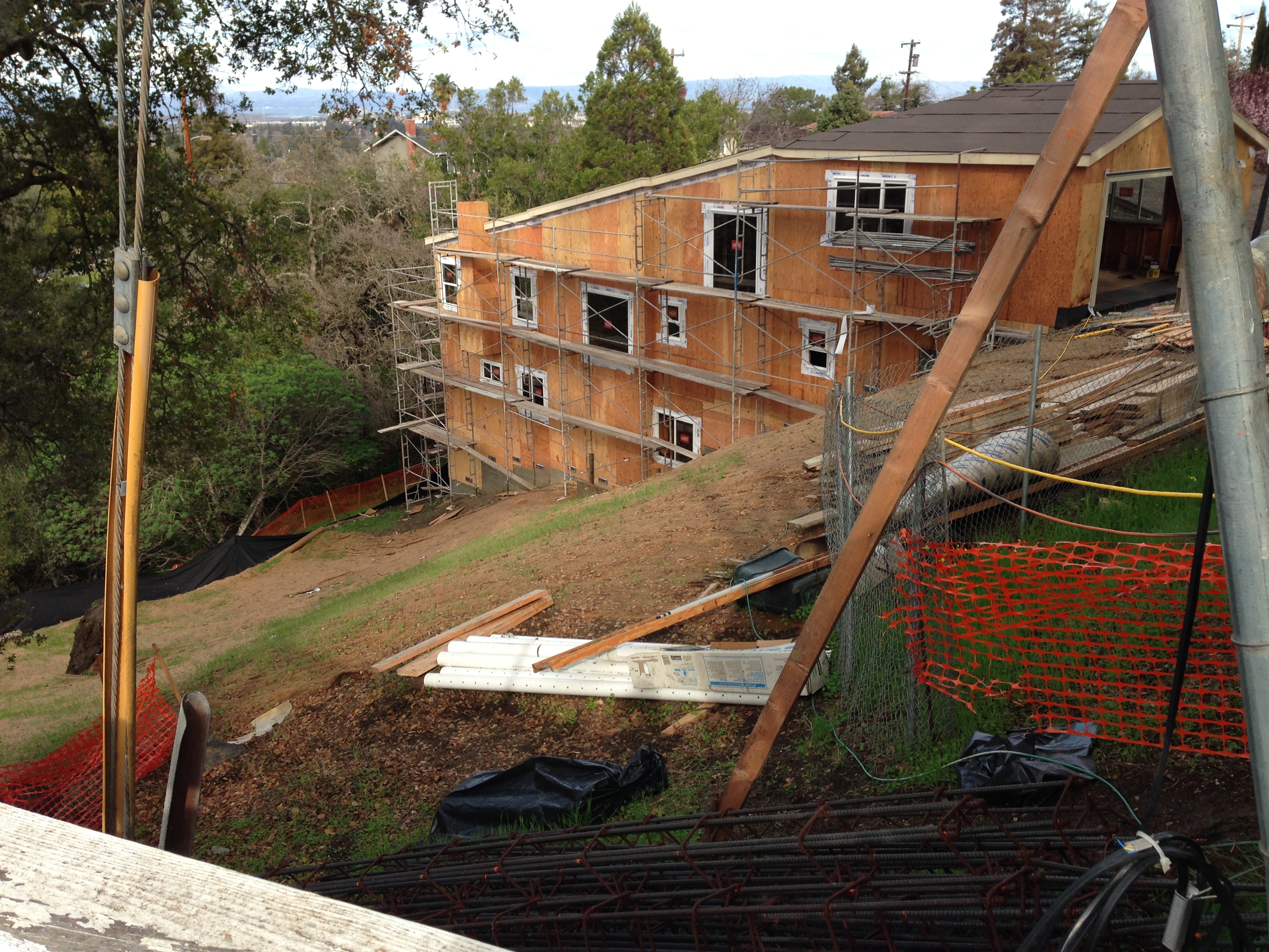
Yes, this is one of those houses that cascades down a very steep hillside. A house with the garage at the very top, and the living quarters below. Two or three stories below, it seems. This house extends all the way down such that it sits right next door to the the grey-green one. But the grey-green house is accessible from Highland Ave. (which winds through those trees behind the house in the above picture), while you enter the house under construction from much higher up, off Laurel Way.
You may not be familiar with Laurel Way; it’s just a short dead-end street that branches off Highland Ave. Where it branches there is a house that you may have seen before; one that looks something like a castle:
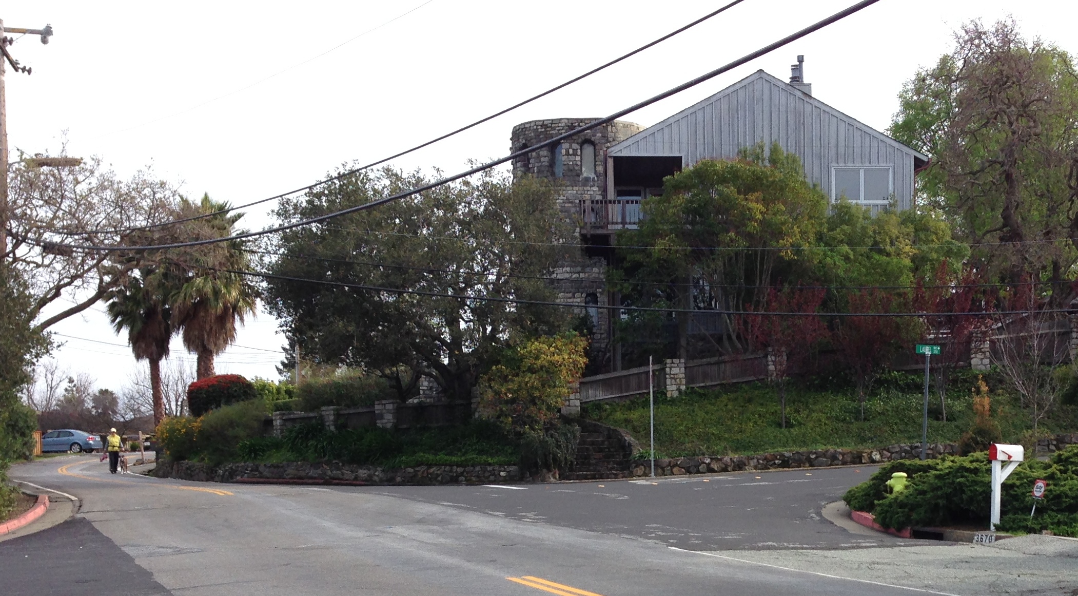
The road turning right in the above picture is Laurel Way (to the left is Altamont Way, which winds back towards Jefferson). Here’s a map showing its location (Laurel Way is the short squiggle near the bottom of the map highlighted in brownish-red):
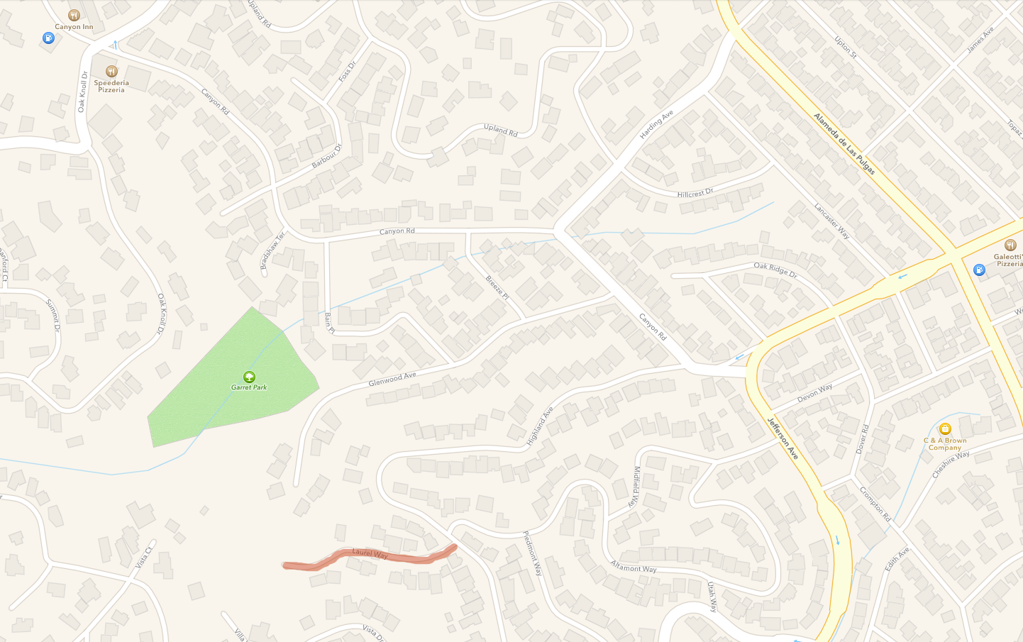
For about a block Laurel Way looks like any other street, with houses on each side. But the street quickly changes: it gets narrow and then the road turns to gravel. On the right (to the north) the hillside falls away, down to the cul-de-sac that lies at the end of Glenwood Ave. and where you’ll find Garret Park (the green triangular-shaped area in the above map). The steep hillside is thickly covered with oaks, and makes for a beautiful sight:

So why is Laurel Way something that the City Council has had to spend time on? It turns out that the area was originally subdivided back in 1926, but City Council actions since then have drastically altered how the remaining undeveloped lots can be built upon. In a 4.75-acre space the property owners are proposing the construction of 16 houses. Due to the steepness of the hillside, to the way that water flows through the area during the rainy season, and to the substandard road, the City Council rightly needed to pay close attention to any proposed projects.
The City Council, the planning commission, lawyers for the property owners (collectively known as “Laurel Way Joint Venture”), and lawyers for the opposition (“Save Laurel Way”) have spent years working through the various issues. The City Council ultimately approved the development, but put in place some severe restrictions that may make any further homebuilding impractical. The are two main ones:
- Before any permits for individual homes will even be considered, the Laurel Way Joint Venture property owners first need to upgrade the roadway, improve drainage, bring utilities to the area, and build retaining walls and install landscaping for the roadway area. This is likely to be an expensive undertaking, requiring an up-front investment on the part of all of the lot owners. When complete, a given homeowner would still have to go through the process of getting a building permit.
- Due to the extreme slope (which, in some places exceeds 30%), the city is severely limiting the square footage of each home. Of the 16 homes, only two would be allowed to exceed 3,000 square feet (and the largest, at 3,432 square feet, can be that big only because the property owner is proposing to combine three lots into a single large lot). Nine of the homes cannot exceed 2,500 square feet, and four of those are limited to less than 2,100 square feet. Too, these size figures include the garage; you need to subtract approximately 400 square feet from all of these sizes to get the actual living area.
Given the added expense of constructing any home on such a steep slope, plus the share that each property owner must contribute towards the infrastructure work, plus the amount of time all of this will take, it wouldn’t surprise me if these lots never get developed.
I grew up in the canyons of Los Angeles, and saw first-hand the devastating impact that rains and fire can have on homes built on slopes such as these. While I wouldn’t deny a property owner the right to build in an area like this (assuming that it is otherwise permissible), I for one would never live in such a place. The house under construction that I shared pictures of earlier in this post—which is on Laurel Way, although closer to the intersection and not part of the Laurel Way Joint Venture—is indicative of the kind of home you have to build on a property like this (one with lots of stairs, for instance!). The compromises that are necessary in both building and living in a home like this highlight the lengths to which people sometimes have to go in order to live in the Bay Area.
“Climate Best by Government Test”: our microclimate may well be a factor in making Redwood City such a desirable place to live. Those of us who are lucky to own homes here know just how good we have it. We may be forced to deal with water supply issues soon, but human nature tends to minimize worries about possible future issues and instead focuses on the present. And now that the rain has once again decided to make itself scarce, it is easy to ignore the dark cloud that represents the water shortage and instead just get outside and enjoy our sunny blue skies.
