
I’m writing this post ahead of time this week, because on Friday I have to drive to Los Angeles to attend a family wedding. I’m looking forward to the drive, in part because I’ll be driving right alongside the San Luis Reservoir (off Highway 152, between Highway 101 and Interstate 5), Tulare Lake (just east of Interstate 5 at Kettleman City), and Pyramid Lake (on the west side of Interstate 5, south of the Tejon Pass).
The San Luis Reservoir is a man-made lake that is used to temporarily store water from the San Joaquin-Sacramento River Delta before eventually sending it south via the California Aqueduct. Although the reservoir is part of our state’s rather complex water system and thus its level is controlled more by humans than by Mother Nature, over the last year the reservoir’s level dropped to about 345 feet above sea level (at its maximum, the water level is 200 feet higher). Compare that with today, when the reservoir is 97% full, with its water level at 539 feet above sea level. I’ve driven by the reservoir when it was close to, or at, that low point, and so I’m really interested to see it on Friday.
As for Tulare Lake, it was once the largest freshwater lake west of the Mississippi River. However, in the late 19th century the rivers that fed it were either dammed or diverted. That, along with large increases in farming that drew upon the waters of the lake, caused the lake to pretty much disappear. Apparently, though, the lake resurges somewhat from time-to-time, most recently in 1983 and 1997. And due to all of our recent rainfall, the lake is coming back with a vengeance. It is now, or likely soon will be, threatening farms and farm-worker communities. I don’t know how big the lake is at this very moment, but given how shallow the lake basin is, as our snowpack melts and water continues to find its way into the lake, it could become quite large indeed (in the past, it apparently extended for as much as 1,000 square miles). Because that the lake has been a shadow of its former self for many, many years now, though, I’ve been driving past the basin for a couple of decades now without even being aware of its existence. This trip, however, I hope to take what I presume will be a small detour to get to where I can see the lake for myself.
Southern California’s Pyramid Lake — which isn’t to be confused with the one in Nevada where the Truckee River terminates — is a holding reservoir for the California State Water Project. I have a special connection to Pyramid Lake: the dam that created it was completed in 1973, and just before that my Boy Scout troop (of which I was a member) hiked through where the lake would soon be and camped somewhere on the western side. Now, Pyramid Lake is the deepest lake in the California Water Project System, holding some 180,000 acre-feet (about 58 and a half billion gallons) of water. Like the San Luis Reservoir, Pyramid Lake is apparently full at the moment, but unlike San Luis, Pyramid Lake remained pretty much full over the last three years.
As I write this the rain has just stopped falling, and if the weather app on my iPhone can be believed, we’re done with it for the forecastable future. Whether or not that is true, the app does show another bout of high winds next Monday: it currently predicts wind speeds near my home from 10-19 mph, with gusts as high as 35 mph. If that prediction indeed comes to pass, we might be seeing a few more trees coming down, and some possible power outages.
Given how much of my home has been switched over to electricity (from gas), I find myself even more dependent than ever on a steady stream of electrons. Thus, although I have my share of complaints with PG&E, I am ever so grateful for the company’s employees and contractors who are out there on rainy, windy days and nights, repairing the downed wires.
This week I took a short walk on Monday, knowing that Tuesday and Wednesday weren’t going to be great days to be out and about, weather-wise. I headed over to Red Morton Park to check on the progress of the Veterans Memorial Building/Senior Center project, but became distracted when I saw a crew working at the intersection of Valota Road and Vera Avenue. From a distance I could tell that they were some sort of utility crew, and assumed they were working on the flashing pedestrian beacons that were recently installed at that intersection. As I got closer, however, I realized that they were instead working among the power lines. More specifically, they were working to replace a wooden telephone pole that apparently was still standing only thanks to the help of a nearby tree:

If you only look at the top of the pole, you might not think anything is wrong, but look down at the pole’s base, near where those two guy wires are anchored. It appears that the pole pretty much snapped in the middle, leaving the upper portion standing straight with the lower park leaning rather considerably. And that lower part was securely wedged into a fork in the tree:
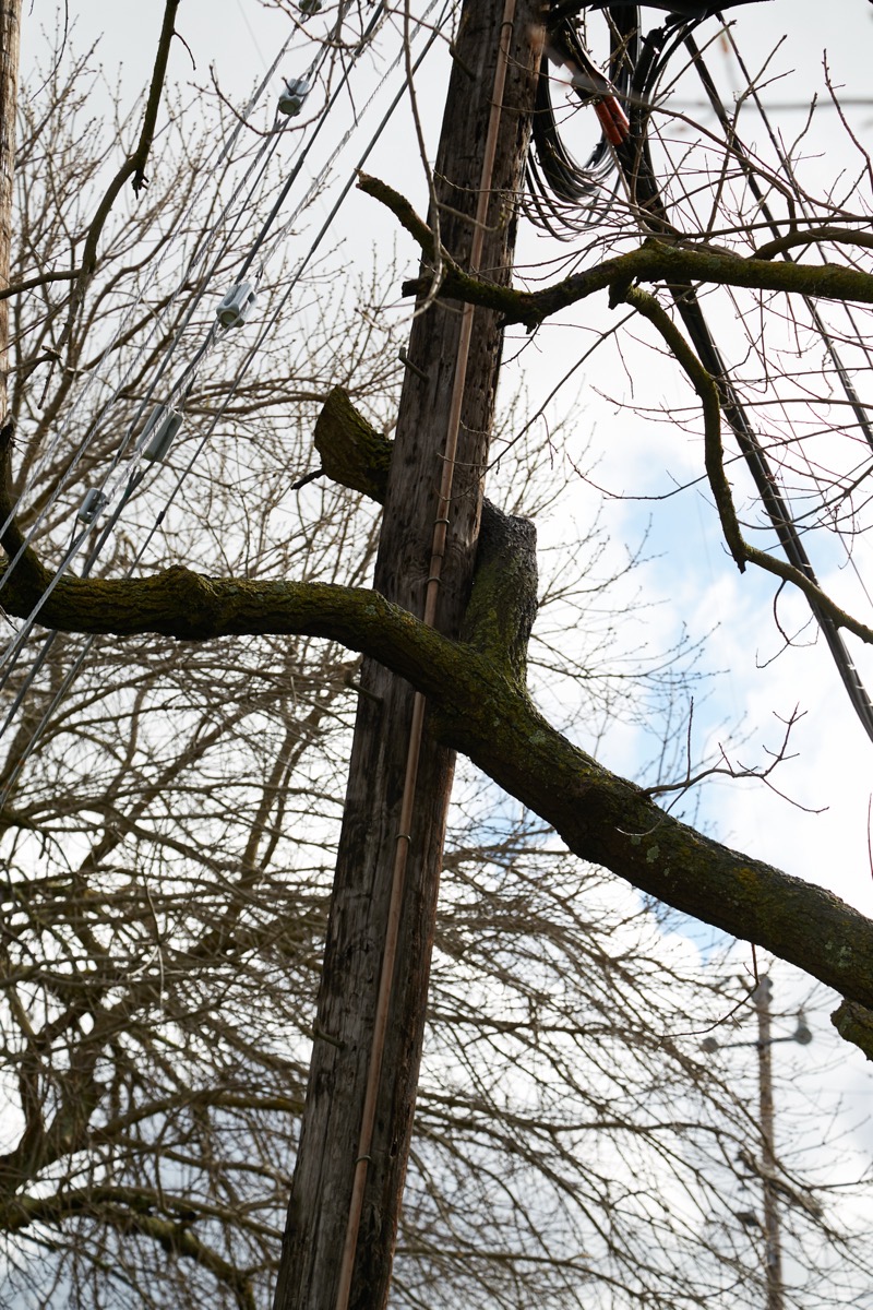
Surely the pole would have come down if it weren’t for that fortuitously placed tree.
Although we often refer to these things as “telephone poles” they of course carry more than just wires from the local phone company. This particular pole carries a number of different cables that come from across Valota Road and then, thanks to this pole, make an almost 90-degree turn and head up the street. At the top are the power lines, and lower down, just below the break, are wires that appear to carry signals for telephone, cable TV and internet.
If you’ve never thought about how they replace one of these poles without seriously disrupting service to local households, I can tell you that the process is fascinating (but somewhat slow; the work can be dangerous, so it is done carefully). I had intended for my walk to be a relatively short one, but I ended up spending three full hours just watching the crews work, and even then I only saw the preparatory stages. When I arrived they had just gotten underway, and were still unloading tools and materials — including the new pole — from their trucks. One truck, equipped with a cherry-picker, made its way to the nearest poles equipped with transformers to apparently shut off the power so that those power lines were no longer live. While that was going on, two guys unloaded the new wooden pole and, with it lying down, attached a set of metal arms to the top (the original pole had wooden arms):
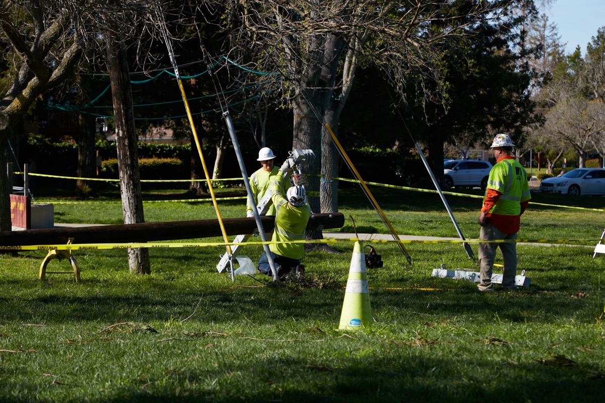
Once the cherry picker returned, a second truck, containing an extensible arm with a claw, moved into position and deployed the claw to hold the top of the power pole securely. Then, the cherry picker truck was positioned alongside, and a single worker used it to make his way to the top, cutting branches off the tree as he went in order to clear a path. He spent an hour or so carefully detaching the power lines from the pole and then reattaching them with quick-releases and ropes, so that they could be quickly and easily moved over to the new pole once it was in place.

Unfortunately, that is about when I had to leave. So I didn’t get to watch the hole being drilled in the ground for the new pole close to the old one (the arm with the claw also had a large auger that could be used to drill the hole) and I didn’t get to watch the new pole being picked up by the claw and dropped into that new hole. I also didn’t get to watch the power lines being moved from the old pole to the new one.
So what about the other wires, that carry telephone, cable TV, and such? Well, here is the interesting thing about these poles. Each company is responsible for its own wires. This particular crew was from a firm under contract to PG&E (there was at least one actual PG&E employee on site, supervising) and thus their sole responsibility was to deal with the power lines. Accordingly, after installing the new pole and moving the power lines over, they simply cut off the old pole just above where the other cables are attached, and left the old pole, still anchored in the fork of the tree:

Presumably, the other companies will, at some point, come along and move their wires over to the new pole. Then, once all of the wires have been transferred, whichever company actually owns the pole (I’m guessing that it is PG&E) will likely come back and pull the old, now shorter pole from the ground.
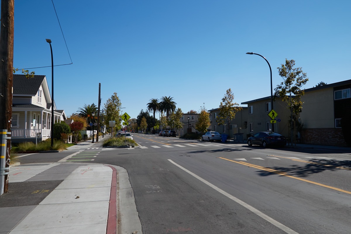
While I wish all of our wires could be placed underground — not only do overhead wires remain susceptible to falling trees and branches, let’s face it: they’re ugly — the process would be very expensive and would be logistically difficult. However, it isn’t impossible: all of the large new buildings that have been built recently have undergrounded the utilities around them. And, every once in a while we see a project such as was recently done along Middlefield Road in Redwood City (and is currently being done along Middlefield Road in North Fair Oaks) to relocate the overhead wires beneath the streets and sidewalks, turning the skies above from this:

to this:
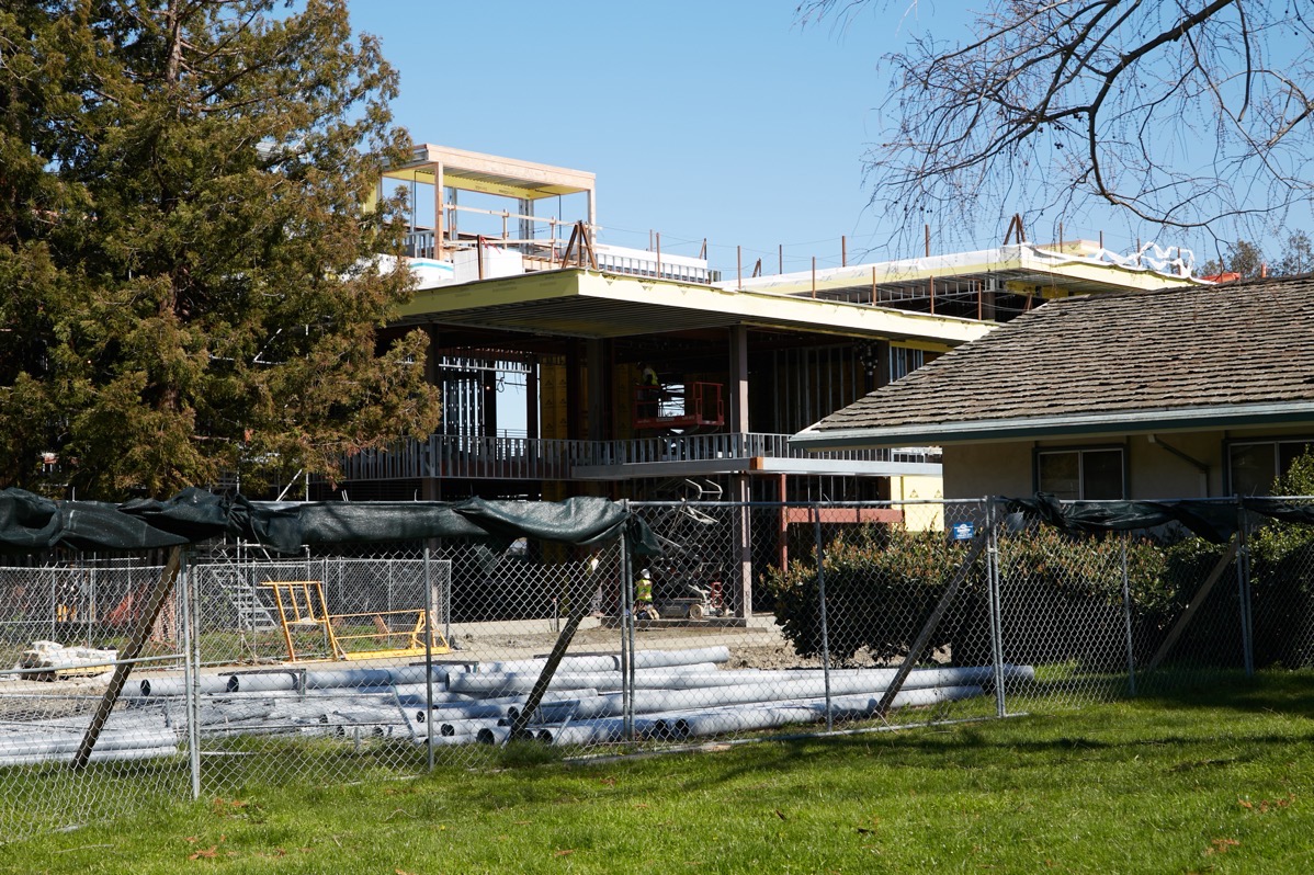
As I said, I had to leave Red Morton Park before the project was completed. But not before I took a few pictures of the Veterans Memorial Building/Senior Center. Thanks to the weather, I’m guessing, progress on the building’s exterior is slow. However, while I was there I could see that work was going on inside the building. As our weather improves, the building should rapidly begin to look like the final product. For now though, I’ll leave you with these:
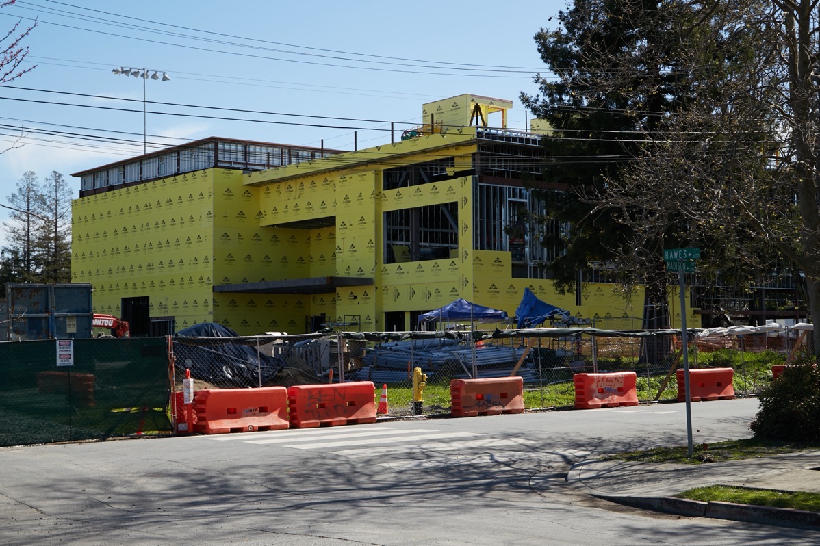
(Taken from Madison Avenue)
(Taken from Madison Avenue, with the existing Veterans Memorial Building/Senior Center in the foreground)

(Taken from within Red Morton Park, behind the existing Veterans Memorial Building/Senior Center)
Have a great (and dry!) weekend, everyone.
